
Wan Chai District is one of the 18 districts of Hong Kong. Of the four on Hong Kong Island, it is north-central, and had 166,695 residents in 2021, an increase from 152,608 residents in 2011. The district has the second-highest educationally qualified residents with the highest-bracket incomes, the second-lowest population and the third-oldest quotient. It is a relatively affluent district, with one in five persons having liquid assets of more than HKD 1 million.
Wan Chai is located in the western part of Wan Chai District on the northern shore of Hong Kong Island, Hong Kong. It is bounded by Canal Road to the east, Arsenal Street to the west, and Bowen Road to the south. The area north of Gloucester Road is often called Wan Chai North.

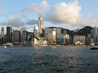
Central, also known as Central District, is the central business district of Hong Kong. It is located in the northeastern corner of the Central and Western District, on the north shore of Hong Kong Island, across Victoria Harbour from Tsim Sha Tsui, the southernmost point of Kowloon Peninsula. The area was the heart of Victoria City, although that name is rarely used today.

Sheung Wan is an area in Hong Kong, located in the north-west of Hong Kong Island, between Central and Sai Ying Pun. Administratively, it is part of the Central and Western District. The name can be variously interpreted as Upper District, or Gateway District.

Kornhill and Kornhill Gardens are apartment buildings on the northern slope of Mount Parker, in Quarry Bay, Hong Kong Island, Hong Kong. Kornhill is a private housing estate and Kornhill Gardens is a Private Sector Participation Scheme estate. The total population is approximately 30,000.

Harcourt Road is a major highway in Admiralty, Hong Kong, connecting Central and Wan Chai. It starts at Murray Road and ends at Arsenal Street. The road is 780 metres in length and has four lanes of traffic on either side. The section of Harcourt Road westbound between Rodney Street and Cotton Tree Drive features a frontage road.

Chater Road is a three-lane road in Central, Hong Kong named after Sir Paul Chater. It begins at its intersection with Pedder Street and Des Voeux Road Central in the west, and ends at Murray Road in the east. It divides Statue Square into a southern and a northern sections.

Sai Wan, also known as Western district, or simply Western, is an area in Hong Kong Island, Hong Kong that corresponds to Sai Ying Pun, Shek Tong Tsui, Belcher Bay and Kennedy Town. However, Some Hong Kong people consider Kennedy Town as the only part of Sai Wan. It formed part of the City of Victoria. West Point, a former cape where major government structures in Sai Wan are close to, also used to refer to Sai Wan.

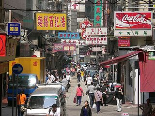
Queen's Road East is a street in Wan Chai, in the north of Hong Kong Island, Hong Kong, connecting Admiralty in the west to Happy Valley in the east. Queen's Road East is one of the four sections of Queen's Road, and historically included Queensway.

Wellington Street is a one-way street located in Central and Sheung Wan, Hong Kong. Named after Arthur Wellesley, 1st Duke of Wellington, it stretches from Wyndham Street to Queen's Road Central. The two sides of street is a mosaic of old and new buildings. Varieties of trades can be found on the street level. Street markets can be found in the adjacent lanes.

Aberdeen Street is a border street dividing Sheung Wan and Central on Hong Kong Island, Hong Kong. It ascends from Queen's Road Central to Caine Road in Mid-Levels. The street is named after George Hamilton-Gordon, 4th Earl of Aberdeen, Foreign Secretary at the time of the cession of Hong Kong Island to the United Kingdom in 1842.

Bonham Strand is a combination of two streets in Sheung Wan, Hong Kong: Bonham Strand (文咸東街) and Bonham Strand West (文咸西街).

Johnston Road is a major road in Wan Chai on the Hong Kong Island of Hong Kong.
Hillier Street, is a street in Sheung Wan of Hong Kong Island, Hong Kong, located between Connaught Road Central and Queen's Road Central.

Amoy Street is a street in the Wan Chai area of Hong Kong Island, Hong Kong. It connects Johnston Road in the north to Queen's Road East in the south. Amoy is an old name of the Chinese city of Xiamen. It has been described as "shy and retiring" by Time Out because it is a cul-de-sac with steps at one end.

Gresson Street is a street in the Wan Chai area of Hong Kong Island, Hong Kong. It connects Queen's Road East (south) to Johnston Road (north).

Stone Nullah Lane is a one-way street in Wan Chai, Hong Kong Island, Hong Kong. Named after the water channel that until 1959 ran down its middle, it stretches from Lung On Street to Queen's Road East. The street is noted for its historical landmarks, most notably the Blue House and Wan Chai Pak Tai Temple.

Swatow Street is a street in the Wan Chai area of Hong Kong island, Hong Kong. It intersects with Queen's Road East and Johnston Road. It is named after Shantou.
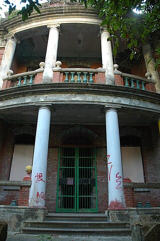
Nam Koo Terrace is a Grade I Historic Building located at No. 55 Ship Street, Wan Chai, Hong Kong, popularly known as "The Wan Chai Haunted House". The building is currently owned by Hopewell Holdings, a large property development company based in Hong Kong.
The Wan Chai Heritage Trail is a walking trail in Hong Kong. It was launched on 27 September 2009 and is two hours in duration. It was formed by the Old Wan Chai Revitalisation Initiatives Special Committee (OWCRISC) established by the Development Bureau to promote the local culture, history and architectural style of Wan Chai District.


