Stanfold, Wisconsin

Last updated

Stanfold, Wisconsin
WIMap-doton-Stanfold.png
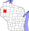
Location of Stanfold, Wisconsin
Coordinates: 45°30′19″N91°51′18″W / 45.50528°N 91.85500°W / 45.50528; -91.85500
Country Flag of the United States.svg  United States
State Flag of Wisconsin.svg  Wisconsin
County Barron
Area
  Total35.9 sq mi (93.0 km2)
  Land35.9 sq mi (92.9 km2)
  Water0.04 sq mi (0.1 km2)
Elevation
[1]
1,194 ft (364 m)
Population
 (2010)
  Total719
  Density20/sq mi (7.7/km2)
Time zone UTC-6 (Central (CST))
  Summer (DST) UTC-5 (CDT)
Area code(s) 715 & 534
FIPS code 55-76550 [2]
GNIS feature ID1584208 [1]
Website townofstanfold.com

Stanfold is a town in Barron County in the U.S. state of Wisconsin. The population was 719 at the 2010 census. [3]

Contents

Geography

Stanfold is located north of the center of Barron County. Wisconsin Highway 48 crosses the town through its center, leading east to Rice Lake and west to Cumberland. Wisconsin Highway 25 leads south from Highway 48 towards Barron, the county seat.

According to the United States Census Bureau, Stanfold has a total area of 35.9 square miles (93.0 km2), of which 35.9 square miles (92.9 km2) is land and 0.04 square miles (0.1 km2), or 0.13%, is water. [3]

Demographics

As of the census [2] of 2000, there were 669 people, 249 households, and 194 families residing in the town. The population density was 18.6 people per square mile (7.2/km2). There were 258 housing units at an average density of 7.2 per square mile (2.8/km2). The racial makeup of the town was 98.21% White, 0.15% Native American, 0.90% Asian, and 0.75% from two or more races. Hispanic or Latino of any race were 2.09% of the population.

There were 249 households, out of which 32.5% had children under the age of 18 living with them, 67.9% were married couples living together, 6.8% had a female householder with no husband present, and 21.7% were non-families. 17.3% of all households were made up of individuals, and 8.4% had someone living alone who was 65 years of age or older. The average household size was 2.67 and the average family size was 2.99.

In the town, the population was spread out, with 27.4% under the age of 18, 4.6% from 18 to 24, 30.0% from 25 to 44, 21.2% from 45 to 64, and 16.7% who were 65 years of age or older. The median age was 38 years. For every 100 females, there were 100.3 males. For every 100 females age 18 and over, there were 102.5 males.

The median income for a household in the town was $39,000, and the median income for a family was $42,292. Males had a median income of $27,917 versus $19,464 for females. The per capita income for the town was $15,683. About 4.2% of families and 5.7% of the population were below the poverty line, including 5.3% of those under age 18 and 6.7% of those age 65 or over.

Related Research Articles

<span class="mw-page-title-main">Barron County, Wisconsin</span> County in Wisconsin, United States

Barron County is a county located in the U.S. state of Wisconsin. As of the 2020 census, the population was 46,711. Its county seat is Barron. The county was created in 1859 and later organized in 1874.

<span class="mw-page-title-main">Bear Lake, Wisconsin</span> Town in Wisconsin, United States

Bear Lake is a town in Barron County in the U.S. state of Wisconsin. The population was 659 at the 2010 census.

<span class="mw-page-title-main">Cedar Lake, Wisconsin</span> Town in Wisconsin, United States

Cedar Lake is a town in Barron County in the U.S. state of Wisconsin. The population was 1,076 at the 2020 census. The unincorporated communities of Angus and Mikana are located in the town.

<span class="mw-page-title-main">Clinton, Barron County, Wisconsin</span> Town in Wisconsin, United States

Clinton is a town in Barron County, in the U.S. state of Wisconsin. The population was 879 at the 2010 census. The unincorporated community of Poskin is located in Clinton, along U.S. Route 8.

<span class="mw-page-title-main">Dovre, Wisconsin</span> Town in Wisconsin, United States

Dovre is a town in Barron County in the U.S. state of Wisconsin. The population was 849 at the 2010 census.

<span class="mw-page-title-main">Maple Grove, Barron County, Wisconsin</span> Town in Wisconsin, United States

The Town of Maple Grove is located in Barron County in the U.S. state of Wisconsin. The population was 979 at the 2010 census. The unincorporated community of Hillsdale is located in the town. The unincorporated community of Wickware is located partially in the town.

<span class="mw-page-title-main">Maple Plain, Wisconsin</span> Town in Wisconsin, United States

Maple Plain is a town in Barron County in the U.S. state of Wisconsin. The population was 803 at the 2010 census.

Sioux Creek is a town in Barron County in the U.S. state of Wisconsin. The population was 655 at the 2010 census.

Stanley is a town in Barron County in the U.S. state of Wisconsin. The population was 2,546 at the 2010 census. The town surrounds the village of Cameron but is separate from it.

<span class="mw-page-title-main">Sumner, Barron County, Wisconsin</span> Town in Wisconsin, United States

The Town of Sumner is located in Barron County in the U.S. state of Wisconsin. The population was 798 at the 2010 census. The unincorporated communities of Canton, Lehigh and Sumner are located in the town.

<span class="mw-page-title-main">Eileen, Wisconsin</span> Town in Wisconsin, United States

Eileen is a town in Bayfield County, Wisconsin, United States. The population was 681 at the 2010 census. The unincorporated community of Ashland Junction is located in the town.

<span class="mw-page-title-main">Almena, Wisconsin</span> Village in Wisconsin, United States

Almena is a village in Barron County in the U.S. state of Wisconsin. The population was 677 at the 2010 census.

<span class="mw-page-title-main">Almena (town), Wisconsin</span>

The Town of Almena is in Barron County in the U.S. state of Wisconsin. The population was 858 at the 2010 census. The Village of Almena is partially located within the town.

Barron is a town in Barron County in the U.S. state of Wisconsin. The population was 873 at the 2010 census. The town surrounds the City of Barron.

<span class="mw-page-title-main">Barron, Wisconsin</span> City in Wisconsin, United States

Barron is a city in Barron County, in the U.S. state of Wisconsin. The population was 3,733 at the 2020 census. The city is surrounded by the Town of Barron.

Cumberland is a town in Barron County in the U.S. state of Wisconsin. The population was 876 at the 2010 census. The City of Cumberland is located partially within the town.

Dallas is a town in Barron County in the U.S. state of Wisconsin. As of the 2010 census, the town had a population of 565. The Village of Dallas is within the town.

Rice Lake is a town in Barron County in the U.S. state of Wisconsin. The population was 3,041 at the 2010 census. The City of Rice Lake is located mostly within the town. The unincorporated communities of Campia and Dobie are located partially in the town.

Turtle Lake is a town in Barron County, Wisconsin, United States. The population was 624 at the 2010 census. The Village of Turtle Lake is located just north of the town. The unincorporated community of Twin Town is located partially in the town.

<span class="mw-page-title-main">Turtle Lake, Wisconsin</span> Village in Wisconsin, United States

Turtle Lake is a village in Barron and Polk counties in the U.S. state of Wisconsin. Its population was 1,064 at the 2010 census. Of these, 972 were in Barron County and 93 were in Polk County. The village is located between the towns of Almena, in Barron County, and Beaver, in Polk County.

References

  1. 1 2 "US Board on Geographic Names". United States Geological Survey. October 25, 2007. Retrieved January 31, 2008.
  2. 1 2 "U.S. Census website". United States Census Bureau . Retrieved January 31, 2008.
  3. 1 2 "Geographic Identifiers: 2010 Demographic Profile Data (G001): Stanfold town, Barron County, Wisconsin". U.S. Census Bureau, American Factfinder. Archived from the original on February 12, 2020. Retrieved May 7, 2014.