Dallas, Wisconsin

Last updated
Dallas, Wisconsin
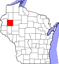
Barron County Wisconsin Incorporated and Unincorporated areas Dallas Highlighted.svg
Location of Dallas in Barron County, Wisconsin.
Coordinates: 45°15′7″N91°51′18″W / 45.25194°N 91.85500°W / 45.25194; -91.85500 Coordinates: 45°15′7″N91°51′18″W / 45.25194°N 91.85500°W / 45.25194; -91.85500
Country Flag of the United States.svg  United States
State Flag of Wisconsin.svg  Wisconsin
County Barron
Area
[1]
  Total1.48 sq mi (3.85 km2)
  Land1.45 sq mi (3.75 km2)
  Water0.04 sq mi (0.10 km2)
Elevation
[2]
1,168 ft (356 m)
Population
 (2010) [3]
  Total409
  Estimate 
(2019) [4]
345
  Density238.59/sq mi (92.11/km2)
Time zone UTC-6 (Central (CST))
  Summer (DST) UTC-5 (CDT)
Area code(s) 715 & 534
FIPS code 55-18600 [5]
GNIS feature ID1583045 [2]
Website www.dallaswi.com

Dallas is a village in Barron County in the U.S. state of Wisconsin. The population was 409 at the 2010 census. The village is located within the Town of Dallas.

Contents

Geography

Dallas is located at 45°15′34″N91°48′58″W / 45.25944°N 91.81611°W / 45.25944; -91.81611 (45.259667, −91.816243). [6]

According to the United States Census Bureau, the village has a total area of 1.49 square miles (3.86 km2), of which, 1.45 square miles (3.76 km2) of it is land and 0.04 square miles (0.10 km2) is water. [7]

Village of Dallas is along County Roads A and U.

Demographics

Historical population
CensusPop.
1910 342
1920 42524.3%
1930 4280.7%
1940 4361.9%
1950 370−15.1%
1960 4018.4%
1970 359−10.5%
1980 47732.9%
1990 452−5.2%
2000 356−21.2%
2010 40914.9%
2019 (est.)345 [4] −15.6%
U.S. Decennial Census [8]

2010 census

As of the census [3] of 2010, there were 409 people, 156 households, and 94 families living in the village. The population density was 282.1 inhabitants per square mile (108.9/km2). There were 173 housing units at an average density of 119.3 per square mile (46.1/km2). The racial makeup of the village was 97.3% White, 0.2% Native American, 1.0% Asian, 0.7% from other races, and 0.7% from two or more races. Hispanic or Latino of any race were 2.0% of the population.

There were 156 households, of which 29.5% had children under the age of 18 living with them, 45.5% were married couples living together, 10.3% had a female householder with no husband present, 4.5% had a male householder with no wife present, and 39.7% were non-families. 30.1% of all households were made up of individuals, and 14.7% had someone living alone who was 65 years of age or older. The average household size was 2.33 and the average family size was 2.85.

The median age in the village was 43.7 years. 19.8% of residents were under the age of 18; 8.6% were between the ages of 18 and 24; 22.7% were from 25 to 44; 23.7% were from 45 to 64; and 25.2% were 65 years of age or older. The gender makeup of the village was 49.9% male and 50.1% female.

2000 census

As of the census [5] of 2000, there were 356 people, 146 households, and 83 families living in the village. The population density was 244.8 people per square mile (94.8/km2). There were 169 housing units at an average density of 116.2 per square mile (45.0/km2). The racial makeup of the village was 97.75% White, 1.12% Native American, and 1.12% from two or more races. Hispanic or Latino of any race were 1.40% of the population.

There were 146 households, out of which 24.0% had children under the age of 18 living with them, 45.9% were married couples living together, 7.5% had a female householder with no husband present, and 42.5% were non-families. 34.9% of all households were made up of individuals, and 22.6% had someone living alone who was 65 years of age or older. The average household size was 2.23 and the average family size was 2.88.

In the village, the population was spread out, with 20.8% under the age of 18, 5.9% from 18 to 24, 22.8% from 25 to 44, 24.2% from 45 to 64, and 26.4% who were 65 years of age or older. The median age was 46 years. For every 100 females, there were 92.4 males. For every 100 females age 18 and over, there were 91.8 males.

The median income for a household in the village was $30,833, and the median income for a family was $37,750. Males had a median income of $32,500 versus $22,361 for females. The per capita income for the village was $14,665. About 7.9% of families and 11.6% of the population were below the poverty line, including 14.8% of those under age 18 and 22.1% of those age 65 or over.

Related Research Articles

Tununak, Alaska CDP in Alaska, United States

Tununak(Too-new-nak) is a census-designated place (CDP) in Bethel Census Area, Alaska, United States. At the 2020 census, the population was 411.

Green Valley, Solano County, California Census-designated place in California, United States

Green Valley is a census-designated place (CDP) located in Solano County, California, United States. It sits in the northeast corner of the San Francisco Bay Area and is located approximately 45 miles (72 km) from Sacramento, approximately 38 miles (61 km) from San Francisco, approximately 32 miles (51 km) from Oakland, less than 15 miles (24 km) from Napa Valley, and less than 15 miles (24 km) from both the Carquinez Bridge and the Benicia Bridge.

Gulf Gate Estates, Florida Census-designated place in Florida, United States

Gulf Gate Estates is a census-designated place (CDP) in Sarasota County, Florida, United States. The population was 10,911 at the 2010 census. It is part of the North Port–Sarasota–Bradenton Metropolitan Statistical Area.

Pontoosuc, Illinois Village in Illinois, United States

Pontoosuc is a village in Hancock County, Illinois, United States. The population was 146 at the 2010 census, down from 171 at the 2000 census.

Concord, Illinois Village in Illinois, United States

Concord is a village in Morgan County, Illinois, United States. The population was 176 at the 2000 census. It is part of the Jacksonville Micropolitan Statistical Area.

Ontonagon, Michigan Village in Michigan, United States

Ontonagon is a village in the U.S. state of Michigan. The population was 1,494 at the 2010 census. It is the county seat and only village of Ontonagon County.

Ashburn, Missouri Inactive Village in Missouri, United States

Ashburn is an inactive village in Pike County, Missouri, United States. The population was 52 at the 2010 census.

Innsbrook, Missouri Village in Missouri, United States

Innsbrook is a village in Warren County, Missouri, United States. The population was 552 at the 2010 census. The village of Innsbrook is comprised almost entirely by Innsbrook Resort—a private, gated community. The village was founded in 1998.

Eagle, Nebraska Village in Nebraska, United States

Eagle is a village in Cass County, Nebraska, United States. As of the 2010 census, the village population was 1,024.

Meyers Lake, Ohio Village in Ohio, United States

Meyers Lake is a village in Stark County in the U.S. state of Ohio. The population was 569 at the 2010 census. It is part of the Canton–Massillon Metropolitan Statistical Area.

Roswell, Ohio Village in Ohio, United States

Roswell is a village in Tuscarawas County, Ohio, United States. The population was 219 at the 2010 census.

Medina is a census-designated place (CDP) in Zapata County, Texas, United States. The population was 3,935 at the 2010 census.

Poplar, Wisconsin Village in Wisconsin, United States

Poplar is a village in Douglas County, Wisconsin, United States. The population was 603 at the 2010 census.

Ridgeland, Wisconsin Village in Wisconsin, United States

Ridgeland is a village in Dunn County, Wisconsin, United States. The population was 273 at the 2010 census.

Wheeler, Wisconsin Village in Wisconsin, United States

Wheeler is a village in Dunn County, Wisconsin, United States, along the Hay River. The population was 348 at the 2010 census.

Exeland, Wisconsin Village in Wisconsin, United States

Exeland is a village in Sawyer County, Wisconsin, United States. The population was 196 at the 2010 census.

Chaseburg, Wisconsin Village in Wisconsin, United States

Chaseburg is a village in Vernon County, Wisconsin, United States. The population was 284 at the 2010 census.

Millington, Maryland Town in Maryland, United States

Millington is a town in Kent and Queen Anne's counties in the U.S. state of Maryland. The population was 642 at the 2010 census. Millington is the head of navigation for the Chester River.

New Auburn, Wisconsin Village in Wisconsin, United States

New Auburn is a village in Barron and Chippewa counties in the U.S. state of Wisconsin. The population was 548 at the 2010 census. Of this, 528 were in Chippewa County, and 20 were in Barron County. The village is located mostly within the Town of Auburn in Chippewa County. Small portions extend east into the adjacent Town of Bloomer, Chippewa County and north into the Town of Dovre in Barron County.

Dallas is a town in Barron County in the U.S. state of Wisconsin. As of the 2010 census, the town had a population of 565. The Village of Dallas is within the town.

References

  1. "2019 U.S. Gazetteer Files". United States Census Bureau. Retrieved August 7, 2020.
  2. 1 2 "US Board on Geographic Names". United States Geological Survey. 2007-10-25. Retrieved 2008-01-31.
  3. 1 2 "U.S. Census website". United States Census Bureau . Retrieved 2012-11-18.
  4. 1 2 "Population and Housing Unit Estimates". United States Census Bureau. May 24, 2020. Retrieved May 27, 2020.
  5. 1 2 "U.S. Census website". United States Census Bureau . Retrieved 2008-01-31.
  6. "US Gazetteer files: 2010, 2000, and 1990". United States Census Bureau. 2011-02-12. Retrieved 2011-04-23.
  7. "US Gazetteer files 2010". United States Census Bureau. Archived from the original on January 24, 2012. Retrieved 2012-11-18.
  8. "Census of Population and Housing". Census.gov. Retrieved June 4, 2015.