Stanton, Iowa

Last updated

Stanton, Iowa
Downtown Stanton, Iowa.jpg
Nickname: 
The Little White City
Motto: 
Hand us the Meatballs
Montgomery County Iowa Incorporated and Unincorporated areas Stanton Highlighted.svg
Location of Stanton, Iowa
Coordinates: 40°58′52″N95°6′8″W / 40.98111°N 95.10222°W / 40.98111; -95.10222
Country Flag of the United States.svg  United States
State Flag of Iowa.svg  Iowa
County Montgomery
Area
[1]
  Total0.95 sq mi (2.46 km2)
  Land0.95 sq mi (2.46 km2)
  Water0.00 sq mi (0.00 km2)
Elevation
1,155 ft (352 m)
Population
 (2020)
  Total678
  Density715.19/sq mi (276.15/km2)
Time zone UTC-6 (Central (CST))
  Summer (DST) UTC-5 (CDT)
ZIP code
51573
Area code 712
FIPS code 19-75000
GNIS feature ID0461955
Website www.stantoniowa.com

Stanton is a city in Montgomery County, Iowa, United States. The population was 678 at the time of the 2020 census. [2]

Contents

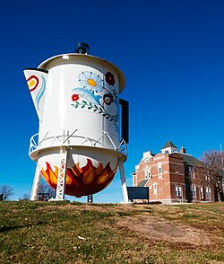
Stanton was first settled by Swedish immigrants. Stanton is best known for its two water towers, the tanks of which are painted and shaped like a giant coffee pot and coffee cup (billed as "the largest Swedish coffee pot in the world"). These also allude to the fact that Stanton is the hometown of actress Virginia Christine, best known to television viewers as "Mrs. Olsen" in classic commercials for Folgers.

The largest Swedish coffee pot in the world Stanton Coffee Pot.jpg
The largest Swedish coffee pot in the world

History

Stanton was laid out in 1870. [3]

Geography

According to the United States Census Bureau, the city has a total area of 0.92 square miles (2.38 km2), all land. [4]

Demographics

Historical populations
YearPop.±%
1880 247    
1890 399+61.5%
1900 404+1.3%
1910 653+61.6%
1920 749+14.7%
1930 607−19.0%
1940 571−5.9%
1950 570−0.2%
1960 514−9.8%
1970 574+11.7%
1980 747+30.1%
1990 692−7.4%
2000 714+3.2%
2010 689−3.5%
2020 678−1.6%
Source: "U.S. Census website". United States Census Bureau . Retrieved March 29, 2020. and Iowa Data Center
Source:
U.S. Decennial Census [5] [2]

2010 census

At the 2010 census there were 689 people in 268 households, including 190 families, in the city. The population density was 748.9 inhabitants per square mile (289.2/km2). There were 299 housing units at an average density of 325.0 per square mile (125.5/km2). The racial makup of the city was 99.9% White and 0.1% from two or more races. Hispanic or Latino of any race were 0.1%. [6]

Of the 268 households 28.4% had children under the age of 18 living with them, 62.3% were married couples living together, 5.2% had a female householder with no husband present, 3.4% had a male householder with no wife present, and 29.1% were non-families. 25.7% of households were one person and 13.1% were one person aged 65 or older. The average household size was 2.39 and the average family size was 2.84.

The median age was 48.7 years. 21.6% of residents were under the age of 18; 4% were between the ages of 18 and 24; 18.9% were from 25 to 44; 30.1% were from 45 to 64; and 25.3% were 65 or older. The gender makeup of the city was 44.0% male and 56.0% female.

2000 census

At the 2000 census there were 714 people in 271 households, including 188 families, in the city. The population density was 803.9 inhabitants per square mile (310.4/km2). There were 285 housing units at an average density of 320.9 per square mile (123.9/km2). The racial makup of the city was 98.7% White, 0.6% Native American, 0.1% Asian, 0.3% from other races, and 0.3% from two or more races. Hispanic or Latino of any race were 0.6%. [7]

Of the 271 households 35.4% had children under the age of 18 living with them, 62.0% were married couples living together, 4.8% had a female householder with no husband present, and 30.3% were non-families. 28.0% of households were one person and 15.1% were one person aged 65 or older. The average household size was 2.46 and the average family size was 3.01.

26.3% are under the age of 18, 4.5% from 18 to 24, 26.6% from 25 to 44, 19.3% from 45 to 64, and 23.2% 65 or older. The median age was 41 years. For every 100 females, there were 85.5 males. For every 100 females age 18 and over, there were 78.3 males.

The median household income was $36,607 and the median family income was $46,136. Males had a median income of $30,625 versus $20,852 for females. The per capita income for the city was $15,628. About 3.7% of families and 6.1% of the population were below the poverty line, including 4.4% of those under age 18 and 4.2% of those age 65 or over.

Education

Stanton Community School District operates public schools.

Notable People

The Little White City

Stanton is commonly known as the Little White City. Although commonly believed to be in reference to almost everyone painting their house white, the nickname originated from railroad conductors. The town had a small white painted train depot, in contrast to most being plain, brown, treated wood.

Related Research Articles

<span class="mw-page-title-main">Nodaway, Iowa</span> City in Iowa, United States

Nodaway is a city in Nodaway Township, Adams County, Iowa, United States. The population was 74 at the time of the 2020 census. Nodaway was incorporated in 1900.

<span class="mw-page-title-main">Shellsburg, Iowa</span> City in Iowa, United States

Shellsburg is a city in Benton County, Iowa, United States. The population was 961 at the time of the 2020 census. It is part of the Cedar Rapids Metropolitan Statistical Area.

<span class="mw-page-title-main">Rinard, Iowa</span> City in Iowa, United States

Rinard is a city in Calhoun County, Iowa, United States. The population was 38 at the time of the 2020 census.

<span class="mw-page-title-main">Davis City, Iowa</span> City in Iowa, United States

Davis City is a city in Decatur County, Iowa, United States. The population was 179 at the time of the 2020 census.

<span class="mw-page-title-main">Grand River, Iowa</span> City in Iowa, United States

Grand River is a city in northwest Decatur County, Iowa, United States. The population was 196 at the time of the 2020 census.

<span class="mw-page-title-main">Van Wert, Iowa</span> City in Iowa, United States

Van Wert is a city in northern Decatur County, Iowa, United States. The population was 178 at the time of the 2020 census.

<span class="mw-page-title-main">Paton, Iowa</span> City in Iowa, United States

Paton is a city in Greene County, Iowa, United States. The population was 221 at the time of the 2020 census.

<span class="mw-page-title-main">Wyoming, Iowa</span> City in Iowa, United States

Wyoming is a city in Jones County, Iowa, United States. The population was 523 at the time of the 2020 census. It is part of the Cedar Rapids Metropolitan Statistical Area.

<span class="mw-page-title-main">Thornburg, Iowa</span> City in Iowa, United States

Thornburg is a village in Keokuk County, Iowa, United States. The population was 45 at the time of the 2020 census. Its sole enterprise is the Tri-County Community School, a public school serving grades K-12.

<span class="mw-page-title-main">Columbus City, Iowa</span> City in Iowa, United States

Columbus City is a city in western Louisa County, Iowa, United States. The population was 392 at the 2020 census. It is part of the Muscatine Micropolitan Statistical Area.

<span class="mw-page-title-main">Cotter, Iowa</span> City in Iowa, United States

Cotter is a city in western Louisa County, Iowa, United States. The population was 39 at the 2020 census. It is part of the Muscatine Micropolitan Statistical Area.

<span class="mw-page-title-main">Oakville, Iowa</span> City in Iowa, United States

Oakville is a city in southeastern Louisa County, Iowa, United States. The population was 200 at the time of the 2020 census. It is part of the Muscatine Micropolitan Statistical Area.

<span class="mw-page-title-main">Patterson, Iowa</span> City in Iowa, United States

Patterson is a city in Madison County, Iowa, United States. The population was 176 at the time of the 2020 census. It is part of the Des Moines–West Des Moines Metropolitan Statistical Area.

<span class="mw-page-title-main">Gilman, Iowa</span> City in Iowa, United States

Gilman is a city in the southeastern corner of Marshall County, Iowa, United States. The population was 542 at the time of the 2020 census.

<span class="mw-page-title-main">Maloy, Iowa</span> City in Iowa, United States

Maloy is a city in southwest Ringgold County, Iowa, United States, along the Platte River. The population was 22 at the time of the 2020 census.

<span class="mw-page-title-main">Westphalia, Iowa</span> City in Iowa, United States

Westphalia is a city in Shelby County, Iowa, United States. The population was 126 at the time of the 2020 census.

<span class="mw-page-title-main">Spring Hill, Iowa</span> City in Iowa, United States

Spring Hill is a city in Warren County, Iowa, United States. The population was 68 at the time of the 2020 census. It is part of the Des Moines–West Des Moines Metropolitan Statistical Area.

<span class="mw-page-title-main">St. Marys, Iowa</span> City in Iowa, United States

St. Marys or Saint Marys is a city in Warren County, Iowa, United States. The population was 108 at the time of the 2020 census.

<span class="mw-page-title-main">Crawfordsville, Iowa</span> City in Iowa, United States

Crawfordsville is a city in Washington County, Iowa, United States. It is part of the Iowa City, Iowa Metropolitan Statistical Area. The population was 277 at the 2020 census.

<span class="mw-page-title-main">West Chester, Iowa</span> City in Iowa, United States

West Chester is a city in Washington County, Iowa, United States. It is part of the Iowa City, Iowa Metropolitan Statistical Area. The population was 144 at the time of the 2020 census.

References

  1. "2020 U.S. Gazetteer Files". United States Census Bureau. Retrieved March 16, 2022.
  2. 1 2 "2020 Census State Redistricting Data". census.gov. United states Census Bureau. Retrieved August 12, 2021.
  3. History of Montgomery County, Iowa: Containing a History of the County, Its Cities, Towns, Etc. Iowa Historical & Biographical Company. 1881. p. 528.
  4. "US Gazetteer files 2010". United States Census Bureau. Archived from the original on January 25, 2012. Retrieved May 11, 2012.
  5. "Census of Population and Housing". Census.gov. Retrieved June 4, 2015.
  6. "U.S. Census website". United States Census Bureau . Retrieved May 11, 2012.
  7. "U.S. Census website". United States Census Bureau . Retrieved January 31, 2008.