Stedman, North Carolina

Last updated

Stedman, North Carolina
Stedman, North Carolina.JPG
Stedman Soda Shop and Stedman Drug
Cumberland County North Carolina incorporated and unincorporated areas Stedman highlighted.svg
Location in Cumberland County and the state of North Carolina.
Coordinates: 35°00′42″N78°41′59″W / 35.01167°N 78.69972°W / 35.01167; -78.69972
Country United States
State North Carolina
County Cumberland
Settled1841
Incorporated1917
Government
  MayorMartin L. Jones
Area
[1]
  Total1.69 sq mi (4.37 km2)
  Land1.69 sq mi (4.37 km2)
  Water0.00 sq mi (0.00 km2)
Elevation
[2]
128 ft (39 m)
Population
 (2020)
  Total1,277
  Density756.52/sq mi (292.13/km2)
Time zone UTC-5 (Eastern (EST))
  Summer (DST) UTC-4 (EDT)
ZIP code
28391
Area codes 910, 472
FIPS code 37-64840 [3]
GNIS feature ID2406663 [2]

Stedman is a town in Cumberland County, North Carolina, United States. The population was 1,028 at the 2010 census. [4] It is named for Civil War Major Charles Manly Stedman. [5]

Contents

History

Stedman was settled in 1841 when John Culbreth Blocker built a stagecoach house and post office on land that he had purchased. The town was incorporated in 1917. [6]

The Maxwell House was listed on the National Register of Historic Places in 1985. [7]

Geography

Stedman is located in eastern Cumberland County. North Carolina Highway 24 passes through the town, leading west 11 miles (18 km) to Fayetteville, the county seat, and east 22 miles (35 km) to Clinton.

According to the United States Census Bureau, the town has a total area of 2.1 square miles (5.4 km2), all land. [4]

Demographics

Historical population
CensusPop.Note
1920 121
1930 289138.8%
1940 35623.2%
1950 42419.1%
1960 4588.0%
1970 50510.3%
1980 72343.2%
1990 577−20.2%
2000 66415.1%
2010 1,02854.8%
2020 1,27724.2%
U.S. Decennial Census [8]

2020 census

Stedman racial composition [9]
RaceNumberPercentage
White (non-Hispanic)93973.53%
Black or African American (non-Hispanic)12910.1%
Native American 151.17%
Asian 80.63%
Other/Mixed 1058.22%
Hispanic or Latino 816.34%

As of the 2020 United States census, there were 1,277 people, 501 households, and 329 families residing in the town.

2000 census

As of the census [3] of 2000, there were 664 people, 261 households, and 196 families residing in the town. The population density was 484.0 inhabitants per square mile (186.9/km2). There were 286 housing units at an average density of 208.5 per square mile (80.5/km2). The racial makeup of the town was 82.53% White, 12.50% African American, 1.05% Native American, 0.45% Asian, 0.15% Pacific Islander, 1.20% from other races, and 2.11% from two or more races. Hispanic or Latino of any race were 2.41% of the population.

There were 261 households, out of which 32.2% had children under the age of 18 living with them, 57.1% were married couples living together, 12.6% had a female householder with no husband present, and 24.9% were non-families. 20.7% of all households were made up of individuals, and 7.7% had someone living alone who was 65 years of age or older. The average household size was 2.54 and the average family size was 2.93.

In the town, the population was spread out, with 23.8% under the age of 18, 7.1% from 18 to 24, 28.8% from 25 to 44, 28.2% from 45 to 64, and 12.2% who were 65 years of age or older. The median age was 40 years. For every 100 females, there were 96.4 males. For every 100 females age 18 and over, there were 89.5 males.

The median income for a household in the town was $47,321, and the median income for a family was $55,294. Males had a median income of $36,250 versus $21,875 for females. The per capita income for the town was $19,233. About 4.3% of families and 10.0% of the population were below the poverty line, including 18.8% of those under age 18 and 12.3% of those age 65 or over.

Related Research Articles

<span class="mw-page-title-main">Cumberland County, North Carolina</span> County in North Carolina, United States

Cumberland County is a county located in the U.S. state of North Carolina. As of the 2020 census, the population was 334,728, making it the fifth-most populous county in North Carolina. Its county seat is Fayetteville. Cumberland County is part of the Fayetteville, NC Metropolitan Statistical Area.

<span class="mw-page-title-main">Cumberland, Indiana</span> Town in Indiana, United States

Cumberland is a town in Hancock and Marion counties, Indiana, United States. The population was 5,954 at the 2020 census, up from 5,169 in 2010.

<span class="mw-page-title-main">East Arcadia, North Carolina</span> Town in North Carolina, United States

East Arcadia is a town in Bladen County, North Carolina, United States. The population was 487 at the 2010 census. This town is known for high crime rate. Most of the crimes that happen here are Vandalism, the selling of narcotics, Robbery, And unarmed and armed Assault

<span class="mw-page-title-main">Eastover, North Carolina</span> Town in North Carolina, United States

Eastover is a town in Cumberland County, North Carolina, United States. The population was 3,628 at the 2010 census. It was incorporated on July 25, 2007.

<span class="mw-page-title-main">Godwin, North Carolina</span> Town in North Carolina, United States

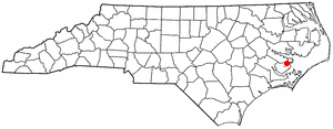
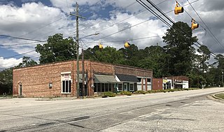
Godwin is a town in Cumberland County, North Carolina, United States. The population was 139 at the 2010 census.

<span class="mw-page-title-main">Hope Mills, North Carolina</span> Town in North Carolina, United States

Hope Mills is a town in Cumberland County, North Carolina, United States. Its population was 15,176 at the 2010 census.

<span class="mw-page-title-main">Linden, North Carolina</span> Town in North Carolina, United States

Linden is a town in Cumberland County, North Carolina, United States. The population was 130 at the 2010 census, the mayor is Frances Collier.

<span class="mw-page-title-main">Spring Lake, North Carolina</span> Town in North Carolina, United States

Spring Lake is a town in Cumberland County, North Carolina, United States. The 2010 census recorded the population at 11,964 people, with an estimated population in 2019 of 12,005.

<span class="mw-page-title-main">Vander, North Carolina</span> Census-designated place in North Carolina, United States

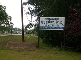
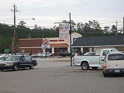
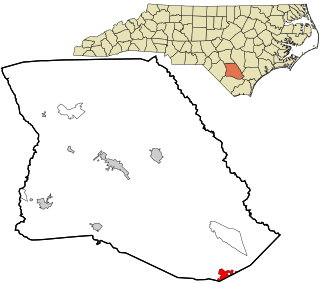
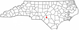
Vander is an unincorporated community and census-designated place (CDP) in Cumberland County, North Carolina, United States. The population was 1,388 at the 2020 census.

<span class="mw-page-title-main">Wade, North Carolina</span> Town in North Carolina, United States

Wade is a town in Cumberland County, North Carolina, United States. The population was 556 at the 2010 census.

<span class="mw-page-title-main">Gatesville, North Carolina</span> Town in North Carolina, United States

Gatesville is a town in Gates County, North Carolina, United States. The population was 321 at the 2010 census. It is the county seat of Gates County.

<span class="mw-page-title-main">Dunn, North Carolina</span> City in North Carolina, United States

Dunn is the most populous city of Harnett County, North Carolina, United States. The population was 9,263 at the 2010 census, and an estimated 9,718 in 2018. It is the anchor city of the Dunn Micropolitan Area, population 114,678, which consists of Harnett County and is a part of the greater Raleigh–Durham–Cary Combined Statistical Area (CSA) as defined by the United States Census Bureau.

<span class="mw-page-title-main">Rockfish, North Carolina</span> Census-designated place in North Carolina, United States

Rockfish is a census-designated place (CDP) in Hoke County, North Carolina, United States. The population was 3,298 at the 2010 census, up from 2,353 at the 2000 census.

<span class="mw-page-title-main">Benson, North Carolina</span> Town in North Carolina, United States

Benson is a town in Johnston County, North Carolina, United States, near the intersection of Interstates 95 and 40. Benson celebrates Mule Days on the fourth Saturday of September, a festival that attracts over 60,000 people each year. In 2010, the population was 3,311, up from 2,923 in 2000.

<span class="mw-page-title-main">Autryville, North Carolina</span> Town in North Carolina, United States

Autryville is a town in Sampson County, North Carolina, United States. The population was 167 at the 2020 census. Located along the west side of Sampson County along the banks of South River at the Cumberland County line, Autryville is governed by a mayor and a five-member town commission. The town is about 15 miles east-southeast of Fayetteville along NC 24.

<span class="mw-page-title-main">Roseboro, North Carolina</span> Town in North Carolina, United States

Roseboro is a town in Sampson County, North Carolina, United States. The population was 1,191 at the 2010 census.

<span class="mw-page-title-main">Fayetteville, Texas</span> City in Texas, United States

Fayetteville is a city in Fayette County, Texas. The population was 246 at the 2020 census.

<span class="mw-page-title-main">Fayetteville, West Virginia</span> Town in West Virginia, United States

Fayetteville is a town in and the county seat of Fayette County, West Virginia, United States. The population was 2,887 at the 2020 census.

<span class="mw-page-title-main">Carpendale, West Virginia</span> Town in West Virginia, United States

Carpendale is a town in Mineral County, West Virginia, United States, and part of the Cumberland, MD-WV Metropolitan Statistical Area'. The population was 861 at the 2020 census. Carpendale was incorporated on January 2, 1990, by the Circuit Court. The town is a combination of three subdivisions of which its name reflects: Carpenters Addition, Millerdale I, and Millerdale II. There are no stores in Carpendale and there is only one road in and out of the town.

<span class="mw-page-title-main">Falcon, North Carolina</span> Town in North Carolina, United States

Falcon is a town in Cumberland and Sampson counties in the U.S. state of North Carolina. The population was 258 at the 2010 census.

References

  1. "ArcGIS REST Services Directory". United States Census Bureau. Retrieved September 20, 2022.
  2. 1 2 U.S. Geological Survey Geographic Names Information System: Stedman, North Carolina
  3. 1 2 "U.S. Census website". United States Census Bureau . Retrieved January 31, 2008.
  4. 1 2 "Geographic Identifiers: 2010 Demographic Profile Data (G001): Stedman town, North Carolina". U.S. Census Bureau, American Factfinder. Archived from the original on February 12, 2020. Retrieved January 6, 2015.
  5. Rodger Mullen. "Business replaces farms". The Fayetteville Observer. Retrieved November 1, 2008.[ dead link ]
  6. "Living Here" (Newspaper magazine insert). The Fayetteville Observer. August 15, 2009. p. 16.{{cite news}}: |format= requires |url= (help)
  7. "National Register Information System". National Register of Historic Places . National Park Service. July 9, 2010.
  8. "Census of Population and Housing". Census.gov. Retrieved June 4, 2015.
  9. "Explore Census Data". data.census.gov. Retrieved December 23, 2021.