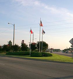
Spring Lake, North Carolina | |
---|---|
Motto: "Unity for Prosperity" [1] | |
Coordinates: 35°11′04″N78°59′46″W / 35.18444°N 78.99611°W | |
Country | United States |
State | North Carolina |
County | Cumberland |
Government | |
• Type | Council-Manager |
• Current mayor | Kia Anthony [2] |
• First mayor | Grady Howard |
Area | |
• Total | 23.84 sq mi (61.74 km2) |
• Land | 23.62 sq mi (61.18 km2) |
• Water | 0.22 sq mi (0.56 km2) |
Elevation | 171 ft (52 m) |
Population (2020) | |
• Total | 11,660 |
• Density | 493.65/sq mi (190.60/km2) |
Time zone | UTC-5 (Eastern (EST)) |
• Summer (DST) | UTC-4 (EDT) |
ZIP code | 28390 |
Area codes | 910, 472 |
FIPS code | 37-64180 [5] |
GNIS feature ID | 2407386 [4] |
Website | www |
Spring Lake is a town in Cumberland County, North Carolina, United States. The 2010 census recorded the population at 11,964 people, [6] with an estimated population in 2019 of 12,005. [7]
The current name of the town first appeared around 1923 for a spring fed lake, which probably formed when the railroad was built about 1860. The community grew slowly until World War II. At its incorporation, the town selected the post office on Main Street as the center of town. The town limits extended only eight-tenths of a mile from its center, but increased rapidly as nearby Fort Bragg was built up. Today, Spring Lake remains a quaint town with its close ties to nearby Fort Liberty. [8]
Previously, the area was called "Clayton Cut", due to the pathway cut that ran through the area where the railroad later resided, and also "Prince's Siding", after a man named Prince who owned a sawmill on this land.
Spring Lake was officially incorporated on April 9, 1951. Grady Howard was named interim mayor on this date, and was officially elected the first mayor of Spring Lake on June 5, 1951.
The modern growth spurt beginning in World War II is attributed to the proximity of Fort Liberty.
Long Valley Farm was listed on the National Register of Historic Places in 1994. [9]
Spring Lake is located in northwestern Cumberland County. It is bordered to the south by the city of Fayetteville, the Cumberland County seat, to the west by Hoke and Moore counties, and to the north by Harnett County. Large portions of the town limits are occupied by Pope Air Force Base and parts of Fort Liberty.
North Carolina Highways 87 and 24 run concurrently through the town, leading south 11 miles (18 km) to downtown Fayetteville. NC 87 leads north 26 miles (42 km) to Sanford, while NC 24 runs northwest 31 miles (50 km) to Carthage. North Carolina Highway 210 leads northeast 18 miles (29 km) to Lillington and southeast as Murchison Road 10 miles (16 km) to downtown Fayetteville.
According to the United States Census Bureau, the town of Spring Lake has a total area of 23.2 square miles (60.2 km2), of which 23.1 square miles (59.7 km2) is land and 0.19 square miles (0.5 km2), or 0.88%, is water. [6] The Little River, a tributary of the Cape Fear River, runs the length of the town from west to east, passing north of the town center.
It includes sections of the Fort Liberty (formerly Fort Bragg) property, including Pope Field. [10]
Census | Pop. | Note | %± |
---|---|---|---|
1960 | 4,110 | — | |
1970 | 3,968 | −3.5% | |
1980 | 6,273 | 58.1% | |
1990 | 7,524 | 19.9% | |
2000 | 8,098 | 7.6% | |
2010 | 11,964 | 47.7% | |
2020 | 11,660 | −2.5% | |
U.S. Decennial Census [11] |
Race / Ethnicity (NH = Non-Hispanic) | Pop 2000 [12] | Pop 2010 [13] | Pop 2020 [14] | % 2000 | % 2010 | % 2020 |
---|---|---|---|---|---|---|
White alone (NH) | 2,391 | 4,889 | 3,709 | 29.53% | 40.86% | 31.81% |
Black or African American alone (NH) | 4,053 | 4,131 | 4,415 | 50.05% | 34.53% | 37.86% |
Native American or Alaska Native alone (NH) | 60 | 111 | 78 | 0.74% | 0.93% | 0.67% |
Asian alone (NH) | 286 | 335 | 384 | 3.53% | 2.80% | 3.29% |
Pacific Islander alone (NH) | 29 | 47 | 103 | 0.36% | 0.39% | 0.88% |
Other Race alone (NH) | 22 | 34 | 98 | 0.27% | 0.28% | 0.84% |
Mixed race or Multiracial (NH) | 294 | 578 | 800 | 3.63% | 4.83% | 6.86% |
Hispanic or Latino (any race) | 963 | 1,839 | 2,073 | 11.89% | 15.37% | 17.78% |
Total | 8,098 | 11,964 | 11,660 | 100.00% | 100.00% | 100.00% |
As of the 2020 United States census, there were 11,660 people, 4,369 households, and 2,653 families residing in the town.
As of the census [5] of 2010, there were 11,964 people, 4,202 households, and 2,880 families residing in the town. The population density was 517.9 inhabitants per square mile (200.0/km2). There were 4,855 housing units at an average density of 210.2 units per square mile (81.3/km2). The racial makeup of the town was 47.2% White, 36.3% African American, 1.1% Native American, 3.0% Asian, 0.5% Pacific Islander, 5.1% some other race, and 6.9% from two or more races. Hispanic or Latino of any race were 15.4% of the population. [15]
There were 4,202 households, out of which 46.2% had children under the age of 18 living with them, 44.7% were headed by married couples living together, 18.8% had a female householder with no husband present, and 31.5% were non-families. 25.5% of all households were made up of individuals, and 4.0% were someone living alone who was 65 years of age or older. The average household size was 2.65, and the average family size was 3.21. [15]
In the town, the population was spread out, with 31.2% under the age of 18, 19.3% from 18 to 24, 31.8% from 25 to 44, 13.0% from 45 to 64, and 4.8% who were 65 years of age or older. The median age was 24.9 years. For every 100 females, there were 104.0 males. For every 100 females age 18 and over, there were 106.2 males. [15]
For the period 2009–13, the estimated median annual income for a household in the town was $36,538, and the median income for a family was $38,243. Male full-time workers had a median income of $34,921 versus $29,473 for females. The per capita income for the town was $15,852. About 19.5% of families and 23.2% of the population were below the poverty line, including 28.7% of those under age 18 and 21.1% of those age 65 or over. [16]
In May 2009, Spring Lake's police department was stripped of its authority, with the Cumberland County Sheriff's Office assuming command in the town. This happened after two of its senior officers were arrested on an array of charges including embezzlement, larceny, obstruction of justice, second-degree kidnapping, and breaking and entering. [17] The District Attorney dropped the majority of misdemeanor cases the department had investigated, saying "We can no longer rely upon the basic presumed integrity of the work product of this department." [17] Chief of Police A.C. Brown resigned in the aftermath of the scandal. The town has since revamped the department with the hiring of new officers and a new police chief, Dysoaneik Spellman. The power to investigate misdemeanors was restored in 2010.
Spring Lake is served by a mayor and town board. Members are elected for two year renewable terms. The current board consists of mayor Kia Anthony and aldermen Marvin Lackman, Raul Palacios as well as alderwomen Adrian Jones Thompson, Sona Cooper and mayor pro-tem Robyn Chadwick.
The next municipal election in Spring Lake will be in November 2023. [18]
The Cumberland County Schools district serves most areas for grades PK-12. [19] The Department of Defense Education Activity (DoDEA) operates public schools on Fort Liberty for PK-8, but for high school Fort Liberty students attend local public schools in their respective counties. [20]
Washington County is a county located in the U.S. state of North Carolina. As of the 2020 census, the population was 11,003. Its county seat is Plymouth. The county was formed in 1799 from the western third of Tyrrell County. It was named for George Washington.
Cumberland County is a county located in the U.S. state of North Carolina. As of the 2020 census, the population was 334,728, making it the fifth-most populous county in North Carolina. Its county seat is Fayetteville. Cumberland County is part of the Fayetteville, NC Metropolitan Statistical Area.
Brunswick County is a county located in the U.S. state of North Carolina. It is the southernmost county in the state. As of the 2020 census, the population was 136,693. Its population was only 73,143 in 2000, making it one of the fastest-growing counties in the state. With a nominal growth rate of approximately 47% in ten years, much of the growth is centered in the eastern section of the county in the suburbs of Wilmington such as Leland, Belville and Southport. The county seat is Bolivia, which at a population of around 150 people is among the least populous county seats in the state.
Green Level is a town in Alamance County, North Carolina, United States. It is part of the Burlington, North Carolina Metropolitan Statistical Area. As of the 2020 census, the population was 3,156.
Boiling Spring Lakes is a city in Brunswick County, North Carolina, United States. The population was 5,943 at the 2020 census, up from 5,372 in 2010.
Atlantic Beach is a town in Carteret County, North Carolina, United States. It is one of the five communities located on Bogue Banks. The population was 1,364 at the 2020 census.
Eastover is a town in Cumberland County, North Carolina, United States. The population was 3,656 at the 2020 census. It was incorporated on July 25, 2007.
Fayetteville is a city in and the county seat of Cumberland County, North Carolina, United States. It is best known as the home of Fort Liberty, a major U.S. Army installation northwest of the city.
Hope Mills is a town in Cumberland County, North Carolina, United States. Its population was 15,176 at the 2010 census.
Kenansville is a town in Duplin County, North Carolina, United States. Its population was 770 at the 2020 census. It is the county seat of Duplin County. The town was named for James Kenan, a member of the North Carolina Senate. Liberty Hall, his early 1800s era historic home, is located within Kenansville.
Butner is a town in Granville County, North Carolina, United States. The population was 8,397 as of the 2020 census. Butner was managed by the state of North Carolina from 1947 through 2007.
Angier is a town in the Black River Township of Harnett County, North Carolina, United States. The population was 4,350 at the 2010 census and estimated as of 2018 to be 5,253. Angier is a part of the greater Raleigh–Durham–Cary Combined Statistical Area (CSA) as defined by the United States Census Bureau.
Ashley Heights is an unincorporated community and census-designated place (CDP) in Hoke County, North Carolina, United States. The population was 380 at the 2010 census.
Webster is a town in Jackson County, North Carolina, United States. As of the 2010 census, the population was 363, down from 486 in 2000.
Hamilton is a town in Martin County, North Carolina, United States. The population was 408 at the 2010 census.
Weston is a town in Collin County, Texas, United States. The population was 563 at the 2010 census, and 283 at the 2020 census. As of 2023, Collin County estimates Weston's population at 1,050.
Fayetteville is a city in Fayette County, Texas, United States. The population was 246 at the 2020 census.
Falcon is a town in Cumberland and Sampson counties in the U.S. state of North Carolina. The population was 258 at the 2010 census.
Cumberland is a town in Barron County in the U.S. state of Wisconsin. The population was 876 at the 2010 census. The City of Cumberland is located partially within the town.
The Fayetteville, NC Metropolitan Statistical Area, as defined by the US Office of Management and Budget (OMB), is an area consisting of three counties – Cumberland, Harnett, and Hoke – in eastern North Carolina, anchored by the city of Fayetteville. It is served by Interstate 95, Interstate 295, U.S. and state highways, Fayetteville Regional Airport, Amtrak, Greyhound, Megabus and several railroad systems. As of the 2000 census, the MSA had a population of 336,609. As of the 2010 census the MSA had a population of 366,383. In 2011 the estimated population was 374,157. The 2019 estimated population is 526,719.
Pope Army Airfield