Interstate 20 (I‑20) is a major east–west Interstate Highway in the Southern United States. I‑20 runs 1,535 miles (2,470 km) beginning near Kent, Texas, at I-10 to Florence, South Carolina, at I-95. Between Texas and South Carolina, I‑20 runs through northern Louisiana, Mississippi, Alabama, and Georgia. The major cities that I-20 connects to includes Fort Worth, Texas; Dallas, Texas; Shreveport, Louisiana; Jackson, Mississippi; Birmingham, Alabama; Atlanta, Georgia; Augusta, Georgia; and Columbia, South Carolina.

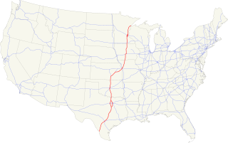
Interstate 35 (I-35) is a major Interstate Highway in the central United States. As with most interstates that end in a five, it is a major cross-country, north-south route stretching from Laredo, Texas, near the Mexican-American border to Duluth, Minnesota, at Minnesota Highway 61 and 26th Avenue East. The highway splits into Interstate 35E and Interstate 35W in two separate places, the Dallas–Fort Worth metroplex in Texas and at the Minnesota twin cities of Minneapolis–Saint Paul.
Interstate 45 (I-45) is an Interstate Highway located entirely within the U.S. state of Texas. While most Interstate routes ending in "5" are cross-country north-south routes, I-45 is comparatively short, with the entire route located in Texas. It connects the cities of Dallas and Houston, continuing southeast from Houston to Galveston over the Galveston Causeway to the Gulf of Mexico.

Medical/Market Center station is a Trinity Railway Express commuter rail station in Dallas, Texas. It is located at Motor Street and Medical Center Drive along the Stemmons Corridor in North Dallas. It opened on December 30, 1996 and serves Dallas Market Center and the nearby medical district which includes Parkland Memorial Hospital, Children's Medical Center of Dallas, University of Texas Southwestern Medical Center, St. Paul Medical Center and Zale Lipshy University Hospital.

The Kansas City metropolitan area is a 15 county metropolitan area anchored by Kansas City, Missouri, and straddling the border between the U.S. states of Missouri and Kansas. With a population of 2,104,509, it ranks as the second largest metropolitan area centered in Missouri. Alongside Kansas City, the area includes a number of other cities and suburbs, the largest being Overland Park, Kansas; Kansas City, Kansas; Olathe, Kansas; and Independence, Missouri; each over 100,000 in population. The Mid-America Regional Council (MARC) serves as the Council of Governments and the Metropolitan Planning Organization for the area.

Oak Lawn is a neighborhood in Dallas, Texas (USA), defined in Dallas City Ordinance 21859 as Planned Development District No. 193, the Oak Lawn Special Purpose District. The unofficial boundaries are Turtle Creek Boulevard, Central Expressway, the City of Highland Park, Inwood Road, and Harry Hines Boulevard. It is over 12 square miles (31 km2) in area. Officially it is bounded by the City of Highland Park, the North Central Expressway, Stemmons Freeway, Woodall Rodgers Freeway, and other roads. The district is within the boundary defined by the City of Dallas law, excluding any existing planned development districts within.

Loop 12 is a state highway that runs mostly within the city limits of Dallas, Texas. The western segment of the loop is named after General Walton Walker, who served and died in South Korea. During the 1950s and 1960s, Loop 12 was the outer beltway in the Dallas area, having since been supplanted by Interstate 635, which is itself being supplanted by the President George Bush Turnpike. Loop 12 is, however, the only state highway in Dallas that forms a complete loop.

The Dallas North Tollway is a 30.2-mile (49 km) controlled-access toll road operated by the North Texas Tollway Authority (NTTA), which runs from Interstate 35E near downtown Dallas, Texas (USA), to U.S. Highway 380, in Frisco, Texas.
Interstate 635 (I-635) is a 37-mile-long (60 km) partial loop around Dallas, Texas, in the United States between I-20 in Balch Springs and State Highway 121 (SH 121) at the north entrance of the Dallas-Fort Worth International Airport in Grapevine. It intersects I-35E at exits 27B–C, but does not connect with I-35W. Portions of I-635 and I-20 are collectively designated as the Lyndon B. Johnson Freeway; known locally as the LBJ Freeway, or simply LBJ. The roadway is named after Lyndon B. Johnson, the former U.S. Senator from Texas, 37th Vice President, and the 36th President of the United States.

Spur 366, also named Woodall Rodgers Freeway, is a highway that connects Beckley Avenue and Singleton Boulevard in West Dallas to Interstate 35E and U.S. Highway 75 in central Dallas, Texas. The highway, as part of the downtown freeway loop, also serves as a dividing line between downtown Dallas on the south and the Uptown and Victory Park neighborhoods on the north.
Central Expressway is a north–south highway in Dallas, Texas (USA) and surrounding areas. The best-known section is the North Central Expressway, a name for a freeway section of U.S. Highway 75 between downtown Dallas and McKinney, Texas. The southern terminus is at an intersection with "hidden" Interstate 345 and Woodall Rodgers Expressway. From south of Main Street and its crossing under the Interstate 45 overhead in downtown Dallas, Central Expressway became the South Central Expressway, renamed César Chávez Boulevard on April 9, 2010.

Interstate 35E (I-35E), an Interstate Highway, is the eastern half of I-35 where it splits to serve the Dallas/Fort Worth metropolitan area. I-35 splits into two branch routes, I-35W and I-35E at Hillsboro. I-35E travels northward for 97 miles (156 km), maintaining I-35's sequence of exit numbers. It travels through Dallas before rejoining with I-35W to reform I-35 in Denton. This is one of two pairs of suffixed Interstates that has not been eliminated; I-35 also splits into I-35E and I-35W in Minneapolis–Saint Paul, Minnesota.
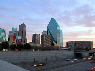
This article is about transportation systems in and around Dallas, Texas (USA).
Interstate 10 (I-10) is the major east–west Interstate Highway in the Southern United States. In the U.S. state of Texas, it runs east from Anthony, at the border with New Mexico, through El Paso, San Antonio and Houston to the border with Louisiana in Orange, Texas. At just under 880 miles (1,420 km), the Texas segment of I-10, maintained by the Texas Department of Transportation, is the longest continuous untolled freeway in North America that is operated by a single authority,. It is also the longest stretch of highway with a single designation within a single state. Mile marker 880 and its corresponding exit number in Orange, Texas, are the highest numbered mile marker and exit on any freeway in North America. After widening was completed in 2008, a portion of the highway west of Houston is now also believed to be the widest in the world, at 26 lanes. There is a wider section in China on the G4 Beijing–Hong Kong–Macau Expressway; however, that section is a toll plaza approach.
Interstate 35 in Texas is a major north–south Interstate Highway running from Laredo near the United States-Mexico border to the Red River north of Gainesville where it crosses into Oklahoma. Along its route, it passes through the cities of San Antonio, Austin, and Waco before it splits into two auxiliary routes just north of Hillsboro. Interstate 35E heads northeast where it passes through Dallas. Interstate 35W turns northwest to run through Fort Worth. The two branches meet up in Denton to again form Interstate 35, where it continues to the Oklahoma border. The exit numbers for Interstate 35E maintain the sequence of exit numbers from the southern segment of Interstate 35, and the northern segment of Interstate 35 follows on from the sequence of exit numbers from Interstate 35E. Interstate 35W maintains its own sequence of exit numbers.

The Trinity Strand Trail is a proposed 7.8-mile, hike/bike commuter and recreational trail that will run along the course of the original Trinity River in Dallas, Texas (USA), also known as Old Meanders. This part of the Trinity River flows through the heart of the Dallas Design District. Trinity Strand Trail plays a key part in the vision for the Old Trinity River corridor. It will provide a great recreational resource for the area and will also connect to Katy Trail, the Southwestern Medical District, Dallas Market Center and several residential and commercial properties.

North Dallas is an area of numerous communities and neighborhoods in Dallas, Texas. The phrase "North Dallas" is also sometimes used to include any suburb or exurb north of Dallas proper within the metropolitan area. The majority of North Dallas is located in Dallas County, while a small portion is located in Collin and Denton Counties. North Dallas generally includes areas of Dallas north of Northwest Highway, along with Lake Highlands and areas of Dallas north of IH-635 known as Far North Dallas. The area has strong social and economic ties to the Dallas enclave of Park Cities, and two inner suburbs of Dallas, Richardson and Addison. It is the wealthiest part of Dallas, but has its adjacent, less resourced areas as well.


