Stenhouse, Edinburgh

Last updated

Stenhouse Mansion Stenhouse, Edinburgh.jpg
Stenhouse Mansion
An aerial view of Ford's Road, a typical Stenhouse street

Stenhouse is a suburb of Edinburgh, the capital of Scotland. It lies to the west of the City Centre, adjacent to Whitson and Saughton Mains and close to Broomhouse and Chesser. It is a mainly residential area.

Contents

The area derives its name from the Stanhope or Stenhope family who held land and mills near the Water of Leith from 1511 to 1621. [1] Early references are variously to Stennop Milne (1576), Stanehope mylnes (1578), Stanehopps (1585), Stenhopmilne (1630) until, in 1773, the name Stenhouse Mill appears. [2]

The oldest building, now known as Stenhouse Mansion, lies to the south of the area. The house was probably originally built by the Stenhopes but it was substantially rebuilt and extended by Patrick Ellis, an Edinburgh burgess and merchant, in 1623 according to the datestone over the main entrance with his initials and the Ellis heraldry, as described by George Mackenzie. [3] It was restored in 1964 and used as a centre for conservation of paintings and carved stones for Historic Scotland until 2009 and now is maintained by the National Trust for Scotland. [4]

Around five hundred houses were built at Stenhouse between 1930 and 1936 by the City Architect Ebenezer MacRae, mainly flatted blocks, but with a few tenements.From November 1953, 287 (4th Edinburgh) Squadron, of the Air Training Corps, was based at its drill hall in the extreme north-west of Stenhouse, next to the Edinburgh/Glasgow railway line. In 2008, the Squadron was forced to move to make way for the Edinburgh Trams line but it relocated to new premises on Stevenson Drive, adjacent to Saughton Enclosure, in 2010. In recognition of its connection with Stenhouse, the Squadron was renamed 287 (Stenhouse) Squadron in 2012.

Another part of Edinburgh – a hamlet east of Liberton now referred to as Ellen's Glen [5] – was once also known as Stenhouse probably after an ancient stone-built house in the area. [6]

Transport

Lothian Buses services 1,2,22 and night bus N22 pass through the area while services 3,25,30,33,35,300 and night services N25 and N30 travel along Stenhouse Road on the southern edge. The nearest trams stops are Saughton and Balgreen.

Notable residents

Related Research Articles

<span class="mw-page-title-main">Newington, Edinburgh</span> Human settlement in Scotland

Newington is a neighbourhood of southern Edinburgh, Scotland. Developed from the early 19th century, it is an affluent, predominantly residential area.

<span class="mw-page-title-main">Balerno</span> Human settlement in Scotland

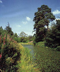
Balerno is a village on the outskirts of Edinburgh, Scotland situated 8 miles south-west of the city centre, next to Currie and then Juniper Green. Traditionally in the county of Midlothian it now administratively falls within the jurisdiction of the City of Edinburgh Council. The village lies at the confluence of the Water of Leith and the Bavelaw Burn. In the 18th and 19th century, the area was home to several mills using waterpower. In the 20th century, the mills closed and the village now forms a residential suburb of Edinburgh.

<span class="mw-page-title-main">Cameron Toll</span> Suburb in the South of Edinburgh

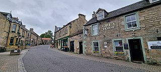
Cameron Toll is a suburb located to the south of Edinburgh, Scotland. Originally it was the site of a toll house built in the early 19th century, which was located on a stretch of road between Edinburgh and Dalkeith. Today the area is home to Cameron Toll Shopping Centre, which opened in 1984. The meaning of the name Cameron is suggested to be 'crooked hill', derived from the Scots Gaelic 'cam', crooked, and Old Irish 'brun' meaning hill, believed to refer to Arthur's Seat clearly visible nearby; the original name may have been Pictish. There are a few small housing estates to the east of the area.

<span class="mw-page-title-main">Saughton</span> Human settlement in Scotland

Saughton is a suburb of the west of Edinburgh, Scotland, bordering Broomhouse, Stenhouse, Longstone and Carrick Knowe. In Lowland Scots, a "sauch" is a willow. The Water of Leith flows by here.

<span class="mw-page-title-main">Longstone, Edinburgh</span> Human settlement in Scotland

Longstone is a suburb of Edinburgh in Scotland. The area is primarily residential in nature, although the area includes several small shops, eateries and supermarkets, as well as one of the main bus depots for the city's buses. The population of Longstone was 4,678 in 2019.

<span class="mw-page-title-main">Mortonhall</span> Area of Edinburgh, Scotland

Mortonhall is an area of Edinburgh, Scotland, on the south edge of the city.

<span class="mw-page-title-main">Broomhouse, Edinburgh</span> Human settlement in Scotland

Broomhouse is a district of Edinburgh, Scotland. Although on the lands of Old Saughton, its name is adopted from an estate which lay to the north of the Edinburgh and Glasgow Railway. The earliest recorded versions of the name (c.1600) were variations on Brum(e)hous. It mainly comprises a low-rise council housing estate built between 1947 and 1950. It borders on Parkhead, Sighthill, and Saughton Mains. The arterial route of Calder Road (A71) passes to the south.

<span class="mw-page-title-main">Cammo</span>

Cammo is a northwestern suburb of Edinburgh, the capital of Scotland. It is south of A90, at the edge of the city, approximately 6 miles from the city centre.

<span class="mw-page-title-main">Liberton, Edinburgh</span> Human settlement in Scotland

Liberton is a suburb of Edinburgh, the capital of Scotland. It is in the south of the city, south of The Inch, east of the Braid Hills and west of Moredun.

<span class="mw-page-title-main">Moredun</span>

Moredun is a district in the south-east of Edinburgh, the capital of Scotland. It is east of Liberton, while Craigour is situated just to its north.

<span class="mw-page-title-main">Pilrig</span> Suburb of Edinburgh, Scotland

Pilrig is an area of Edinburgh, the capital of Scotland. The name probably derives from the long field (rig) on which a peel tower (pil/peel) stood. There is evidence of a peel tower situated on an area of higher ground above the Water of Leith.

Carrick Knowe is a suburb in the west of Edinburgh in Scotland, located approximately 3 miles from the city centre. It is bordered by Tyler's Acre to the north, the Glasgow/Aberdeen railway line to the south, Carrick Knowe Golf Course to the east, and Saughton Road North to the west. The catchment area for the primary school encompasses this entire area. It is often considered part of Corstorphine, however it has its own shopping areas, primary school, parish church and public park.

Silvermills, once an ancient village, has been part of Edinburgh since 1809.

<span class="mw-page-title-main">Ellen's Glen House</span> Hospital in Edinburgh, Scotland

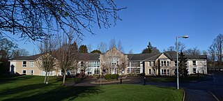
Ellen's Glen House is a facility providing services to elderly and mentally ill patients in Liberton, Edinburgh, Scotland. It is managed by NHS Lothian.

<span class="mw-page-title-main">Ebenezer James MacRae</span> Scottish architect (1881–1951)

Ebenezer James MacRae was a Scottish architect serving as City Architect for Edinburgh for most of his active life.

Stenhouse Stadium was a greyhound racing track and trotting track in Edinburgh.

<span class="mw-page-title-main">Southfield Sanatorium</span> Historic hospital in Liberton, Edinburgh

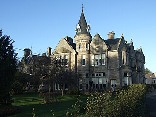
Southfield Sanatorium was a specialist historic hospital in Liberton, Edinburgh, Scotland, situated near Ellen's Glen nature reserve. The house was redeveloped to provide private residences, new housing was built in the grounds and a purpose-built health facility opened at Ellen's Glen in 2000.

<span class="mw-page-title-main">Gracemount</span> Human settlement in Scotland

Gracemount is a neighbourhood in the south of Edinburgh, Scotland, bordering Alnwickhill and Kaimes to the west, Liberton to the north, Gilmerton to the east and Southhouse to the south.

References

  1. "The Derivation of Edinburgh's Street Names". Archived from the original on 1 August 2013. Retrieved 7 September 2013.
  2. Dixon, Norman. "Place Names of Midlothian" (PDF). Archived from the original (PDF) on 27 August 2011. Retrieved 7 September 2013.
  3. Alexander Nisbet, A System of Heraldry, vol. 1 (Edinburgh, 1722), p. 26.
  4. Michael Bath, Anne Crone, Michael Pearce, The Dendrochronology and Art History of 16th and 17th century Painted Ceilings (Historic Environment Scotland, 2017), p. 7: Carol Brown, in Belinda Colston & David Watt, Conservation of Historic Buildings and Their Contents (Routledge, 2015), pp. 31-33.
  5. Ellen's Glen (Stenhouse), Gazetteer for Scotland
  6. Aboon the Kirk | Interesting places in Liberton [parts 10-12], The Liberton Association, 2020

Sources

55°55′57.85″N3°15′36.91″W / 55.9327361°N 3.2602528°W / 55.9327361; -3.2602528