
Norfolk County is located in the U.S. state of Massachusetts. At the 2020 census, the population was 725,981. Its county seat is Dedham. It is the fourth most populous county in the United States whose county seat is neither a city nor a borough, and it is the second most populous county that has a county seat at a town. The county was named after the English county of the same name. Two towns, Cohasset and Brookline, are exclaves.

Suffolk County is located in the Commonwealth of Massachusetts, in the United States. As of the 2020 census, the population was 797,936, making it the fourth-most populous county in Massachusetts. The county comprises the cities of Boston, Chelsea, Revere, and Winthrop. The traditional county seat is Boston, the state capital and the largest city in Massachusetts. The county government was abolished in 1999, and so Suffolk County today functions only as an administrative subdivision of state government and a set of communities grouped together for some statistical purposes. Suffolk County is located at the core of the Boston-Cambridge-Newton, MA-NH Metropolitan Statistical Area as well as the greater Boston-Worcester-Providence, MA-RI-NH-CT Combined Statistical Area.

Foxborough is a town in Norfolk County, Massachusetts, United States, about 22 miles (35 km) southwest of Boston, 18 miles (29 km) northeast of Providence, Rhode Island and about 40 miles (64 km) northwest of Cape Cod. The population was 18,618 at the 2020 census.

Sharon is a New England town in Norfolk County, Massachusetts, United States. The population was 18,575 at the 2020 census. Sharon is part of Greater Boston, about 17 miles (27 km) southwest of downtown Boston, and is connected to both Boston and Providence by the Providence/Stoughton Line.

Forest Hills Cemetery is a historic 275-acre (111.3 ha) rural cemetery, greenspace, arboretum, and sculpture garden in the Forest Hills section of Jamaica Plain, a neighborhood in Boston, Massachusetts. The cemetery was established in 1848 as a public municipal cemetery for Roxbury, Massachusetts, but was privatized when Roxbury was annexed to Boston in 1868.

This is a list of properties and districts in Massachusetts listed on the National Register of Historic Places. There are over 4,300 listings in the state, representing about 5% of all NRHP listings nationwide and the second-most of any U.S. state, behind only New York. Listings appear in all 14 Massachusetts counties.
This is a list of properties and historic districts listed on the National Register of Historic Places in Norfolk County, Massachusetts, other than those within the city of Quincy and the towns of Brookline and Milton. Norfolk County contains more than 300 listings, of which the more than 100 not in the above three communities are listed below. Some listings extend across municipal boundaries, and appear on more than one list.
North Quincy is a neighborhood of Quincy, Massachusetts. It is separated from the city of Boston by the Neponset River, and borders the Quincy neighborhoods of Squantum, Montclair and Wollaston. It contains the smaller neighborhoods of Atlantic and Norfolk Downs, as well as much of Wollaston Beach.

The Colburn School–High Street Historic District is a linear historic district encompassing the village center of Westwood, Massachusetts. It extends along High Street roughly between Conant Street in the north and Gay Street in the south. It is largely residential in character, with 37 houses, most of which date from the 18th to the mid-19th centuries. The rural character of the area is captured by a number of preserved 19th-century barns. The district also includes Westwood Town Hall, a 1910 Classical Revival building, and the 1874 Second Empire Colburn School. The school was named for Warren and Dana P. Colburn who both attended the school. They authored a book on arithmetic. Prior to being named for them in March 1867, it was known as the Clapboardtrees School, the West Dedham School and District Number Eight.
South Valley is a neighborhood on the South side of Syracuse, New York. It features Meachem Elementary School, Clary Middle School, Betts Branch library, Webster's Pond, and the Redmond family.
The Norfolk County Courthouse, also known as the William D. Delahunt courthouse, is a National Historic Landmark at 650 High Street in Dedham, Massachusetts. It currently houses the Norfolk County Superior Court. It is significant as a well-preserved Greek Revival courthouse of the 1820s, and as the site a century later of the famous Sacco-Vanzetti trial. The building was declared a National Historic Landmark in 1972, and is listed on the National Register of Historic Places. It replaced an earlier courthouse, built in 1795.

The Foxboro Grange Hall is a historic Grange building at 11–15 Bird Street in Foxborough, Massachusetts. It is a three-story wood-frame structure, five bays wide at the upper levels and three storefronts wide on the first level, with a hip roof and clapboard siding. Built in 1897, it is one of few wood-frame commercial buildings in the town, and is a reminder of the town's agricultural past for its historic use as a Grange hall. The first floor has been adapted for retail use.
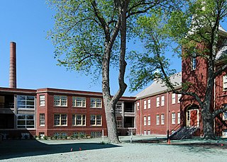
Foxborough State Hospital, historically known as the Massachusetts Hospital for Dipsomaniacs and Inebriates, is a historic medical treatment facility at the junction of Chestnut and Main Streets in Foxborough, Massachusetts. The creation of an alcohol abuse treatment facility was authorized by state legislation in 1889, and the Foxborough campus was developed in the 1890s. The original campus consisted of a series of residential wards in an L shape, with an administration building at the center, and a variety of ancillary support buildings on the grounds. Problems with the facility, including its location, prompted the state to move the substance abuse facility in 1914 to a new campus in Norfolk. The Foxborough campus was then adapted for use as a standard mental hospital. The surviving 19th-century elements of the campus were listed on the National Register of Historic Places in 1994.

The Ezra Carpenter House is a historic house at 168 South Street in Foxborough, Massachusetts. The 1+1⁄2-story Cape style house was built in 1800 by Ezra Carpenter, a veteran of the American Revolutionary War. Later generations of Carpenters also played significant roles in the civic life of the town. The main block of the house is five bays wide, with a centered entry, and an original central chimney. The ell to the right is a later 19th century addition.

The Foxborough Pumping Station is a historic water pumping station at 25 Pumping Station Road in Foxborough, Massachusetts. Its main pumphouse was designed by Ernest N. Boyden, a regionally known architect of water supply systems, and was built in 1891; it is a brick structure with Queen Anne styling. The station also includes several historic wells, a period garage, and the man-made Fales Pond, a once-dammed section of the Neponset Reservoir near the pumphouse. The station was listed on the National Register of Historic Places in 2005.
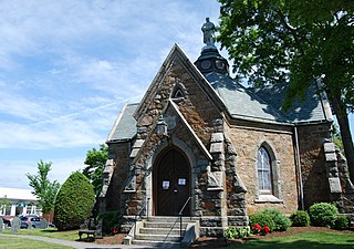
Memorial Hall is a historic Grand Army of the Republic hall at 22 South Street in Foxborough, Massachusetts, United States. It is a single-story granite Gothic Revival structure, octagonal in shape, with four projecting wings and a turret capped by a statue of a Union Army soldier.

Fort Lee is a historic American Revolutionary War fort in Salem, Massachusetts. The site, located at a high point next to Fort Avenue on Salem Neck, is a relatively rare fortification from that period whose remains are relatively unaltered. It is an irregular 5-pointed star fort. Although there is some documentary evidence that the Neck was fortified as early as the 17th century, the earthworks built in 1776 are the first clear evidence of the site's military use. Reportedly, the fort had a garrison of 3 officers and 100 artillerymen with 16 guns. The site, of which only overgrown earthworks and a stone magazine survive, was repaired in the 1790s, and rebuilt for the American Civil War. A state cultural resource document states that the fort has not been much modified since the Revolution, and has not been built over. It was garrisoned by the Massachusetts militia in the War of 1812, abandoned afterwards, and rebuilt with four 8-inch columbiads in the Civil War. An Army engineer drawing dated 1872 depicts the fort's five-pointed trace and the four Civil War gun positions. It was also garrisoned during the Spanish–American War.

The Cheshire County Courthouse, located at 12 Court Street in Keene, New Hampshire, is the center of government of Cheshire County, New Hampshire. Completed in 1859 to a design by Gridley James Fox Bryant, it is believed to be the oldest courthouse in regular use in the state. It was added to the National Register of Historic Places on December 13, 1978.
The Samuel Dexter House is a historic house at 699 High Street, Dedham, Massachusetts. It was built, beginning in July 1761, by Samuel Dexter, a member of the Massachusetts Provincial Congress.


