
Gifu Prefecture is a prefecture of Japan located in the Chūbu region of Honshu. Gifu Prefecture has a population of 1,991,390 and has a geographic area of 10,621 square kilometres (4,101 sq mi). Gifu Prefecture borders Toyama Prefecture to the north; Ishikawa Prefecture to the northwest, Fukui Prefecture and Shiga Prefecture to the west, Mie Prefecture to the southwest, Aichi Prefecture to the south, and Nagano Prefecture to the east.

Nakatsugawa is a city located in Gifu, Japan. As of 31 December 2018, the city had an estimated population of 78,930, and a population density of 120 persons per km2 in 30,788 households The total area of the city was 676.45 square kilometres (261.18 sq mi).

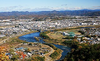
Mizunami is a city located in Gifu, Japan. As of 1 January 2019, the city had an estimated population of 37,705, and a population density of 220 persons per km2. The total area of the city was 174.86 square kilometres (67.51 sq mi). Mizunami's biggest claim to fame came in 1995, when the largest ceramic plate in the world, as recognised by the Guinness Book of Records, was created by the Inatsu Town Planning Association in the city. It measures 2.8 metres in diameter.

Ena is a city located in Gifu, Japan. As of 1 June 2019, the city had an estimated population of 48,777, and a population density of 96.7 persons per km2, in 19,820 households. The total area of the city was 504.24 square kilometres (194.69 sq mi).
Minokamo is a city located in Gifu, Japan. As of 1 January 2019, the city had an estimated population of 56,972 and a population density of 74.81 persons per km2, in 22,508 households. The total area of the city was 74.81 square kilometres (28.88 sq mi).

Toki is a city located in Gifu, Japan. As of 31 January 2018, the city had an estimated population of 58,567 in 24,485 households, and a population density of 500 persons per km2. The total area of the city was 117.01 square kilometres (45.18 sq mi). Toki is known as one of the largest producers of Japanese pottery, generally referred to as Mino ware.

Kani is a city located in Gifu, Japan. As of 1 April 2024, the city had an estimated population of 99,826 and a population density of 1100 persons per km2, in 42,286 households. The total area of the city was 87.57 square kilometres (33.81 sq mi).
Seto is a city in Aichi Prefecture, Japan. As of 1 October 2019, the city had an estimated population of 127,659 in 56,573 households, and a population density of 1,146 persons per km2. The total area was 111.40 square kilometres (43.01 sq mi).

Kasugai is a city in Aichi Prefecture, Japan. As of 1 October 2019, the city had an estimated population of 306,764, and a population density of 3,306 persons per km2. The total area of the city is 92.78 square kilometres (35.82 sq mi). The city is sometimes called Owarikasugai to avoid confusion with other municipality of the same name, including Kasugai in Yamanashi Prefecture.

Inuyama is a city in Aichi Prefecture, Japan. As of 1 October 2019, the city had an estimated population of 73,420 in 31,276 households, and a population density of 980 persons per km2. The total area of the city is 74.90 square kilometres (28.92 sq mi). The name of the city literally translates to "Dog Mountain". The name appears in historical records from 1336 AD, but its origin is unknown.
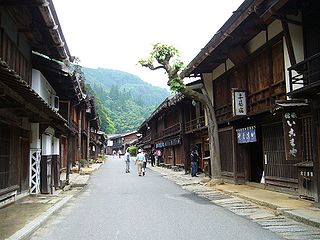
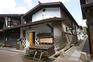
Nagiso is a town located in Nagano Prefecture, Japan. As of 1 April 2019, the town had an estimated population of 4,111 in 1751 households, and a population density of 19 persons per km2. The total area of the town was 215.93 square kilometres (83.37 sq mi). Nagiso is listed as one of The Most Beautiful Villages in Japan.

Aisai is a city located in Aichi Prefecture, Japan. As of 1 October 2019, the city had an estimated population of 61,320 in 23,451 households, and a population density of 919 persons per km2. The total area of the city is 66.70 square kilometres (25.75 sq mi). Aisai is a member of the World Health Organization’s Alliance for Healthy Cities (AFHC).

Chūkyō, or the Chūkyō region, is a major metropolitan area in Japan that is centered on the city of Nagoya in Aichi Prefecture. The area makes up the most urbanized part of the Tōkai region. The population of 10,110,000 over an area of 7,072 square kilometers. Nevertheless, like most of Japan's major metro areas, the core of it lies on a fertile alluvial plain, in this case, the Nōbi Plain.

Tōnō (東濃) is the southeastern portion of Gifu Prefecture in the Chūbu region of Japan. The Tōnō region received its name as a combination of the kanji for "east" (東) and "Mino" (美濃). The borders of this region are not officially set, but it generally consists of the following cities: Tajimi, Toki, Mizunami, Ena and Nakatsugawa. Occasionally, Kani, usually part of the Chūnō region, is also included as being part of Tōnō.

Mitoyo is a city located in Kagawa Prefecture, Japan. As of 31 September 2022, the city had an estimated population of 59,876 in 23024 households and a population density of 270 persons per km2. The total area of the city is 222.73 square kilometres (86.00 sq mi).
Kiso is a town located in Nagano Prefecture, Japan. As of 5 April 2019, the town had an estimated population of 11,045 in 4892 households, and a population density of 23 persons per km2. The total area of the town is 476.03 square kilometres (183.80 sq mi). Kiso Town is listed as one of The Most Beautiful Villages in Japan.
National Route 19 is a national highway connecting Nagoya and Nagano in Japan.

The Shōnai River is a Class 1 river flowing through Gifu and Aichi prefectures in Japan. In Gifu Prefecture, it is also referred to as the Toki River ; around the city of Kasugai in Aichi Prefecture, it is referred to as the Tamano River. Fujimae-higata exists in the River mouth.

Agigawa Dam is a dam built on the Kiso River system, located in the Higashino section of Ena City, in Gifu Prefecture, Japan.
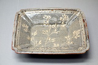
Mino ware is a style of Japanese pottery, stoneware, and ceramics that is produced in Mino Province, mainly in the cities of Tajimi, Toki, Mizunami, and Kani in Gifu Prefecture, central Japan.


