Taketa, Ōita

Last updated • 3 min readFrom Wikipedia, The Free Encyclopedia
Taketa
竹田市
Okajoshi.jpg
Flag of Taketa, Oita.svg
Emblem of Taketa, Oita.svg
Taketa, Oita
Location of Taketa in Ōita Prefecture
Taketa in Oita Prefecture Ja.svg
Japan location map with side map of the Ryukyu Islands.svg
Red pog.svg
Taketa
Location in Japan
Coordinates: 32°58′25″N131°23′52″E / 32.97361°N 131.39778°E / 32.97361; 131.39778
CountryJapan
Region Kyushu
Prefecture Ōita
Government
  Mayor Masahiro Doi (since April 2021)
Area
  Total
477.53 km2 (184.38 sq mi)
Population
 (November 30, 2023)
  Total
19,456
  Density41/km2 (110/sq mi)
Time zone UTC+09:00 (JST)
City hall addressOji-Aiai 1650, Taketa-shi, Ōita-ken 878-8555
Climate Cfa
Website Official website
Symbols
Bird Cettia diphone
Flower Kyushu Azelea
Tree Maple
Taketa City Hall Taketa city office.jpg
Taketa City Hall

Taketa (竹田市, Taketa-shi) is a city located in Ōita Prefecture, Japan. As of 3 November 2023, the city had an estimated population of 19,456 in 9838 households, and a population density of 41 persons per km2. [1] The total area of the city is 477.53 km2 (184.38 sq mi).

Contents

Geography

Taketa is located in the southwestern part of Ōita Prefecture. The city center is approximately 55 km southwest of the prefectural capital at Ōita City and approximately 73 km east-northeast of Kumamoto City. The city is surrounded by mountains reaching heights of approximately 1 km, such as the Kujū Mountain Range, Mount Aso, Mount Sobo, and Mt. Takayama, and natural beauty spots include Takeda Springs and Kujū Plateau. Together with Bungo-Ōno City, which adjoins it to the east, it is known as the "Hōhi district" (or "Oku-Bungo"). Although Taketa borders Miyazaki Prefecture to the south, there is no direct road connection to Miyazaki from Taketa.

Neighboring municipalities

Kumamoto Prefecture

Miyazaki Prefecture

Ōita Prefecture

Climate

Taketa has a humid subtropical climate (Köppen climate classification Cfa) with hot summers and cool winters. Precipitation is significant throughout the year, but is somewhat lower in winter. The average annual temperature in Taketa is 14.7 °C (58.5 °F). The average annual rainfall is 1,885.3 mm (74.22 in) and June is the wettest month. The temperatures are highest on average in August, at around 25.7 °C (78.3 °F), and lowest in January, at around 3.9 °C (39.0 °F). [2] The highest temperature ever recorded in Taketa was 37.7 °C (99.9 °F) on 15 August 2020; the coldest temperature ever recorded was −8.6 °C (16.5 °F) on 10 February 1984. [3]

Climate data for Taketa (1991−2020 normals, extremes 1977−present)
MonthJanFebMarAprMayJunJulAugSepOctNovDecYear
Record high °C (°F)20.8
(69.4)
25.0
(77.0)
28.0
(82.4)
29.8
(85.6)
35.0
(95.0)
33.9
(93.0)
36.9
(98.4)
38.1
(100.6)
35.2
(95.4)
31.7
(89.1)
27.3
(81.1)
23.5
(74.3)
38.1
(100.6)
Mean daily maximum °C (°F)9.0
(48.2)
10.6
(51.1)
14.4
(57.9)
19.9
(67.8)
24.3
(75.7)
26.1
(79.0)
30.4
(86.7)
31.1
(88.0)
27.2
(81.0)
22.1
(71.8)
16.8
(62.2)
11.3
(52.3)
20.3
(68.5)
Daily mean °C (°F)3.9
(39.0)
5.0
(41.0)
8.4
(47.1)
13.6
(56.5)
18.2
(64.8)
21.3
(70.3)
25.4
(77.7)
25.7
(78.3)
22.0
(71.6)
16.5
(61.7)
11.0
(51.8)
5.8
(42.4)
14.7
(58.5)
Mean daily minimum °C (°F)−0.9
(30.4)
−0.3
(31.5)
2.7
(36.9)
7.5
(45.5)
12.6
(54.7)
17.4
(63.3)
21.7
(71.1)
21.7
(71.1)
17.9
(64.2)
11.5
(52.7)
5.6
(42.1)
0.7
(33.3)
9.8
(49.7)
Record low °C (°F)−8.4
(16.9)
−8.6
(16.5)
−7.2
(19.0)
−3.2
(26.2)
1.2
(34.2)
7.7
(45.9)
12.1
(53.8)
13.8
(56.8)
5.5
(41.9)
0.2
(32.4)
−3.4
(25.9)
−8.2
(17.2)
−8.6
(16.5)
Average precipitation mm (inches)48.1
(1.89)
67.4
(2.65)
103.6
(4.08)
117.7
(4.63)
147.8
(5.82)
364.9
(14.37)
309.7
(12.19)
221.0
(8.70)
268.6
(10.57)
124.1
(4.89)
67.6
(2.66)
45.0
(1.77)
1,885.3
(74.22)
Average precipitation days (≥ 1.0 mm)5.87.910.110.09.815.013.111.810.97.46.95.8114.5
Mean monthly sunshine hours 159.9151.3170.3188.1194.9131.7174.2193.5144.8165.6153.8160.61,988.6
Source: Japan Meteorological Agency [3] [2]

Demographics

Per Japanese census data, the population of Taketa in 2020 is 20,332 people. [4] Taketa has been conducting censuses since 1920.

Historical population
YearPop.±%
1960 56,889    
1965 49,308−13.3%
1970 42,873−13.1%
1975 38,359−10.5%
1980 36,011−6.1%
1985 34,693−3.7%
1990 32,398−6.6%
1995 30,368−6.3%
2000 28,689−5.5%
2005 26,534−7.5%
2010 24,361−8.2%
2015 22,332−8.3%
2020 20,332−9.0%
Taketa population statistics [4]

History

The area of Taketa was part of ancient Bungo Province and roughly corresponds to Naoiri District, one of the eight counties of Bungo mentioned in the Nara period Bungo no Kuni Fudoki. During the Edo period it developed as the castle town of Oka Domain and was ruled by the Nakagawa clan until the Meiji restoration. Following the Meiji restoration, the town of Saeki within Naoiri District, Ōita was established on May 1, 1889 with the creation of the modern municipalities system. The city was founded on 31 March 1954. On 1 April 2005, the towns of Kujū, Naoiri and Ogi (all from Naoiri District) were also merged into Taketa.

Government

Taketa has a mayor-council form of government with a directly elected mayor and a unicameral city council of 15 members. Taketa contributes one member to the Ōita Prefectural Assembly. In terms of national politics, the city is part of the Ōita 2nd district of the lower house of the Diet of Japan.

Economy

The economy of Taketa is centered around agriculture and forestry. The main crops are kabosu , shiitake , tomatoes and sweet corn.

Education

Takata has 11 public elementary schools and four public junior high schools operated by the city government. The city has two public high schools operated by the Ōita Prefectural Board of Education and one private high school. The prefecture operates one special education school for students with disabilities.

Transportation

Railways

JR logo (west).svg JR Kyushu - Hōhi Main Line

Highways

Sister cities

Local attractions

Traditional crafts

Princess Daruma dolls (姫だるま, Hime Daruma) were first created and remain a popular local craft in Taketa. [5]

Taketa Princess Daruma Doll Himedaruma taketa.jpg
Taketa Princess Daruma Doll

Notable people from Taketa

Related Research Articles

<span class="mw-page-title-main">Ōita Prefecture</span> Prefecture of Japan

Ōita Prefecture is a prefecture of Japan located on the island of Kyūshū. Ōita Prefecture has a population of 1,136,245 and has a geographic area of 6,340 km2. Ōita Prefecture borders Fukuoka Prefecture to the northwest, Kumamoto Prefecture to the southwest, and Miyazaki Prefecture to the south.

<span class="mw-page-title-main">Saiki, Ōita</span> City in Ōita Prefecture, Japan

Saiki is a city located in Ōita Prefecture, Japan. As of 31 October 2023, the city had an estimated population of 65,870 in 32921 households, and a population density of 73 persons per km2. The total area of the city is 903.11 km2 (348.69 sq mi), making it the largest city by area in Kyushu.

<span class="mw-page-title-main">Takachiho, Miyazaki</span> Town in Kyushu, Japan

Takachiho is a town in Nishiusuki District, Miyazaki Prefecture, Japan. As of 1 October 2023, the town has an estimated population of 11,065 in 4865 households, and a population density of 47 persons per km2. The total area of the town is 237.54 square kilometres (91.71 sq mi).

Naoiri was a district located in Ōita Prefecture, Japan.

<span class="mw-page-title-main">Kusu, Ōita</span> Town in Kyushu, Japan

Kusu is a town located in Kusu District, Ōita Prefecture, Japan. As of 30 November 2023, the town had an estimated population of 14,085 in 6590 households, and a population density of 49 persons per km2. The total area of the city is 286.51 km2 (110.62 sq mi)

<span class="mw-page-title-main">Aso, Kumamoto</span> City in Kyushu, Japan

Aso is a city located in Kumamoto Prefecture, Japan. As of 31 July 2024, the city had an estimated population of 24,240 in 11741 households, and a population density of 64 persons per km2. The total area of the city is 376.30 km2 (145.29 sq mi).

<span class="mw-page-title-main">Minamioguni, Kumamoto</span> Town in Kyushu, Japan

Minamioguni is a town located in Aso District, Kumamoto Prefecture, Japan. As of 1 June 2024, the town had an estimated population of 3,831 in 1870 households, and a population density of 33 persons per km2. The total area of the town is 115.90 km2 (44.75 sq mi).

<span class="mw-page-title-main">Ubuyama, Kumamoto</span> Village in Kyushu, Japan

Ubuyama is a village located in Aso District, Kumamoto Prefecture, Japan. As of 15 July 2024, the village had an estimated population of 1,378 in 654 households, and a population density of 23 persons per km2. The total area of the village is 60.81 km2 (23.48 sq mi).

<span class="mw-page-title-main">Takamori, Kumamoto</span> Town in Kyushu, Japan

Takamori is a town located in Aso District, Kumamoto Prefecture, Japan. As of 1 August 2024, the town had an estimated population of 5889 in 2965 households, and a population density of 34 persons per km2. The total area of the town is 175.06 km2 (67.59 sq mi).

<span class="mw-page-title-main">Bungo-Ōno</span> City in Kyushu, Japan

Bungo-Ōno is a city located in Ōita Prefecture, Japan. As of 30 November 2023, the city had an estimated population of 32,846 in 15706 households, and a population density of 54 persons per km2. The total area of the city is 603.13 km2 (232.87 sq mi).

<span class="mw-page-title-main">Yufu</span> City in Kyushu, Japan

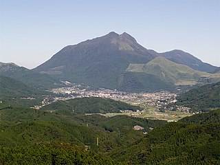
Yufu is a city in Ōita Prefecture. As of 30 November 2023, the city had an estimated population of 33,556 in 15883 households, and a population density of 110 persons per km2. The total area of the city is 319.32 km2 (123.29 sq mi).

National Route 57 is a national highway of Japan connecting Ōita and Nagasaki in Japan.

<span class="mw-page-title-main">Aso Station (Kumamoto)</span> Railway station in Aso, Kumamoto Prefecture, Japan

Aso Station is a passenger railway station located in the city of Aso, Kumamoto, Japan. It Is operated by JR Kyushu.

<span class="mw-page-title-main">Bungo-Taketa Station</span> Railway station in Taketa, Ōita Prefecture, Japan

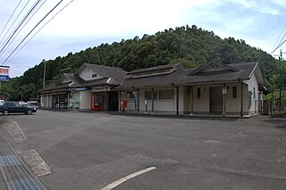
Bungo-Taketa Station is a passenger railway station located in the city of Taketa, Ōita Prefecture, Japan. It is operated by JR Kyushu.

<span class="mw-page-title-main">Miemachi Station</span> Railway station in Bungo-Ōno, Ōita Prefecture, Japan

Miemachi Station is a passenger railway station located in the city of Bungo-Ōno, Ōita Prefecture, Japan. It is operated by JR Kyushu.

<span class="mw-page-title-main">Bungo-Ogi Station</span> Railway station in Taketa, Ōita Prefecture, Japan

Bungo-Ogi Station is a passenger railway station located in the city of Taketa, Ōita Prefecture, Japan. It is operated by JR Kyushu.

<span class="mw-page-title-main">Asaji Station</span> Railway station in Bungo-Ōno, Ōita Prefecture, Japan

Asaji Station is a passenger railway station located in the city of Bungo-Ōno, Ōita Prefecture, Japan. It is operated by JR Kyushu.

<span class="mw-page-title-main">Bungo-Kiyokawa Station</span> Railway station in Bungo-Ōno, Ōita Prefecture, Japan

Bungo-Kiyokawa Station is a passenger railway station located in the city of Bungo-Ōno, Ōita Prefecture, Japan. It is operated by JR Kyushu.

<span class="mw-page-title-main">Bungo Kaidō</span>

The Bungo Kaidō (豊後街道) was a route built during the Edo period in Japan. It started in Kumamoto, Higo Province, and stretched to Ōita, Bungo Province. There were six post stations along the route connecting the two cities.

References

  1. "Taketa City official statistics" (in Japanese). Japan.
  2. 1 2 気象庁 / 平年値(年・月ごとの値). JMA . Retrieved April 23, 2022.
  3. 1 2 観測史上1~10位の値(年間を通じての値). JMA . Retrieved April 23, 2022.
  4. 1 2 Taketa population statistics
  5. "後藤姫だるま工房". Taketa Guide. Retrieved 16 June 2024.