Tempurung Cave

Last updated
Tempurung Cave
Gua Tempurung
Gua Tempurung.jpg
Location Gopeng, Perak, Malaysia

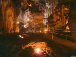
Tempurung Cave is a limestone cave located in Gopeng, Perak, Malaysia, spanning more than 4 kilometers, making it one of the longest caves in Peninsular Malaysia. Its name is taken in conjunction with its shape like a coconut shell. The length of this cave reaches 1.9 km and is believed to have existed since 8000 BC.

The Tempurung Cave consists of five large domes whose ceilings resemble coconut shells, with each dome having a different stalagmite and stalactite shape. Additionally, each dome is different in terms of temperature, water level, and limestone and marble content.

Tempurung Cave is a cave that is the focus of tourists that spans one kilometer from Sungai Siput to Kuala Dipang, and consists of five shell-shaped dome ceilings. It is 4.5 kilometers long, but only 1.9 kilometers of it is accessible to the local public.

Tempurung Cave is located in Gopeng, about 24 kilometers south of Ipoh City. It is also only a 15-minute drive from Sungai Kampar which is also the focus of tourists for kayaking or rafting across the rapids.

In the middle of this cave, there is a stalagmite shaped like a giant.

Since this cave is the focus of tourists, the Perak state government has preserved and conserved this cave area to make it more attractive and tourist-friendly. The cave is now equipped with lights, stairs and bridges, and other public facilities are also provided. For those who like extreme activities, a river cruise in the cave is also held.

In addition to storing natural treasures, this cave is also written in the history of Malaysia. This cave became a communist hideout in the past from 1950 to 1960. While since 1970, Tempurung Cave has been used as a tin mine.

Direction guide

Tempurung Cave can be visited using the North-South Expressway or Federal Road. If you are using PLUS, enter the Gopeng Toll Plaza exit, turn left and continue driving for 2 km until you find the path to Tempurung Cave on the left. This special route was built to allow larger vehicles such as buses to reach the cave. Tempurung Cave's coordinate is 4.4160° N, 101.1877° E.

4°25′N101°11′E / 4.417°N 101.183°E / 4.417; 101.183


Related Research Articles

<span class="mw-page-title-main">Stalactite</span> Elongated mineral formation hanging down from a cave ceiling

A stalactite is a mineral formation that hangs from the ceiling of caves, hot springs, or man-made structures such as bridges and mines. Any material that is soluble and that can be deposited as a colloid, or is in suspension, or is capable of being melted, may form a stalactite. Stalactites may be composed of lava, minerals, mud, peat, pitch, sand, sinter, and amberat. A stalactite is not necessarily a speleothem, though speleothems are the most common form of stalactite because of the abundance of limestone caves.

<span class="mw-page-title-main">Ipoh</span> City and state capital in Perak, Malaysia

Ipoh is the capital city of the Malaysian state of Perak. Located by the Kinta River, it is nearly 200 km (120 mi) north of Kuala Lumpur and 150 km (93 mi) southeast of George Town in neighbouring Penang. As of the 2020 census Ipoh had a population of 759,952, making it the eighth-largest city in Malaysia by population.

<span class="mw-page-title-main">Perlis</span> State of Malaysia

Perlis, also known by its honorific title Perlis Indera Kayangan, is a state of Malaysia in the northwestern coast of Peninsular Malaysia. It is the smallest state in Malaysia by means of area and population, as well as the northernmost in the country. The state borders the Thai provinces of Satun and Songkhla to the north and the Malaysian state of Kedah to the south. Perlis is the only Malaysian state that is not divided into any districts, due to its small size, but it is still divided into several communes. It was called Palit by the Siamese when it was under their influence. Perlis had a population of 227,025 as of the 2010 census.

<span class="mw-page-title-main">Gopeng</span> Town in Perak, Malaysia

Gopeng is a town located in Mukim Teja, Kampar District, Perak, Malaysia. It is situated approximately 20 km (12 mi) south of Ipoh, the state capital.

<span class="mw-page-title-main">Baling District</span> District of Malaysia in Kedah

The Baling District is an administrative district in southeastern Kedah, Malaysia. Located about 110 km from Alor Setar, it borders Perak and Betong, the southernmost town of Thailand.

<span class="mw-page-title-main">Jelebu District</span> District in Negeri Sembilan, Malaysia

The Jelebu District is the second largest district in Negeri Sembilan, Malaysia after Jempol, with a population over 40,000. Jelebu borders on the Seremban District to its west and Kuala Pilah District to its south, Jempol District to its southeast, Bentong and Bera Districts, Pahang to its east and Hulu Langat District, Selangor to the north. Jelebu is a suburban district with blossoming semi-agricultural industry. Jelebu is also a parliamentary constituency of the Dewan Rakyat in the Malaysian Parliament. Kuala Klawang is the principal town of the district.

The North–South Expressway is a network of tolled controlled-access highways running through the west coast of Peninsular Malaysia. The expressway network consists of the northern route and southern route, having a total length of 772 kilometres. Running through seven states and connecting the Thailand and Singapore borders, the North–South Expressway is an important thoroughfare for local, interstate and international traffic. The expressway is part of route AH2, a designation of the Asian Highway Network.

<span class="mw-page-title-main">North–South Expressway Northern Route</span> Major interstate expressway in Malaysia

The North–South Expressway Northern Route is an interstate controlled-access highway running parallel to the northwestern coast of Peninsular Malaysia. The 460-kilometre (290-mile) expressway forms the north section of the North–South Expressway, passing through the northwestern states of Kedah, Penang, Perak and Selangor. The expressway begins at the Bukit Kayu Hitam checkpoint in Kedah, where the Malaysia–Thailand border lies, and ends at Bukit Lanjan in Selangor state where the expressway interchanges with the New Klang Valley Expressway. The expressway is operated by PLUS Expressways.

<span class="mw-page-title-main">Niah National Park</span> National Park in Malaysia

Niah National Park, located within Miri Division, Sarawak, Malaysia, is the site of the Niah Caves which are an archeological site.

<span class="mw-page-title-main">Lenggong</span> Mukim in Hulu Perak, Perak, Malaysia

Lenggong is a town, a mukim and a parliamentary constituency in Hulu Perak District, Perak, Malaysia.

<span class="mw-page-title-main">Gua Musang District</span> District in Kelantan, Malaysia

Gua Musang is a town, district and parliamentary constituency in southern Kelantan, Malaysia. It is the largest district in Kelantan. Gua Musang is administered by the Gua Musang District Council. Gua Musang district is bordered by the state of Pahang to the south, Terengganu to the east, Perak to the west and the Kelantanese districts of Kuala Krai and Jeli to the north. It is a small railway town about 140 km south of state capital Kota Bharu. Gua Musang is represented by Mohd Azizi Abu Naim in the Dewan Rakyat. The town lies on the KTM East Coast Line, from Tumpat, near the border with Thailand, to Gemas, Negeri Sembilan.

<span class="mw-page-title-main">Kinta River</span> River in Perak, Malaysia

Kinta River is a river in Perak, Malaysia. It gets its name from the Kinta Valley, which surrounds Ipoh, the capital of Perak. Ipoh sits along this river. There are many limestone hills in the area surrounding the river, and there used to be many tin mines. The supposedly largest tin field in the world was discovered in 1876 in the Kinta Valley. The river was also well known for its wide variety of freshwater fish. The fisheries department reported a greater abundance of fish from the Intake Dam to Tasek, and from a secluded fish pool, 0.75 miles (1.21 km) down from Tanjung Rambutan. Fishing in this area used to be a major local activity until the fisheries gradually closed down.

<span class="mw-page-title-main">Harmanecká Cave</span> Cave in Central Slovakia

Harmanecká Cave or Harmanec Cave is a stalactite cave in Central Slovakia. It is located on the northern side of the Kotolnica massif in the Staré Hory and Kremnica mountain ranges and south of the Veľká Fatra mountains. The closest villages are Harmanec and Dolný Harmanec; Banská Bystrica is around 16 km south east of the cave. It is formed from Middle Triassic dark-grey Gutenstein limestone with an estimated age of 220 million years. The entrance to the cave is situated at an altitude of 821 m and 260 m above the bottom of the Harmanec valley.

Kota Bharu is a small town in Kampar District, Perak, Malaysia. It is a very small railway town with a police station, a community clinic and a shop, plus a few abandoned shophouses. It is approximately 7 kilometers away from the largest town of Mukim Teja, Gopeng. There is only one known single road connecting Kota Bharu to Gopeng. The Perak Matriculation College and the SBPI Gopeng are located between these two settlements.

<span class="mw-page-title-main">Deer Cave</span>

Deer Cave, located near Miri, Sarawak, Malaysia, is a show cave attraction of Gunung Mulu National Park. It was surveyed in 1961 by G. E. Wilford of the British Borneo Geological Survey, who predicted that Mulu would yield many more caves in the future. The cave, which is also known as Gua Payau or Gua Rusa by the local Penan and Berawan people, is said to have received its name because of the deer that go there to lick salt-bearing rocks and shelter themselves.

<span class="mw-page-title-main">Castellana Caves</span> Karst cave system located in Castellana Grotte, Italy

The Castellana Caves are a karst cave system located in the municipality of Castellana Grotte, in the Metropolitan City of Bari, Apulia, southern Italy.

<span class="mw-page-title-main">Lapa Terra Ronca</span>

Lapa Terra Ronca or Caverna Terra Ronca I (GO-063), is a dolomitic limestone cave inside the area of the Terra Ronca State Park, which houses the largest collection of caves and grottoes in the midwest with a number of about 200 being that only Terra Ronca and Angelica are open for the tourists. It is located about 400 kilometers from Brasília, midway between the municipalities of São Domingos, Posse e Guarani de Goiás, in the State of Goiás, Brazil.

Buniayu Cave is a tourist destination area known for its caves adventure. Located on an area of approximately 10 hectares, Buniayu is located in the village of Kerta Angsana, Sukabumi, West Java, Indonesia.

<span class="mw-page-title-main">Tambun rock art</span> Neolithic rock art in Malaysia

Tambun rock art, is a series of Neolithic-era cave paintings at the Gunung Panjang limestone hill in Tambun, on the outskirts of Ipoh, Perak, Malaysia. The paintings were discovered on a rocky overhang in 1959 by 2/Lt R. L. Rawlings of the 2nd Battalion, 6th Queen Elizabeth's Own Gurkha Rifles. Popularly known as the "Tambun Cave Paintings", the paintings could have been made by the ancestors of the Orang Asli and had spiritual importance. This site should not be confused with Gunung Tambun, another limestone hill that is found several kilometres to the north of Gunung Panjang.