Terence James Elkins

Last updated

Terence James Elkins
Terence James Elkins in 1976.jpg
Terence James Elkins, 1976
Born(1936-03-08)March 8, 1936
DiedNovember 27, 2023(2023-11-27) (aged 87)
Citizenship United States
Alma mater University of Melbourne
Boston University
Known forFirst ascent of Mount Elkins
Awards Harold Brown Award, 1979
Scientific career
Fields Physics
Astronomy
Institutions Air Force Cambridge Research Laboratory
Rome Air Development Center
Mitre Corporation

Terence James Elkins (born 8 March 1936) is an Australian-born American physicist. In 1960, he participated in an expedition from Mawson Station which conducted the first geological surveys of the Napier Mountains in Enderby Land, East Antarctica. The highest of this group of mountains, Mount Elkins, was subsequently named after him. [1] [2] [3] [4] In 1979, he received the Harold Brown Award, the United States Air Force's highest honor for research and development, for research he conducted that contributed to the development of the AN/FPS-115, AN/FPS-117 and AN/FPS-118 over-the-horizon backscatter (OTH-B) air defense radar system. [5] Designed to replace the aging Ballistic Missile Early Warning System system, these systems are among the most powerful early-warning radar systems ever developed. [6] [7]

Contents

Education

Elkins earned his Bachelor of Electrical Engineering degree from the University of Melbourne in 1957. He earned his master's degree in Physics and Astronomy from Boston University in 1967. [8] He earned his Ph.D. from the same institution in 1970, [9] publishing a thesis entitled Studies of Ionospheric Irregularity Using Radio Astronomical Techniques. [10]

Mawson Station (1960–1961)

After completion of his bachelor's degree, Elkins joined the ANARE team that wintered over at Mawson Station in Australian Antarctic Territory in 1960. [11] [12] [13] The wintering party comprised 33 expeditioners including 12 members of the Antarctic Flight RAAF; the Officer-in-Charge was Hendrick Geysen. That year, Elkins was part of a 400 km sledging field party that traveled from Mawson Station to the Napier Mountains in Enderby Land. [14] The men of this expedition, led by fellow Antarctic explorer Syd Kirkby, conducted the first geological surveys of that area of the continent. The highest of this small group of mountains, Mount Elkins, was subsequently named after Dr. Elkins. [1] [2] [3] [4] Other survey teams that year visited the Framnes Mountains, conducted geological and survey work in the Prince Charles Mountains, and visited the Emperor penguin colonies at Taylor Glacier and Fold Island. [11]

ANARE has since been renamed the Australian Antarctic Program, managed by the Australian Antarctic Division, itself a division of the Department of the Environment, Water, Heritage and the Arts.

Emigration to the United States and early career

coverage of ECRS and WCRS AN/FPS-118 over-the-horizon backscatter (OTH-B) radar systems OTH-B coverage.gif
coverage of ECRS and WCRS AN/FPS-118 over-the-horizon backscatter (OTH-B) radar systems

Elkins emigrated from his native Australia to the United States in 1963, at the height of the Space Race, after being recruited by the scientific research program of the United States Air Force. Beginning in the early 1960s, he conducted research focused mainly on the upper atmosphere and ionosphere, and improvements to ground, airborne, and space-based ISTAR systems, including over-the-horizon radar systems.

In addition to his work at Hanscom Air Force Base, much of his early research was also conducted at Sagamore Hill Radio Observatory, a ground-based solar observatory located in Hamilton, Massachusetts. Sagamore Hill Solar Radio Observatory is a functional component of the Radio Solar Telescope Network (RSTN).

In 1980, he developed and published an auroral echo-scattering model to predict the obscuration of targets when the radar transmission path is through the polar regions of Earth. [15] [16]

Development of the AN/FPS-118 air defence radar system

Under the universal classification system for electronic radar and tracking systems, the letters “AN” (for Army-Navy) are placed ahead of a three-letter code. The first letter of the three-letter code denotes the type of platform hosting the electronic device, where A=Aircraft; F=Fixed (land-based); S=Ship-mounted; T=Ground transportable. The second letter indicates the type of device, where P=Radar (pulsed); Q=Sonar; R=Radio. The third letter indicates the function of the radar system device, where G=Fire control; R=Receiving; S=Search; T=Transmitting. Thus, the AN/FPS-115 represents the 115th design of an Army-Navy “Fixed, Radar, Search” electronic device. [17]

Elkins was part of a team of Rome Air Development Center (RADC) engineers that developed and constructed components for frequency modulation/continuous wave (FM/CW) radars capable of detecting and tracking objects at over-the-horizon ranges. A prototype radar was installed and evaluated on 15 September 1970. The system incorporated a Beverage array receiving antenna located at Columbia Falls Air Force Station, a high-power transmitter array located at Moscow Air Force Station, and an operations center located at Bangor International Airport. This prototype became operational on 30 October of that year. Experimental transmissions from the Maine site covered a 60° sector from 16.5° to 76.5° azimuth and from 900 to 3,300 km in range from the radar.

Based on the success of these early experiments, the United States Department of Defense proposed to deploy a fully operational radar system. This radar system, covering 180° in azimuth, was built at the same locations in Maine. Initial testing was conducted from June 1980 to June 1981. GE Aerospace (now Lockheed Martin Ocean, Radar and Sensor Systems) received a contract in mid-1982 for full-scale development of the AN/FPS-118 program. [18]

The operational system consisted of multiple OTH-B radars functioning as an early warning system to detect incoming enemy bombers, ICBMs, and cruise missiles. The system, as initially envisioned, was to consist of four sectors:

Only months after the system became fully operational, the Cold War came to an end. The military requirement for the OTH-B radar network was therefore greatly diminished. The mission of the ECRS radar system was redirected to counter-narcotics surveillance and drug interdiction, and the ECRS operated in this capacity for several years. The three OTH radars of the WCRS were mothballed, and the incomplete North Sector in Alaska was canceled. [18]

The Air Force currently maintains the six East Coast and West Coast OTH-B radars in a state called warm storage, which preserves the physical and electrical integrity of the system and permits recall, should a need arise. It would require at least 24 months to bring these first-generation OTH-B radars into operational status. [18]

Later career

Dr. Elkins spent much of his career at Hanscom Air Force Base in Bedford, Massachusetts, where he conducted research at several of the tenant commands, including the Air Force Cambridge Research Laboratories (AFCRL) and the Air Force Geophysics Laboratory. He also conducted research at the Rome Air Development Center, located at Griffiss Air Force Base in Rome, New York. The Geophysics Laboratory is now known as the Phillips Laboratory, while the Rome Air Development Center is now known as the Rome Laboratory. Both research laboratories operate under the Air Force Materiel Command (AFMC).

Throughout a career that spanned nearly five decades, Dr. Elkins' research focused on development and deployment of electronic systems for the gathering and dissemination of military intelligence, including Command, Control, Communications, and Intelligence (C3I), satellite imagery, electronic warfare, and systems for remote sensing of the environment from surface, airborne, space and undersea based platforms.

After more than 20 years in research and development for the United States Air Force, he joined the Mitre Corporation in McLean, Virginia, where he continued his research for another 25 years. The majority of his work at MITRE was for the C3I Federally Funded Research and Development Center (FFRDC) supporting the United States Department of Defense.

Awards and recognition

Elkins was the recipient of the 1979 Harold Brown Award. The Harold Brown Award is the Air Force's highest honor for research and development.

Publications

Elkins has published many scientific journal articles, including:

Related Research Articles

<span class="mw-page-title-main">PAVE PAWS</span> Early warning radar

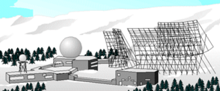
PAVE PAWS is a complex Cold War early warning radar and computer system developed in 1980 to "detect and characterize a sea-launched ballistic missile attack against the United States". The first solid-state phased array deployed used a pair of Raytheon AN/FPS-115 phased array radar sets at each site to cover an azimuth angle of 240 degrees. Two sites were deployed in 1980 at the periphery of the contiguous United States, then two more in 1987–95 as part of the United States Space Surveillance Network. One system was sold to Taiwan and is still in service.

<span class="mw-page-title-main">Ballistic Missile Early Warning System</span> US Cold War Early Warning Radar for ballistic missile defense

The RCA 474L Ballistic Missile Early Warning System was a United States Air Force Cold War early warning radar, computer, and communications system, for ballistic missile detection. The network of twelve radars, which was constructed beginning in 1958 and became operational in 1961, was built to detect a mass ballistic missile attack launched on northern approaches [for] 15 to 25 minutes' warning time also provided Project Space Track satellite data.

<span class="mw-page-title-main">Hanscom Air Force Base</span> US Air Force base near Bedford, Massachusetts, US

Hanscom Air Force Base (AFB) is a United States Air Force base located predominantly within Bedford, Massachusetts, with portions extending into the adjoining towns of Lincoln, Concord and Lexington. The facility is adjacent to Hanscom Field which provides general aviation and charter service.

<span class="mw-page-title-main">Rome Laboratory</span> US Air Force research laboratory in Rome, New York

Rome Laboratory is the US "Air Force 'superlab' for command, control, and communications" research and development and is responsible for planning and executing the USAF science and technology program.

<span class="mw-page-title-main">United States Space Surveillance Network</span> SSA system

The United States Space Surveillance Network (SSN) detects, tracks, catalogs and identifies artificial objects orbiting Earth, e.g. active/inactive satellites, spent rocket bodies, or fragmentation debris. The system is the responsibility of United States Space Command and operated by the United States Space Force.

<span class="mw-page-title-main">Over-the-horizon radar</span> Long distance radar technology

Over-the-horizon radar (OTH), sometimes called beyond the horizon radar (BTH), is a type of radar system with the ability to detect targets at very long ranges, typically hundreds to thousands of kilometres, beyond the radar horizon, which is the distance limit for ordinary radar. Several OTH radar systems were deployed starting in the 1950s and 1960s as part of early warning radar systems, but airborne early warning systems have generally replaced these. OTH radars have recently been making a comeback, as the need for accurate long-range tracking becomes less important with the ending of the Cold War, and less-expensive ground-based radars are once again being considered for roles such as maritime reconnaissance and drug enforcement.

<span class="mw-page-title-main">Jindalee Operational Radar Network</span> Over-the-horizon radar network in Australia

The Jindalee Operational Radar Network (JORN) is an over-the-horizon radar (OHR) network that can monitor air and sea movements across 37,000 square kilometres (14,000 sq mi). It has a normal operating range of 1,000 kilometres (620 mi) to 3,000 kilometres (1,900 mi). It is used in the defence of Australia, and can also monitor maritime operations, wave heights and wind directions.

<span class="mw-page-title-main">Cobra Mist</span> Anglo-American experimental over-the-horizon radar station

Cobra Mist was the codename for an Anglo-American experimental over-the-horizon radar station at Orford Ness, England. It was known technically as AN/FPS-95 and sometimes referred to as System 441a; a reference to the project as a whole.

<span class="mw-page-title-main">Mount Elkins</span> Mountain in Enderby Land, Antarctica

Mount Elkins, also known as Jökelen is a dark, steep-sided mountain with three major peaks, the highest 2,300 meters (7,500 ft) above sea level, in the Napier Mountains of Enderby Land. Enderby Land is part of East Antarctica and is claimed by Australia as part of the Australian Antarctic Territory. The mountain was named after Terence James Elkins, an ionospheric physicist with the Australian National Antarctic Research Expeditions at Mawson Station in 1960.

<span class="mw-page-title-main">Texas Tower 2</span> Former US Air Force radar station

Texas Tower 2 was a former United States Air Force Texas Tower General Surveillance Radar station, first operational in 1955. It was located 110 miles (180 km) east of Cape Cod, Massachusetts, in 56 feet (17 m). The tower was closed in 1963 and dismantled.

<span class="mw-page-title-main">Texas Tower 3</span> United States Air Force radar station

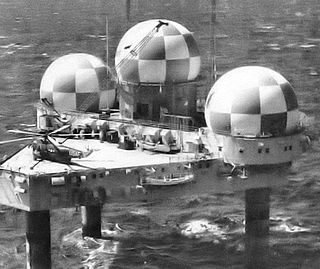
Texas Tower 3 was a former United States Air Force Texas Tower General Surveillance Radar station, first operational in November 1956. The radar station was 50 miles (80 km) southeast of the coast of Nantucket, Massachusetts, in 80 feet of water. The tower was closed in 1963 and dismantled.

The Sagamore Hill Solar Radio Observatory is a solar radio observatory located in Hamilton, Massachusetts, that operates on a daily basis to obtain scientific observations of the Sun. It is a functional component of the Radio Solar Telescope Network (RSTN).

John William Marchetti was a radar pioneer who had an outstanding career combining government and industrial activities. He was born of immigrant parents in Boston, Massachusetts, and entered Columbia College and Columbia School of Engineering and Applied Science in 1925. In a six-year program combining liberal arts and engineering, he earned both A.B. and B.S. degrees, followed by the graduate E.E. degree in 1931. He was employed by New York Edison as a power engineer for several years, during which time he also participated in the U.S. Naval Reserve as an Ensign.

<span class="mw-page-title-main">Ground Equipment Facility QRC</span> FAA radar station

Ground Equipment Facility QRC is an FAA radar station that was part of a Cold War SAGE radar station for aircraft control and warning "from Massachusetts to southern Virginia, and as far out to sea as possible." Benton AFS was also the first operational "regional data processing center" for the GE 477L Nuclear Detection and Reporting System.

Columbia Falls Air Force Station is a closed United States Air Force radar station in Washington County, Maine. Located 16.0 miles (25.7 km) northwest of Machias, Maine and 10.0 miles (16.1 km) north of Columbia Falls, it went operational in 1990 but was closed in 1997 and placed in "warm storage" with minimal maintenance. It was deactivated and placed in "cold storage" in 2002.

Moscow Air Force Station is a closed United States Air Force radar station in Somerset County, Maine. Located 6.0 miles (9.7 km) northeast of Moscow, Maine, it went operational in 1990 but was closed in 1997 and placed in "warm storage" with minimal maintenance. It was deactivated and placed in "cold storage" in 2002.

Christmas Valley Air Force Station is a closed United States Air Force radar station. It is located about 16 miles east of the community of Christmas Valley, Oregon. It was closed in 1997.

Laredo Air Force Station was a Cold War radar station of the United States Air Force in Texas.

<span class="mw-page-title-main">Eglin AFB Site C-6</span> Transmitter/receiver building in Walton County, United States

Eglin AFB Site C-6 is a United States Space Force radar station which houses the AN/FPS-85 phased array radar, associated computer processing system(s), and radar control equipment. Commencing operations in 1969, the AN/FPS-85 was the first large phased array radar. The entire radar/computer system is located at a receiver/transmitter building and is supported by the site's power plant, fire station, 2 water wells, and other infrastructure for the system. As part of the US Space Force's Space Surveillance Network its mission is to detect and track spacecraft and other manmade objects in Earth orbit for the Combined Space Operations Center satellite catalogue. With a peak radiated power of 32 megawatts the Space Force claims it is the most powerful radar in the world, and can track a basketball-sized object up to 22,000 nautical miles (41,000 km) from Earth.

Dr. Robert E. Huffman (1931–2008) was an American space scientist and author. He specialized in ultraviolet spectroscopy in the earth's upper atmosphere. Working for the United States Air Force, Dr. Huffman managed the Horizon Ultraviolet Program (HUP) experiments on two Space Shuttle flights: Columbia and Discovery.

References

  1. 1 2 McKinnon, Graeme William (1965). Gazetteer of the Australian Antarctic Territory (ANARE Interim Reports) (PDF) (Technical report). A (II) Geography. Vol. 2. Maribyrnong, Victoria, Australia: Australian Antarctic Division. p. 48. 75. Retrieved 2 December 2023.
  2. 1 2 United States Geological Survey (1989). Gazeteer of the Antarctic (PDF) (Technical report). 89-98 (4 ed.). Washington, D.C.: United States Department of the Interior, United States Geological Survey, National Mapping Division. p. 37. Retrieved 2 December 2023.
  3. 1 2 "Mount Elkins". Gazetteer of the Australian Antarctic Data Centre. Kingston, Hobart, Tasmania: Australian Antarctic Division. 2023. Retrieved 2 December 2023.
  4. 1 2 "Mount Elkins". United States Board on Geographic Names. Geographic Names Information System . Antarctica Geographic Names Database. Reston, Virginia: United States Geological Survey. 2023. Retrieved 2 December 2023.
  5. Elkins, Terence J.; Providakes, Jason (1 December 1991). HFRAD Hindcast: An OTH-B Radar and Model Comparison Study (PDF) (Technical report). NASA STI/Recon Technical Report N. Bedford, Massachusetts: The MITRE Corporation. 92. Retrieved 2 December 2023.
  6. "AN/FPS-118 Over-The-Horizon-Backscatter (OTH-B) Radar". Strategic Air Defense Systems. Alexandria, Virginia: GlobalSecurity.org. 16 June 2019. Retrieved 2 December 2023.
  7. "AN/FPS-118 Over-The-Horizon-Backscatter (OTH-B) Radar". Strategic Air Defense Systems. Washington, D.C.: Federation of American Scientists. 29 June 1999. Retrieved 2 December 2023.
  8. "Masters Awards". Astronomy Department. Boston, Massachusetts: Boston University. Archived from the original on 5 June 2011. Retrieved 2 December 2023.
  9. "Doctorate Awards". Astronomy Department. Boston, Massachusetts: Boston University. Archived from the original on 5 June 2011. Retrieved 2 December 2023.
  10. Elkins, TJ (1970). "Studies of ionospheric irregularity using radio astronomical techniques". Dissertation Abstracts International (PhD thesis). Vol. 31. Boston, Massachusetts: Boston University. p. 3130. OCLC   3592253.
  11. 1 2 "Australian Antarctic Winterers". Melbourne, Victoria, Australia: ANARE Club. 2023. Retrieved 2 December 2023.
  12. Darryn Schneider (2023). "ANARE Expeditioners 1948–1997". Antarctic History. Retrieved 2 December 2023.
  13. Barrett, Evlyn (2020). List of voyages and station parties between 1947 and 1989 in which Australians participated, including winter and some summer personnel (Report) (2 ed.). Kingston Tasmania, Australia: Australian Antarctic Data Centre. doi:10.4225/15/5ab2de9c3fe7f . Retrieved 2 December 2023.
  14. "Sydney L. Kirkby (1933 - )". History. Australian Antarctic Program. Pioneers in Antarctica. Kingston, Hobart, Tasmania: Australian Antarctic Division. 29 October 2018. Retrieved 2 December 2023. In 1960, his party undertook a remarkable 400km sledging traverse through Enderby Land from the Napier Mountains to Mawson station.
  15. Elkins, TJ (March 1980). A model for high frequency radar auroral clutter (PDF) (Technical report). RADC Technical Reports. Vol. 1980. Rome, New York: Rome Air Development Center. RADC-TR-80-122. Retrieved 2 December 2023.
  16. James M. Headrick; Stuart J. Anderson (2008). "Chapter 20: HF Over-the-Horizon Radar". In Merrill I. Skolnik (ed.). Radar Handbook (PDF) (3 ed.). New York: McGraw Hill. p. 20.40.
  17. Winkler, David F. (1997). "Radar Systems Classification Methods". Searching the Skies: The Legacy of the United States Cold War Defense Radar Program (PDF). Langley AFB, Virginia: United States Air Force Headquarters Air Combat Command. p. 73. LCCN   97020912.PD-icon.svg This article incorporates text from this source, which is in the public domain.
  18. 1 2 3 "Moscow Air Force Station". Strategic Air Defense Facilities. Alexandria, Virginia: GlobalSecurity.org. 24 July 2011. Retrieved 2 December 2023.

Further reading