Mount Elkins

Last updated • 4 min readFrom Wikipedia, The Free Encyclopedia
Mount Elkins
Mount Elkins Map.jpg
Map of Antarctica indicating the location of Mount Elkins
Highest point
Elevation 2,300 m (7,500 ft)
Coordinates 66°39′S54°08′E / 66.650°S 54.133°E / -66.650; 54.133
Geography
Location Enderby Land, East Antarctica
Parent range Napier Mountains
Geology
Age of rock 2837 million years (Archean eon)
Mountain type Metamorphic
Climbing
First ascent 1960, by a survey party from Mawson Station which included Terence James Elkins, Sydney L. Kirkby, and Neville Joseph Collins
Easiest route basic snow/ice climb

Mount Elkins, also known as Jökelen (which means "The Glacier") is a dark, steep-sided mountain with three major peaks, the highest 2,300 meters (7,500 ft) above sea level, in the Napier Mountains of Enderby Land. Enderby Land is part of East Antarctica and is claimed by Australia as part of the Australian Antarctic Territory. The mountain was named after Terence James Elkins, an ionospheric physicist with the Australian National Antarctic Research Expeditions at Mawson Station in 1960. [1] [2] [3] [4]

Contents

Location

Some notable geographic features in the general vicinity of Mount Elkins include Cape Batterbee (92 km to the north), the Young Nunataks (7.4 km to the south), Sørtoppen Nunatak (30 km to the east), the Newman Nunataks (26 km to the west), Mount McMaster (97 km to the west), and Mount Kjerringa (57 km to the northeast). The nearest permanently inhabited place is Mawson Station, an Australian research station to the southeast. Molodyozhnaya Station, a former Soviet research station that was mothballed in 1989, is located to the southwest of Mount Elkins.

Mount Elkins is the highest peak in the Napier Mountains, and also the highest peak in Enderby Land. [5]

Geology & orogeny

Much of the East Antarctic Shield was formed in the Precambrian period by a series of tectonothermal orogenic events. [6] Napier orogeny formed the cratonic nucleus approximately 4 billion years ago. [7] Mount Elkins is a classic example of Napier orogeny. Napier orogeny is characterized by high-grade metamorphism and plate tectonics. The orogenic events that resulted in the formation of the Napier Complex (including Mount Elkins) have been dated to the Archean Eon. Radiometrically dated to as old as 3.8 billion years, some of the zircons collected from the orthogneisses of the Napier Complex are among the oldest rock specimens found on Earth. [8] Billions of years of erosion and tectonic deformation have exposed the metamorphic rock core of these ancient mountains.

The oldest crustal components found to date in the Napier Complex appear to be of igneous derivation. This rock appears to have been overprinted by an ultra-high temperature metamorphic event (UHT) that occurred near the Archean-Proterozoic boundary. Using a lutetium-hafnium (Lu-Hf) method to examine garnet, orthopyroxene, sapphirine, osumilite and rutile from this UHT granulite belt, Choi et al determined an isochron age of 2.4 billion years for this metamorphic event. [8] Using SHRIMPU–Pb zircon dating methodology, Belyatsky et al determined the oldest tectonothermal event in the formation of the Napier Complex to have occurred approximately 2.8 billion years ago. [9]

Preservation of the UHT mineral assemblage in the analyzed rock suggests rapid cooling, with closure likely to have occurred for the Lu-Hf system at post-peak UHT conditions near a closure temperature of 800 °C. UHT granulites appear to have evolved in a low Lu-Hf environment, probably formed when the rocks were first extracted from a mantle profoundly depleted in lithophile elements. The source materials for the magmas that formed the Napier Complex were extremely depleted relative to the chondritic uniform reservoir (CHUR). These results also suggest significant depletion of the early Archean mantle, in agreement with the early igneous differentiation of the Earth that the latest core formation models require. [8]

Ecology

Flora

To date, no flora has been observed at Mount Elkins. [3]

Fauna

The following species have been sighted within 1.0 degrees of Mount Elkins: [3]

Scientific nameAuthorityCommon nameObservations
Balaenoptera bonaerensis Burmeister, 1867 Antarctic minke whale (also known as the dark-shoulder minke whale)
Fulmarus glacialoides Smith,1840 Southern fulmar
Halecium banzare [10] Watson, 2008Banzare hydroid
Halecium brevithecum [10] Watson, 2008Brevithecate hydroid
Pagodroma nivea Forster,1777 Snow petrel
Pygoscelis adeliae Hombron and Jacquinot,1841 Adélie penguin
Thalassoica antarctica Gmelin,1789 Antarctic petrel

Weather conditions

The Napier Mountains run northwest from Mount Elkins. To the east is a large valley formed by the Robert and Wilma Glaciers. To the northeast are the Seaton and Rippon Glaciers. All of these glaciers run into the King Edward Ice Shelf. Other notable terrain features in this area include the Beaver Glacier, located to the west of Mount King. Collectively, these terrain features significantly modify weather produced by synoptic scale systems. Dramatic changes can occur over short distances and in short time intervals. [11] [12]

Nearby terrain features

Place names within 1.0 degrees of Mount Elkins (Latitude 66°40.0'S Longitude 54°09.0'E)

NameFeatureLatitudeLongitudeDistanceBearing
Aagaard Islands Island 65°51.0'S53°40.0'E93.4 km346°
Armstrong Peak Peak 66°24.0'S53°23.0'E45.1 km311°
Bandy Nunataks Nunatak 66°55.0'S53°36.0'E36.8 km221°
Bird Ridge Ridge 66°47.0'S55°04.0'E42.3 km108°
Bratthø Peak 66°39.0'S54°40.0'E22.8 km086°
Cape Batterbee Cape 65°51.0'S53°48.0'E92.2 km350°
Conradi Peak Peak 66°08.0'S54°35.0'E62.4 km018°
Doyle Point Point 65°53.0'S54°52.0'E92.8 km021°
Grimsley Peaks Peak 66°34.0'S53°40.0'E24.1 km297°
Knausen Peak 66°22.0'S53°13.0'E53.1 km308°
Mjåkollen Peak 66°33.0'S53°28.0'E32.8 km293°
Mount Bennett Mountain 66°32.0'S53°38.0'E27.2 km303°
Mount Breckinridge Mountain 66°37.0'S53°41.0'E21.3 km285°
Mount Bride Mountain 66°26.0'S53°57.0'E27.4 km341°
Mount Gate Mountain 66°51.0'S53°18.0'E42.5 km241°
Mount Griffiths Mountain 66°28.0'S54°01.0'E23.0 km345°
Mount Maines Mountain 66°38.0'S53°54.0'E11.6 km288°
Mount Pasco Mountain 66°59.0'S54°44.0'E43.5 km144°
Mount Stadler Mountain 66°54.0'S53°14.0'E47.8 km237°
Napier Mountains Mountain 66°30.0'S53°40.0'E28.3 km311°
Newman Nunataks Nunatak 66°40.0'S54°45.0'E26.4 km090°
Proclamation Island Island 65°51.0'S53°41.0'E93.2 km347°
Rabben Peak 66°27.0'S54°07.0'E24.1 km356°
Skarvet Nunatak Nunatak 66°26.0'S53°45.0'E31.4 km326°
Sørtoppen Nunatak Nunatak 66°40.0'S53°28.0'E30.1 km270°
Tippet Nunataks Nunatak 66°44.0'S53°15.0'E40.3 km259°
Vicars Island Island 65°50.0'S54°29.0'E93.9 km009°
Wheeler Rocks Rock 66°17.0'S55°08.0'E61.0 km046°
Wilkinson Peaks Peak 66°37.0'S54°15.0'E7.1 km038°
Young Nunataks Nunatak 66°44.0'S54°08.0'E7.4 km186°

History

Mount Elkins was first mapped by Norwegian cartographers from aerial photographs taken by the Lars Christensen Expedition, 1936–37, and named at that time Jökelen (The Glacier). It was remapped by ANARE from aerial photographs taken from an ANARE aircraft in 1956. The Napier Mountains were first visited by an ANARE survey party from Mawson Station in 1960. The survey party was led by Syd Kirkby and included Terence James Elkins.

Significance to mountaineers

The summit of Mount Elkins is higher than that of any mountain in Australia—including even Mount Kosciuszko (2,228 metres), which is one of the Seven Summits. Because of its remoteness it has not become a popular target for peak bagging.

See also

Related Research Articles

<span class="mw-page-title-main">Mawson Station</span> Antarctic station in Australian Antarctic Territory

Mawson Station, commonly called Mawson, is one of three permanent bases and research outposts in Antarctica managed by the Australian Antarctic Division (AAD). Mawson lies in Holme Bay in Mac. Robertson Land, East Antarctica in the Australian Antarctic Territory, a territory claimed by Australia. Established in 1954, Mawson is Australia's oldest Antarctic station and the oldest continuously inhabited Antarctic station south of the Antarctic Circle. It houses approximately 20 personnel over winter and up to 53 in summer.

<span class="mw-page-title-main">Lambert Glacier</span> Major glacier in East Antarctica

Lambert Glacier is a major glacier in East Antarctica. At about 80 km (50 mi) wide, over 400 km (250 mi) long, and about 2,500 m (8,200 ft) deep, it is the world's largest glacier. It drains 8% of the Antarctic ice sheet to the east and south of the Prince Charles Mountains and flows northward to the Amery Ice Shelf. It flows in part of Lambert Graben and exits the continent at Prydz Bay.

Cape Ann is a cape on the coast of East Antarctica, surmounted by Mount Biscoe rising to a peak of 700 metres.

Mount Codrington is a prominent mountain, 1,520 metres (5,000 ft) high, standing 24 miles (39 km) south-southeast of Cape Close, 17 miles (27 km) east of Johnston Peak, and 11 miles (18 km) south of Simmers Peaks. Mount Codrington forms the northeastern end of the Napier Mountains.

The Tula Mountains are a group of extensive mountains lying immediately eastward of Amundsen Bay in Enderby Land, Antarctica. They were discovered on January 14, 1930, by the British Australian New Zealand Antarctic Research Expedition (BANZARE) under Mawson and named "Tula Range" by him after John Biscoe's brig, the Tula, from which Biscoe discovered Enderby Land in 1831. The term "mountains" was recommended for the group following an ANARE sledge survey in 1958 by G.A. Knuckey.

The Napier Mountains are a group of close set peaks, the highest being Mount Elkins, at about 2,300 meters above sea level. This mountain range is located in Enderby Land, in the claimed Australian Antarctic Territory, East Antarctica.

The Scott Mountains are a large number of isolated peaks lying south of Amundsen Bay in Enderby Land of East Antarctica, Antarctica. Discovered on 13 January 1930 by the British Australian New Zealand Antarctic Research Expedition (BANZARE) under Sir Douglas Mawson. He named the feature Scott Range after Captain Robert Falcon Scott, Royal Navy. The term mountains is considered more appropriate because of the isolation of its individual features.

<span class="mw-page-title-main">Enderby Land</span> Projecting landmass of Antarctica

Enderby Land is a projecting landmass of Antarctica. Its shore extends from Shinnan Glacier at about 67°55′S44°38′E to William Scoresby Bay at 67°24′S59°34′E, approximately 124 of the earth's longitude. It was first documented in western and eastern literature in February 1831 by John Biscoe aboard the whaling brig Tula, and named after the Enderby Brothers of London, the ship's owners who encouraged their captains to combine exploration with sealing.

<span class="mw-page-title-main">Mount Biscoe</span> Mountain in Enderby Land, Antarctica

Mount Biscoe is a distinctive black peak, the easternmost and largest of two ice-free rock massifs located 6 km south-west of Cape Ann on the coast of Enderby Land in Antarctica. About 700 m in height, it lies 7 km north-west of Wordie Nunatak, and 7 km north-east of Mount Hurley.

<span class="mw-page-title-main">Geology of Antarctica</span> Geologic composition of Antarctica

The geology of Antarctica covers the geological development of the continent through the Archean, Proterozoic and Phanerozoic eons.

<span class="mw-page-title-main">Mount Kjerringa</span> Mountain in Enderby Land, Antarctica

Mount Kjerringa is an isolated peak, 1,220 metres (4,000 ft) above sea level, situated roughly 8 nmi (15 km) north of the Aker Peaks, 26 nmi (48 km) west of Magnet Bay, and 57 km (31 nmi) northeast of Mount Elkins in Enderby Land, East Antarctica.

Newman Nunataks

<span class="mw-page-title-main">Terence James Elkins</span>

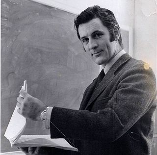
Terence James Elkins is an Australian-born American physicist. In 1960, he participated in an expedition from Mawson Station which conducted the first geological surveys of the Napier Mountains in Enderby Land, East Antarctica. The highest of this group of mountains, Mount Elkins, was subsequently named after him. In 1979, he received the Harold Brown Award, the United States Air Force's highest honor for research and development, for research he conducted that contributed to the development of the AN/FPS-115, AN/FPS-117 and AN/FPS-118 over-the-horizon backscatter (OTH-B) air defense radar system. Designed to replace the aging Ballistic Missile Early Warning System system, these systems are among the most powerful early-warning radar systems ever developed.

Sydney Lorrimar Kirkby, is an Australian surveyor and Antarctic explorer.

<span class="mw-page-title-main">Mount Maines</span>

Mount Maines, also known as Stornuten, is a mountain, 2,190 metres (7,190 ft), standing roughly 13 kilometres (8.1 mi) SE of Stor Hånakken Mountain and 10 kilometres (6.2 mi) W of Mount Elkins in the Napier Mountains, Enderby Land.

Rippon Glacier is a small glacier located in Kemp Land, East Antarctica. It is close east of Seaton Glacier, flowing southward into Edward VIII Ice Shelf.

Mount King is a large, smooth-crested mountain in the eastern extremity of the Tula Mountains. Part of the Australian Antarctic Gazetteer and the SCAR Composite Gazetteer of Antarctica, it is located in Enderby Land, East Antarctica, which is claimed by Australia as part of the Australian Antarctic Territory. The head of Beaver Glacier is located very close to the base of Mount King.

<span class="mw-page-title-main">Armstrong Peak</span> Mountain in Antarctica

Armstrong Peak is a peak, 1,470 metres (4,820 ft) high, standing 15 nautical miles (28 km) southeast of Mount Codrington in Enderby Land of East Antarctica.

<span class="mw-page-title-main">Wilkinson Peaks</span>

The Wilkinson Peaks, also known as Langnabbane, is a group of peaks in the Napier Mountains standing 8 kilometres (5.0 mi) southeast of Mount Griffiths and 8 kilometres (5.0 mi) northeast of Mount Elkins in Enderby Land.

Mount Weller is a mountain, 1,080 m, standing west of Auster Glacier and 2 nautical miles (3.7 km) east of Reference Peak in Enderby Land. It was plotted from air photos taken by ANARE in 1956 and was named by the Antarctic Names Committee of Australia (ANCA) for G.E. Weller, a meteorologist at Mawson Station in 1961.

References

  1. McKinnon, Graeme William (1965). Gazetteer of the Australian Antarctic Territory (ANARE Interim Reports) (PDF) (Technical report). A (II) Geography. Vol. 2. Maribyrnong, Victoria, Australia: Australian Antarctic Division. p. 48. 75. Retrieved 2 December 2023.
  2. United States Geological Survey (1989). Gazeteer of the Antarctic (PDF) (Technical report). 89-98 (4 ed.). Washington, D.C.: United States Department of the Interior, United States Geological Survey, National Mapping Division. p. 37. Retrieved 2 December 2023.
  3. 1 2 3 "Mount Elkins". Gazetteer of the Australian Antarctic Data Centre. Kingston, Hobart, Tasmania: Australian Antarctic Division. 2023. Retrieved 2 December 2023.
  4. "Mount Elkins". United States Board on Geographic Names. Geographic Names Information System . Antarctica Geographic Names Database. Reston, Virginia: United States Geological Survey. 2023. Retrieved 2 December 2023.
  5. Slayden G (2004). "Major Peaks of the Enderby Land Coast". Peakbagger.com. Retrieved 2010-11-26.
  6. Lloyd G, Gibson M. "Geochronology of the Transantarctic Mountains". Tectonics of the Transantarctic Mountains. London: self-published. Archived from the original on May 4, 2003. Retrieved 2010-11-26.
  7. Lloyd G, Gibson M. "Crustal Formation sequence". Tectonics of the Transantarctic Mountains. London: self-published. Archived from the original on May 13, 2003. Retrieved 2010-11-26.
  8. 1 2 3 Choi SH, Mukasa SB, Andronikov AV, Osanai Y, Harley SL, Kelly NM (2006). "Lu Hf systematics of the ultra-high temperature Napier Metamorphic Complex in Antarctica: Evidence for the early Archean differentiation of Earth's mantle". Earth and Planetary Science Letters. 246 (3–4): 305–316. doi:10.1016/j.epsl.2006.04.012.
  9. Belyatsky, BV; Rodionov, NV; Sergeev, SA; Kamenev, EN (2007). Cooper, AK; Raymond, CR (eds.). New evidence for the early Archaean evolution of Aker Peaks, Napier Mountains, Enderby Land (East Antarctica) (PDF). Vol. Antarctica: A Keystone in a Changing World—Online Proceedings for the 10th International Symposium on Antarctic Earth Sciences. Santa Barbara, California: U.S. Geological Survey. pp. 187.1–187.4. ISBN   978-0-309-11854-5.
  10. 1 2 Watson, Jeanette E. (2008). "Hydroids of the BANZARE expeditions, 1929–1931: the family Haleciidae (Hydrozoa, Leptothecata) from the Australian Antarctic Territory" (PDF). Memoirs of Museum Victoria. 65 (9): 165–178. doi:10.24199/j.mmv.2008.65.9.
  11. Pendlebury, Stephen (2004). "Section 7.6: Enderby Land and Kemp Land". In Turner, John; Pendlebury, Stephen (eds.). The International Antarctic Weather Forecasting Handbook (PDF) (1st ed.). Cambridge, England: British Antarctic Survey. pp. 362–365. ISBN   1-85531-221-2.
  12. "Current Weather Conditions near Mount Elkins". Napier Mountains Forecasts. Mountain-Forecast.com. 2023. Retrieved 2 December 2023.

Further reading

PD-icon.svg This article incorporates public domain material from "Mount Elkins". Geographic Names Information System . United States Geological Survey.