Thiébauménil

Last updated • 2 min readFrom Wikipedia, The Free Encyclopedia

Thiébauménil
Thiebaumenil (M-et-M) mairie.jpg
The town hall in Thiébauménil
Blason Thiebaumenil 54.svg
Location of Thiébauménil
Thiebaumenil
France location map-Regions and departements-2016.svg
Red pog.svg
Thiébauménil
Grand Est region location map.svg
Red pog.svg
Thiébauménil
Coordinates: 48°34′50″N6°37′24″E / 48.5806°N 6.6233°E / 48.5806; 6.6233
Country France
Region Grand Est
Department Meurthe-et-Moselle
Arrondissement Lunéville
Canton Baccarat
Intercommunality CC Territoire de Lunéville à Baccarat
Government
  Mayor (20202026) Dominique Robert [1]
Area
1
3.87 km2 (1.49 sq mi)
Population
 (2021) [2]
382
  Density99/km2 (260/sq mi)
Time zone UTC+01:00 (CET)
  Summer (DST) UTC+02:00 (CEST)
INSEE/Postal code
54520 /54300
Elevation232–293 m (761–961 ft)
(avg. 240 m or 790 ft)
1 French Land Register data, which excludes lakes, ponds, glaciers > 1 km2 (0.386 sq mi or 247 acres) and river estuaries.

Thiébauménil (French pronunciation: [tjebomenil] ) is a commune in the Meurthe-et-Moselle department in Grand Est, France.

Contents

Geography

Thiébauménil is located on the Vezouze at 3,500m. To the west stretches a vast plateau with siliceous soil, to the east rises a hillside with clay soil towards Manonviller where a fort was established.

The town is 10 km from Lunéville.

Town Planning

Typology

Thiébauménil is a rural municipality, because it is one of the low or very low density municipalities, within the meaning of the INSEE municipal density grid.

In addition, the commune is part of the Nancy attraction area, of which it is a commune of the crown. [3] This area, which includes 353 municipalities, is categorized in areas with 200,000 to less than 700,000 inhabitants. [4] [5]

Land use

The land cover of the municipality, as it appears from the European biophysical land cover database Corine Land Cover (CLC), is marked by the importance of agricultural land (66.9% in 2018), a proportion roughly equivalent to that of 1990 (66.4%). The detailed distribution in 2018 is as follows: arable land (37.5%), forests (23.9%), grasslands (19.4%), heterogeneous agricultural areas (10%), urbanized areas (9%), areas industrial or commercial and communication networks (0.2%).

The IGN also provides an online tool to compare the evolution over time of land use in the municipality (or territories at different scales). Several periods are accessible in the form of maps or aerial photos: the Cassini map (18th century), the staff map (1820-1866) and the current period (1950 to today). [6]

Toponymy

From a personal name Theotbald (Thibaut) + mansionile.

Tibamesni (1152), Theobalmasnil (1156), Thiebautmanil (1268).

History

The villages of Thiébauménil and Marainviller have intimately intertwined histories. Their territories have been part of the many possessions of the Abbey of Belchamp since the 12th century.

Devastated during the Thirty Years War, Thiébauménil suffered a fire on 26 September 1632 which destroyed 42 homes. After the wars, in 1712, the parish had only 25 households. There were 135 in 1888. Thiébauménil was again annexed on 3 July 1811 to Marainviller.

On 13 August 1911 a station on the line from Lunéville to Blâmont and Badonviller (the LBB) was inaugurated in Thiébauménil by Minister Albert Lebrun. The line's traffic operated until 1942. The station, located south of the town, became a dwelling in the 21st century.

Demographics

Historical population
YearPop.±% p.a.
1968 271    
1975 237−1.90%
1982 329+4.80%
1990 332+0.11%
1999 360+0.90%
2009 395+0.93%
2014 388−0.36%
2020 382−0.26%
Source: INSEE [7]

In 2020, the town had 382 inhabitants, down 1.55% compared to 2014 (Meurthe-et-Moselle: +0.06%, France excluding Mayotte: +1.9%).

Economy

Basketry was a traditional activity of the town.

As of 24 August 2021 Thiébauménil has 27 establishments: 13 in the operation of real estate, 7 in animal production, 3 in non-store trade, 2 in administration and 2 for human health. [8]

See also

Related Research Articles

<span class="mw-page-title-main">Drancy</span> Commune in Île-de-France, France

Drancy is a commune in the northeastern suburbs of Paris in the Seine-Saint-Denis department in northern France. It is located 10.8 km (6.7 mi) from the center of Paris.

<span class="mw-page-title-main">Pantin</span> Commune in Île-de-France, France

Pantin is a commune in the northeastern suburbs of Paris, Île-de-France, France. It is located 6.4 km (4.0 mi) from the centre of Paris. In 2019 its population was estimated to be 59,846. Pantin is located on the edge of the city of Paris and is mainly formed by a plain crossed by national roadway 2 and 3, the Paris–Strasbourg railway line and the canal de l'Ourcq.

<span class="mw-page-title-main">Bobigny</span> Prefecture and commune in Île-de-France, France

Bobigny is a commune, or town, in the northeastern suburbs of Paris, Île-de-France, France. It is located 9.1 km (5.7 mi) from the centre of Paris. Bobigny is the prefecture of the Seine-Saint-Denis department, as well as the seat of the Arrondissement of Bobigny. It is the 11th most populous commune in Seine-Saint-Denis (2019).

<span class="mw-page-title-main">Le Bourget</span> Commune in Île-de-France, France

Le Bourget is a commune in the northeastern suburbs of Paris, France. It is located 10.6 km from the center of Paris.

<span class="mw-page-title-main">La Courneuve</span> Commune in Île-de-France, France

La Courneuve is a commune in Seine-Saint-Denis, France. It is located 8.3 km (5.2 mi) from the center of Paris.

<span class="mw-page-title-main">Le Kremlin-Bicêtre</span> Commune in Île-de-France, France

Le Kremlin-Bicêtre is a commune in the southern suburbs of Paris, France. It is 4.5 km (2.8 mi) from the center of Paris. It is one of the most densely populated municipalities in Europe.

<span class="mw-page-title-main">Saint-Martin-de-Bavel</span> Commune in Auvergne-Rhône-Alpes, France

Saint-Martin-de-Bavel is a commune in the Ain department in eastern France.

<span class="mw-page-title-main">Solbach</span> Commune in Grand Est, France

Solbach is a commune in the Bas-Rhin department in Grand Est in north-eastern France.

<span class="mw-page-title-main">Chambon, Cher</span> Commune in Centre-Val de Loire, France

Chambon is a commune in the Cher department in the Centre-Val de Loire region of France.

<span class="mw-page-title-main">Marcilly-sur-Tille</span> Commune in Bourgogne-Franche-Comté, France

Marcilly-sur-Tille is a commune in the Côte-d'Or department in eastern France.

<span class="mw-page-title-main">Maxilly-sur-Saône</span> Commune in Bourgogne-Franche-Comté, France

Maxilly-sur-Saône is a commune in the Côte-d'Or department in the Bourgogne-Franche-Comté region in eastern France. The inhabitants are called Maximilliens and Maximilliennes.

<span class="mw-page-title-main">Étrabonne</span> Commune in Bourgogne-Franche-Comté, France

Étrabonne is a commune in the Doubs department in the Bourgogne-Franche-Comté region in eastern France.

<span class="mw-page-title-main">Chicourt</span> Commune in Grand Est, France

Chicourt is a commune in the Moselle department in Grand Est in north-eastern France.

<span class="mw-page-title-main">Bergholtz, Haut-Rhin</span> Commune in Grand Est, France

Bergholtz is a commune in the Haut-Rhin department in Grand Est in north-eastern France, and, since 1 January 2021, the European collectivity of Alsace. The commune is in the historic and cultural region of Alsace.

Talasani is a rural commune and village on the eastern seaboard of Corsica, in the Haute-Corse department of France. The area has a very low population density and mainly comprises forests and farmland. As a coastal municipality, Talasani enforces strict urban planning provisions in order to preserve the ecological balance of the coast.

<span class="mw-page-title-main">Vaux-le-Moncelot</span> Commune in Bourgogne-Franche-Comté, France

Vaux-le-Moncelot is a commune in the Haute-Saône department in the region of Bourgogne-Franche-Comté in eastern France.

<span class="mw-page-title-main">Moncel-lès-Lunéville</span> Commune in Grand Est, France

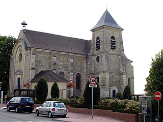
Moncel-lès-Lunéville is a commune in the Meurthe-et-Moselle department in north-eastern France.

<span class="mw-page-title-main">Breistroff-la-Grande</span> Commune in Grand Est, France

Breistroff-la-Grande is a commune in the Moselle department in Grand Est in northeastern France.

<span class="mw-page-title-main">Bonneuil-en-France</span> Commune in Île-de-France, France

Bonneuil-en-France is a commune in the Val-d'Oise department in Île-de-France in northern France.

<span class="mw-page-title-main">Canton of Lunéville-Sud</span> Former canton in Meurthe-et-Moselle, France

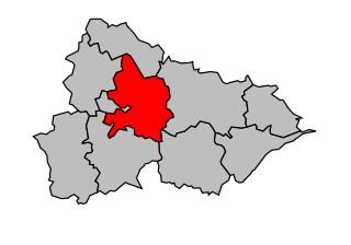
The canton of Lunéville-Sud is a former French canton located in the department of Meurthe-et-Moselle in the Lorraine region. This canton was organized around Lunéville in the arrondissement of Lunéville. It is now part of the canton of Lunéville-2.

References

  1. "Répertoire national des élus: les maires". data.gouv.fr, Plateforme ouverte des données publiques françaises (in French). 9 August 2021.
  2. "Populations légales 2021" (in French). The National Institute of Statistics and Economic Studies. 28 December 2023.
  3. In October 2020, the notion of city attraction area replaced the old notion of urban area, to allow consistent comparisons with other countries of the European Union
  4. https://www.insee.fr/fr/information/4803954 "Base des aires d'attraction des villes 2020". insee.fr. 21 October 2020. Retrieved 30 March 2021. .
  5. Marie-Pierre de Bellefon, Pascal Eusebio, Jocelyn Forest, Olivier Pégaz-Blanc and Raymond Warnod (Insee), https://www.insee.fr/fr/statistiques/4806694 Marie-Pierre de Bellefon, Pascal Eusebio, Jocelyn Forest, Olivier Pégaz-Blanc et Raymond Warnod (Insee) (21 October 2020). "En France, neuf personnes sur dix vivent dans l'aire d'attraction d'une ville". insee.fr. Retrieved 30 March 2021.{{cite web}}: CS1 maint: multiple names: authors list (link) .
  6. "Remonter le temps". remonterletemps.ign.fr. Retrieved 27 February 2023. To compare the evolution between two dates, click on the bottom of the vertical dividing line and move it to the right or to the left. To compare two other cards, choose the cards in the windows at the top left of the screen.
  7. Population en historique depuis 1968, INSEE
  8. Companies in Thiébauménil, to read on https://entreprises.lefigaro.fr/thiebaumenil/ville-54520