Hunts Point is a town in the Eastside, a region of King County, Washington, United States, and part of the Seattle metropolitan area. The town is on a small peninsula surrounded by Lake Washington, and is near the suburbs of Medina, Clyde Hill, Yarrow Point, and Kirkland, as well as the city of Bellevue. As of the 2010 census, the town had a total population of 394.

Manchester is an unincorporated community and census-designated place (CDP) in Kitsap County, Washington, United States. The population was 5,714 at the 2020 census. Manchester is located on the Puget Sound approximately 10 miles from downtown Seattle, and is adjacent to county seat Port Orchard to its east. Today, Manchester labels itself as a village. It is small in size but is home to a Kitsap Regional Library (KRL) branch, a post office, an elementary school, and a beachfront park to serve its residents.
Poulsbo is a city on Liberty Bay in Kitsap County, Washington, United States. It is the smallest of the four cities in Kitsap County. The population was 9,200 at the 2010 census and an estimated 10,927 in 2018.

Orting is a city in Pierce County, Washington, United States. The population was 9,041 at the 2020 census.

Vigor Shipyards is the current entity operating the former Todd Shipyards after its acquisition in 2011. Todd Shipyards was founded in 1916, which owned and operated shipyards on the West Coast of the United States, East Coast of the United States and the Gulf. Todd Shipyards were a major part of the Emergency Shipbuilding Program for World War II.

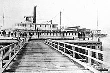
Harbor Island is an artificial island in the mouth of the Duwamish River in Seattle, Washington, US, where it empties into Elliott Bay. Built by the Puget Sound Bridge and Dredging Company, it was completed in 1909 and was then the largest artificial island in the world, at 350 acres (1.4 km2). Since 1912, the island has been used for commercial and industrial activities including secondary lead smelting, shipbuilding and repair, bulk petroleum storage, metal fabrication and containerized cargo shipping. Warehouses, laboratories and other buildings are located on the island.
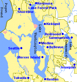
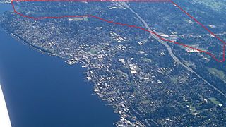
The Eastside of the King County, Washington area in the United States is a collective term for the suburbs of Seattle located on the east side of Lake Washington.

Mukilteo Lighthouse Park encompasses the lighthouse at the west end of the city of Mukilteo, Washington, and 12 acres (0.049 km2) south of it. The property is west and south of the Washington State Ferries terminal with ferry service to Clinton, Whidbey Island, and is bordered on the south and east by the BNSF Railway mainline. Whidbey Island lies across a narrow portion of Possession Sound and is easily visible from the shore.
Pilchuck Glass School is an international center for glass art education. The school was founded in 1971 by Dale Chihuly, Anne Gould Hauberg (1917-2016), and John H Hauberg (1916-2002). The campus is located on a former tree farm in Stanwood, Washington in the United States, and the administrative offices are located in Seattle, Washington. The name "Pilchuck" comes from the local Native American language and translates to "red water" in reference to the Pilchuck River. Pilchuck offers one, two, or three week resident classes each summer in a broad spectrum of glass techniques as well as residencies for emerging and established artists working in all media.

Port Blakely is a community of Bainbridge Island, Washington in the western United States. It is located on the east side of the island, slightly to the south. The center of Port Blakely is generally defined as the intersection of Blakely Hill Road and Blakely Avenue NE, although the wider area is generally also known as Port Blakely.
Clearview is a small unincorporated community and census-designated place (CDP) in Snohomish County, Washington, United States. The population was 3,324 at the 2010 census. Clearview is located on both sides of State Route 9, where it intersects 180th Street SE in Snohomish County, Washington, United States. It is located between Snohomish and Woodinville and the top of the Clearview Hill.
Browns Point is a census-designated place (CDP) in Pierce County, Washington, United States, bordered by Tacoma on the east and Puget Sound on all other sides. The population was 1,198 at the 2010 census. The Tacoma neighborhood immediately adjacent to Browns Point is also referred to locally as "Browns Point".

Quartermaster Harbor is a small harbor located in southern Puget Sound, in Vashon Island, Washington state.
Orting High School is a high school located in Orting, Washington that serves students from grades 9–12 in the Orting and surrounding areas. The mascot is the Cardinal, and the Orting Cardinals was a member of the Nisqually League. OHS is now part of the SPSL 2A league.
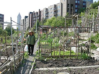
The Danny Woo International District Community Garden is a community garden on the outskirts of the International District, Seattle, Washington. It was built in 1975 and provides 101 allotments and 77 fruit trees.

Squaxin Park is a public park located in Olympia, Washington. Established in 1905, it was the city's first waterfront park, providing access to the Budd Inlet of Puget Sound. The park was formerly known as Priest Point Park, but was renamed in 2022 after the Olympia City Council unanimously voted to change it to honor the local Squaxin island Tribe.

Monsignor Francis Xavier Prefontaine (1838–1909) was a French Canadian priest and missionary, an early resident in the pioneer days of Seattle, Washington, and a figure in the history of Seattle and the Puget Sound region of Washington State. He was Seattle's first resident Roman Catholic priest and built Seattle's first Catholic church.
Forbes Creek is a small, moderately sloping creek wholly within the city of Kirkland, Washington. From its headwaters on the Rose Hill moraine to its outlet at Juanita Bay is c. 2 miles (3.2 km) as the crow flies. The northern extent of its basin is a nearly east–west line at NE 116th Street; the eastern boundary is at the Rose Hill ridgeline, roughly north–south at 132nd Avenue NE. The southern extent is irregular trending roughly from Kirkland's high point at the northeast corner of Bridle Trails State Park through South Rose Hill Park, to Lake Washington at 16 feet (4.9 m) above sea level.

The Liberal Arts Quadrangle, more popularly known as the Quad, is the main quadrangle at the University of Washington in Seattle, Washington. It is often considered the school's trademark attraction. Raitt Hall and Savery Hall frame the northwestern boundary while Gowen, Smith, and Miller Halls frame the southeast. At the top of the quad sits the latest buildings on the quad, the Art and Music Buildings. The quad is lined with thirty Yoshino cherry trees, which blossom between mid-March and early April.
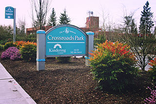
Crossroads is a neighborhood in Bellevue, Washington. It is situated in the north and eastern portion of the city, lying south of Bellevue-Redmond Road, east of Bellevue's Wilburton neighborhood, and north of Lake Hills.