
Cape Cod is a geographic cape extending into the Atlantic Ocean from the southeastern corner of mainland Massachusetts, in the northeastern United States. Its historic, maritime character and ample beaches attract heavy tourism during the summer months.

The Cape Cod National Seashore (CCNS), created on August 7, 1961 by President John F. Kennedy, encompasses 43,607 acres on Cape Cod, in Massachusetts. It includes ponds, woods and beachfront of the Atlantic coastal pine barrens ecoregion. The CCNS includes nearly 40 miles (64 km) of seashore along the Atlantic-facing eastern shore of Cape Cod, in the towns of Provincetown, Truro, Wellfleet, Eastham, Orleans and Chatham. It is administered by the National Park Service.

Wellfleet is a town in Barnstable County, Massachusetts, United States, and is located halfway between the "tip" and "elbow" of Cape Cod. The town had a population of 2,750 at the 2010 census, which swells nearly sixfold during the summer. A total of 70% of the town's land area is under protection, and nearly half of it is part of the Cape Cod National Seashore. Wellfleet is famous for its oysters, which are celebrated in the annual October Wellfleet OysterFest.

Barnstable County is a county located in the U.S. state of Massachusetts. As of the 2010 census, the population was 215,888. Its county seat is Barnstable. The county consists of Cape Cod and associated islands.
Eastham is a town in Barnstable County, Massachusetts, United States, Barnstable County being coextensive with Cape Cod. The population was 4,956 at the 2010 census.

North Eastham is a census-designated place (CDP) in the town of Eastham in Barnstable County, Massachusetts, United States. The population was 1,806 at the 2010 census.

Brewster is a town in Barnstable County, Massachusetts, United States, Barnstable County being coextensive with Cape Cod. The population of Brewster was 9,820 at the 2010 census.

Orleans is a town in Barnstable County, Massachusetts situated along Cape Cod. The population was 5,890 at the 2010 census.
Thumper or The Thumper may refer to:
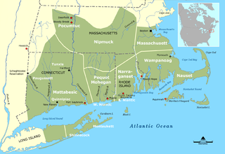
The Nauset people, sometimes referred to as the Cape Cod Indians, lived in what is present-day Cape Cod, Massachusetts, living east of Bass River and lands occupied by their closely related neighbors, the Wampanoag. Although a distinct tribe, they were often subject to Wampanoag overlordship and shared many similar aspects of culture, agricultural practices, and a common tongue, the Massachusett language. Due to their ocean proximity, they had a greater reliance on seafood than other tribes. The tribe was one of the first to be visited by European seafarers, whose abduction of tribal members for slavery and introduction of diseases reduced the Nauset population even before large-scale colonization of New England. The pilgrims' first contact with the Nauset was during their landing near present-day Provincetown, when they discovered a deserted village, the Nauset being away at their winter hunting grounds. Desperately low on supplies, the pilgrims helped themselves to a cache of maize, though they left a note promising to pay for what they had stolen. The promise was eventually kept when the Nauset returned months later. The Nauset also returned a small boy who had wandered away from the colony and become lost, an act which greatly improved relations with the colonists.

Prunus maritima, the beach plum, is a species of plum native to the East Coast of the United States, from Maine south to Maryland. Although sometimes listed as extending to New Brunswick, the species is not known from collections there, and does not appear in the most authoritative works on the flora of that Canadian province.

The Eastham Windmill, located in Eastham, Massachusetts, is the oldest windmill on Cape Cod. It was constructed by Eastham resident Thomas Paine in Plymouth in 1680. It was first moved to nearby Truro in 1770, then finally to Eastham in 1793. In 1808 the windmill was moved to its present location, near the Eastham Town Hall and the Eastham Public Library. Eastham Windmill, as part of the Eastham Center Historic District, was added to the National Register of Historic Places in 1999.

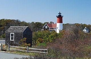
Nauset Light, officially Nauset Beach Light, is a restored lighthouse on the Cape Cod National Seashore near Eastham, Massachusetts, erected in 1923 using the 1877 tower that was moved here from the Chatham Light. It is listed on the National Register of Historic Places. The tower is a cast iron plate shell lined with brick and stands 48 feet (15 m) high. The adjacent oil house is made of brick and has also been restored. Fully automated, the beacon is a private aid to navigation. Tours of the tower and oil house are available in summer from the Nauset Light Preservation Society which operates, maintains and interprets the site.

The Cape Cod Rail Trail (CCRT) is a 25.5-mile (41.0 km) paved rail trail located on Cape Cod in Massachusetts. The trail route passes through the towns of Yarmouth, Dennis, Harwich, Brewster, Orleans, Eastham, and Wellfleet. It connects to the 6-plus mile (10 km) Old Colony Rail Trail leading to Chatham, the 2 mile Yarmouth multi-use trail, and 8 miles (13 km) of trails within Nickerson State Park. Short side trips on roads lead to national seashore beaches including Coast Guard Beach at the end of the Nauset Bike Trail in Cape Cod National Seashore. The entire trail is part of the Claire Saltonstall Bike Route.

Massachusetts's sixteenth congressional district is an obsolete district. It was also for a short time in the early 19th century a Massachusetts District of Maine. It was eliminated in 1933 after the 1930 Census. Its last location was in eastern Massachusetts at Cape Cod. Its last Congressman was Charles L. Gifford, who was redistricted into the fifteenth district.

The Nauset Archaeological District is a National Historic Landmark District in Eastham, Massachusetts. Located within the southern portion of the Cape Cod National Seashore, this area was the location of substantial ancient settlements since at least 4,000 BC.
The French Cable Hut is a historic building in Cape Cod National Seashore, near the Nauset Beach Light in Eastham, Massachusetts. Built in 1891, the hut formed a linkage point in the transatlantic telegraph cable of the French Cable Company connecting the cable, where it came ashore near the present site to its main station in Orleans. After the cable was abandoned in 1932, the hut was adapted for residential use. It has since been restored to its turn-of-the-century appearance by the National Park Service. The building was listed on the National Register of Historic Places in 1976.
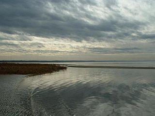
Cooks Brook Beach is a Town of Eastham beach on the bay side of Cape Cod, in North Eastham, Massachusetts. It is located at the end of Steele Road, which is off Massasoit Road.

