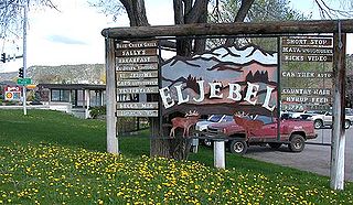
El Jebel is an unincorporated community and a census-designated place (CDP) located in and governed by Eagle County, Colorado, United States. The CDP is a part of the Edwards, CO Micropolitan Statistical Area. The population of the El Jebel CDP was 4,130 at the United States Census 2020. The Carbondale Post Office serves El Jebel postal addresses.
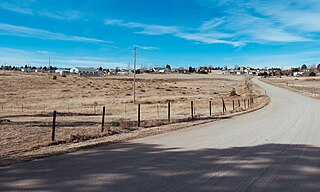
Ponderosa Park is an unincorporated community and a census-designated place (CDP) located in and governed by Elbert County, Colorado, United States. The CDP is a part of the Denver–Aurora–Lakewood, CO Metropolitan Statistical Area. The population of the Ponderosa Park CDP was 3,334 at the United States Census 2020. Elbert County governs the unincorporated community. The Elizabeth post office serves the area.

Silt is a Statutory Town in Garfield County, Colorado, United States. The population was 3,536 at the 2020 census, up from 2,930 at the 2010 census.
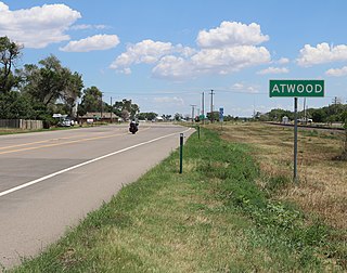
Atwood is an unincorporated town, a post office, and a census-designated place (CDP) located in and governed by Logan County, Colorado, United States. The CDP is a part of the Sterling, CO Micropolitan Statistical Area. The Atwood post office has the ZIP Code 80722. At the United States Census 2020, the population of the Atwood CDP was 138.

Otis is a Statutory Town in Washington County, Colorado, United States. The population was 511 at the 2020 census.
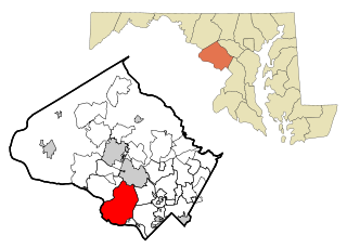
Potomac is a census-designated place (CDP) in Montgomery County, Maryland. It is named after the nearby Potomac River. Potomac is the seventh most educated small town in America, based on percentage of residents with postsecondary degrees.

Phelps is a town in Vilas County, Wisconsin, United States. The population was 1,010 in 2018. The unincorporated community of Phelps is located in the town.

Marshfield is in Wood and Marathon counties in the state of Wisconsin. It is located at the intersection of U.S. Highway 10, Highway 13 and Highway 97. The largest city in Wood County, its population was 18,929 at the 2020 census. Of this, 18,119 were in Wood County, and 810 were in Marathon County. The city is part of the United States Census Bureau's Marshfield-Wisconsin Rapids Micropolitan Statistical Area, which includes all of Wood County. The portion of the city in Marathon County is part of the Wausau Metropolitan Statistical Area.
Cypress is an unincorporated community in Harris County, Texas, United States, located completely inside the extraterritorial jurisdiction of the City of Houston. The Cypress area is located along U.S. Highway 290 is twenty-four miles (35 km) northwest of Downtown Houston. The Cypress urban cluster ranks 50th in the top 100 highest-income urban areas in the United States.

Palmyra is a census-designated place (CDP) in and the county seat of Fluvanna County, Virginia, United States. The population as of the 2010 census was 104. Palmyra lies on the eastern bank of the Rivanna River along U.S. Route 15. The ZIP code for Palmyra and surrounding rural land is 22963.

Greenleaf is an unincorporated census-designated place in Brown County, Wisconsin, United States, in the town of Wrightstown.

Highbridge is an unincorporated community located in the town of Ashland, Ashland County, Wisconsin, United States. Highbridge is located on Wisconsin Highway 13 6 miles (9.7 km) northwest of Mellen. Highbridge has a post office with ZIP code 54846. Bus service to the community is provided by Bay Area Rural Transit.

Kenney is an unincorporated community in northern Austin County, Texas, United States. According to the Handbook of Texas, the community had a population of 200 in 2000. It is located within the Greater Houston metropolitan area.

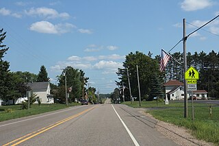
Caroline is an unincorporated census-designated place in the town of Grant in Shawano County, Wisconsin, United States. As of the 2010 census, its population is 270. The fire station for the town is located within the community. The community is located at the intersection of County Highways G & M between Marion and Tilleda. Caroline uses the ZIP code 54928. The Embarrass River passes through the community; it is used for ice racing.
The Embarrass River is a 62.0-mile-long (99.8 km) tributary of the Wolf River in the U.S. state of Wisconsin.
Phlox is an unincorporated community in the town of Norwood, Langlade County, Wisconsin, United States. It is situated on Wisconsin Highway 47 southeast of Antigo. Phlox has a post office with ZIP code 54464. In the Menominee language it is called Omāhkahkow-Menīkān which means "frog town". It lies within ancestral Menominee territory which was ceded to the United States in the 1836 Treaty of the Cedars.
Stanley is an unincorporated community in Santa Fe County, New Mexico. The ZIP code is 87056.

Moccasin is an unincorporated community in Judith Basin County, Montana, United States. The community was named for the nearby Moccasin mountain range. Moccasin has a post office with the ZIP code 59462.
Fernwood is a census-designated place and unincorporated community in Pike County, Mississippi, United States. Its ZIP code is 39635.
Zortman is a census-designated place and unincorporated community in Phillips County, Montana, United States. Its population was 69 as of the 2010 census. Zortman has a post office with ZIP code 59546.


