Wittenberg, Wisconsin

Last updated
Wittenberg, Wisconsin
2009-0620-Wittenberg.jpg
Wittenberg
Shawano County Wisconsin Incorporated and Unincorporated areas Wittenberg Highlighted.svg
Location of Wittenberg in Shawano County, Wisconsin.
Coordinates: 44°49′24″N89°9′25″W / 44.82333°N 89.15694°W / 44.82333; -89.15694 Coordinates: 44°49′24″N89°9′25″W / 44.82333°N 89.15694°W / 44.82333; -89.15694
Country Flag of the United States.svg  United States
State Flag of Wisconsin.svg  Wisconsin
County Shawano
Area
[1]
  Total1.81 sq mi (4.69 km2)
  Land1.81 sq mi (4.69 km2)
  Water0.00 sq mi (0.00 km2)
Elevation
[2]
873 ft (266 m)
Population
 (2010) [3]
  Total1,081
  Estimate 
(2019) [4]
988
  Density545.25/sq mi (210.54/km2)
Time zone UTC-6 (Central (CST))
  Summer (DST) UTC-5 (CDT)
ZIP code
54499-9033
Area code(s) 715 & 534
FIPS code 55-88350 [5]
GNIS feature ID1576924 [2]
Website http://www.villageofwittenberg.com

Wittenberg is a village in Shawano County, Wisconsin, United States. The population was 1,081 at the 2010 census. The village is located within the Town of Wittenberg.

Contents

History

In 1886, the Wittenberg Indian School was established by the Norwegian Evangelical Church of America after a purchase of land in Winnebago traditional territory. [6] [7] [8] This was a residential school for Native American children who the government removed from their families as part of an effort to assimilate Native Americans into white American culture. [7] [9] It was also known as the Bethany Indian Mission. Initial attempts to recruit students for the school were met with resistance, particularly from Winnebago "medicine men" who the missionaries believed were concerned about their intention to convert the children to Christianity. [8] The school initially only taught a few children but eventually expanded to include over a hundred students who came from the Winnebago, Oneida, Stockbridge, Brothertown, Menominee, Mohawk and Chippewa. [8] The school was sold to the government in 1900 and operated until 1917, when it was closed because of the First World War. [6] [8] After the closure of the federal school, the mission continued educating Native children, eventually educating up to 140 students with only four members of staff, as well as baptizing hundreds of local Native people. [7] [8] The high student to staff ratio was typical of overcrowded Indian schools, as documented by the Merriam Report. [6]

A post office called Wittenberg has been in operation since 1880. [10] The village was named after Wittenberg in Germany. [11]

Geography

Wittenberg is located at 44°49′25″N89°10′2″W / 44.82361°N 89.16722°W / 44.82361; -89.16722 (44.823795, -89.167328). [12]

According to the United States Census Bureau, the village has a total area of 1.79 square miles (4.64 km2), all of it land. [13]

Demographics

Historical population
CensusPop.
1890 726
1900 7989.9%
1910 1,09036.6%
1920 854−21.7%
1930 8631.1%
1940 9004.3%
1950 874−2.9%
1960 8922.1%
1970 8950.3%
1980 99711.4%
1990 1,14514.8%
2000 1,1772.8%
2010 1,081−8.2%
2019 (est.)988 [4] −8.6%
U.S. Decennial Census [14]
Water tower WittenbergWisconsinWateTower.jpg
Water tower

2010 census

As of the census [3] of 2010, there were 1,081 people, 427 households, and 231 families living in the village. The population density was 603.9 inhabitants per square mile (233.2/km2). There were 495 housing units at an average density of 276.5 per square mile (106.8/km2). The racial makeup of the village was 89.3% White, 3.8% Native American, 0.2% Asian, 5.1% from other races, and 1.7% from two or more races. Hispanic or Latino of any race were 7.1% of the population.

There were 427 households, of which 29.0% had children under the age of 18 living with them, 35.6% were married couples living together, 13.3% had a female householder with no husband present, 5.2% had a male householder with no wife present, and 45.9% were non-families. 40.5% of all households were made up of individuals, and 18.5% had someone living alone who was 65 years of age or older. The average household size was 2.19 and the average family size was 2.94.

The median age in the village was 42.2 years. 22.7% of residents were under the age of 18; 8% were between the ages of 18 and 24; 22.6% were from 25 to 44; 21% were from 45 to 64; and 25.6% were 65 years of age or older. The gender makeup of the village was 46.6% male and 53.4% female.

2000 census

As of the census [5] of 2000, there were 1,177 people, 436 households, and 272 families living in the village. The population density was 718.2 people per square mile (277.1/km2). There were 471 housing units at an average density of 287.4 per square mile (110.9/km2). The racial makeup of the village was 96.52% White, 0.17% Black or African American, 2.21% Native American, 0.08% Asian, and 1.02% from two or more races. 0.25% of the population were Hispanic or Latino of any race.

There were 436 households, out of which 32.3% had children under the age of 18 living with them, 47.5% were married couples living together, 11.0% had a female householder with no husband present, and 37.6% were non-families. 33.3% of all households were made up of individuals, and 17.9% had someone living alone who was 65 years of age or older. The average household size was 2.37 and the average family size was 3.02.

In the village, the population was spread out, with 24.8% under the age of 18, 6.5% from 18 to 24, 24.7% from 25 to 44, 15.3% from 45 to 64, and 28.7% who were 65 years of age or older. The median age was 40 years. For every 100 females, there were 87.7 males. For every 100 females age 18 and over, there were 78.8 males.

The median income for a household in the village was $29,926, and the median income for a family was $40,074. Males had a median income of $28,571 versus $21,202 for females. The per capita income for the village was $17,695. About 9.2% of families and 12.9% of the population were below the poverty line, including 14.4% of those under age 18 and 10.4% of those age 65 or over.

Economy

Notable people

Related Research Articles

Winnebago, Illinois Village in Illinois, United States

Winnebago is a village in Winnebago County, Illinois. It is part of the Rockford-Winnebago Metropolitan Statistical Area. The population was 3,101 at the 2010 census, up from 2,958 in 2000.

Winnebago, Nebraska Village in Nebraska, United States

Winnebago is a village in Thurston County, Nebraska, United States. The population was 774 at the 2010 census.

Fall River, Wisconsin Village in Wisconsin, United States

Fall River is a village in Columbia County, Wisconsin, United States, along the North Fork of the Crawfish River. The population was 1,712 at the 2010 census. It is part of the Madison Metropolitan Statistical Area.

Pardeeville, Wisconsin Village in Wisconsin, United States

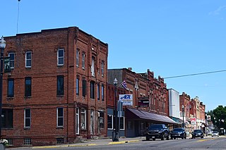
Pardeeville is a village in Columbia County, Wisconsin, United States. The population was 2,115 at the 2010 census. It is part of the Madison Metropolitan Statistical Area.

Rio, Wisconsin Village in Wisconsin, United States

Rio is a village in Columbia County, Wisconsin, United States. The population was 1,059 at the 2010 census. It is part of the Madison Metropolitan Statistical Area. The village rests primarily in the town of Otsego. The Village of Rio calls itself "Camper Country USA" due to several campgrounds located near the village. Rio is halfway between Columbus and Portage on Highway 16.

North Fond du Lac, Wisconsin Village in Wisconsin, United States

North Fond du Lac is a village in Fond du Lac County, Wisconsin, United States. The population was 5,014 at the 2010 census. Despite the name, North Fond du Lac is actually located northwest of Fond du Lac, as Lake Winnebago is directly north of Fond du Lac.

North Freedom, Wisconsin Village in Wisconsin, United States

North Freedom is a village along the Baraboo River in Sauk County, Wisconsin, United States. The population was 701 at the 2010 census.

Tigerton, Wisconsin Village in Wisconsin, United States

Tigerton is a village in Shawano County, Wisconsin, United States. The population was 741 at the 2010 census.

Poygan, Wisconsin Town in Wisconsin, United States

Poygan is a town in Winnebago County, Wisconsin, United States. The population was 1,301 at the 2010 census.

Menasha, Wisconsin City in Wisconsin, United States

Menasha is a city in Calumet and Winnebago counties in the U.S. state of Wisconsin. The population was 17,353 at the 2010 census. Of this, 15,144 were in Winnebago County, and 2,209 were in Calumet County. The city is located mostly in Winnebago County; only a small portion is in the Town of Harrison in Calumet County. Doty Island is located partially in Menasha. The city's name comes from the Winnebago word meaning "thorn" or "island". In the Menominee language, it is known as Menāēhsaeh, meaning "little island". Menasha is home to the Barlow Planetarium and Weis Earth Science Museum, both housed at the University of Wisconsin-Fox Valley.

Birnamwood, Wisconsin Village in Wisconsin, United States

Birnamwood is a village in Marathon and Shawano counties in the U.S. state of Wisconsin. It is part of the Wausau, Wisconsin Metropolitan Statistical Area. The population was 818 at the 2010 census. Of this, 802 were in Shawano County, and 16 were in Marathon County. The village is located mostly within the town of Birnamwood in Shawano County; only a small portion extends into the town of Norrie in adjacent Marathon County. Until the 1990s, Birnamwood was home to the world's largest fiberglass badger. U.S. Route 45 runs through the village.

Stockbridge, Wisconsin Village in Wisconsin, United States

Stockbridge is a village in Calumet County, Wisconsin, United States. The population was 636 at the 2010 census. The village lies within the Town of Stockbridge.

Mazomanie, Wisconsin Village in Wisconsin, United States

Mazomanie is a village in Dane County, Wisconsin, United States. The population was 1,652 at the 2010 census. The village is located within the Town of Mazomanie. It is part of the Madison Metropolitan Statistical Area.

Fox Lake, Wisconsin city in Wisconsin, United States

Fox Lake is a city in Dodge County, Wisconsin, United States. The population was 1,519 at the 2010 census. The city is located within the Town of Fox Lake.

Wonewoc, Wisconsin Village in Wisconsin, United States

Wonewoc is a village along the Baraboo River in Juneau County, Wisconsin, United States. The population was 816 at the 2010 census.

Mosinee, Wisconsin City in Wisconsin, United States

Mosinee is a city in Marathon County, Wisconsin, United States. It is part of the Wausau, Wisconsin Metropolitan Statistical Area. The population was 3,988 at the 2010 census.

Oconomowoc (town), Wisconsin Town in Wisconsin, United States

Oconomowoc is a town in Waukesha County, Wisconsin, United States. The population was 7,451 at the 2000 census. The City of Oconomowoc and the Villages of Chenequa and Lac La Belle are located partially in the town. The unincorporated communities of Mapleton, Monterey, and Okauchee Lake, are located in the town. The unincorporated community of Stone Bank is located partially in the town.

Fremont, Wisconsin Village in Wisconsin, United States

Fremont is a village in Waupaca County, Wisconsin, United States. It is surrounded by Town of Fremont. The population was 679 at the 2010 census. Fremont has been referred to as the "White Bass Capital of the World."

Scandinavia, Wisconsin Village in Wisconsin, United States

Scandinavia is a village in the Town of Scandinavia in Waupaca County, Wisconsin, United States. The population was 328 at the 2010 census.

Winneconne (town), Wisconsin Town in Wisconsin, United States

Winneconne is a town in Winnebago County, Wisconsin, United States. The population was 2,350 at the 2010 census. The Village of Winneconne is located within the town, on both sides of the Wolf River. The unincorporated community of Butte des Morts, named for a French and Native American trading war, is also located in the town. The town's water resources of rivers and lakes makes it a center of hunting and fishing, including winter ice fishing.

References

  1. "2019 U.S. Gazetteer Files". United States Census Bureau. Retrieved August 7, 2020.
  2. 1 2 "US Board on Geographic Names". United States Geological Survey. 2007-10-25. Retrieved 2008-01-31.
  3. 1 2 "U.S. Census website". United States Census Bureau . Retrieved 2012-11-18.
  4. 1 2 "Population and Housing Unit Estimates". United States Census Bureau. May 24, 2020. Retrieved May 27, 2020.
  5. 1 2 "U.S. Census website". United States Census Bureau . Retrieved 2008-01-31.
  6. 1 2 3 Bosworth, Dee Ann. "American Indian Boarding Schools: An Exploration of Global Ethnic & Cultural Cleansing" (PDF). Saginaw Chippewa Indian Tribe. Retrieved 4 July 2019.
  7. 1 2 3 "Indian schools in Wisconsin". Wisconsin Historical Society. Retrieved 4 July 2019.
  8. 1 2 3 4 5 "Bethany Indian Mission: Wittenberg, Wisconsin". WIGenWeb. Retrieved 4 July 2019.
  9. "Boarding Schools". Milwaukee Public Museum: Indian Country Wisconsin. Archived from the original on 2018-02-05. Retrieved 4 July 2019.
  10. "Shawano County". Jim Forte Postal History. Retrieved 1 April 2015.
  11. Chicago and North Western Railway Company (1908). A History of the Origin of the Place Names Connected with the Chicago & North Western and Chicago, St. Paul, Minneapolis & Omaha Railways. p. 140.
  12. "US Gazetteer files: 2010, 2000, and 1990". United States Census Bureau. 2011-02-12. Retrieved 2011-04-23.
  13. "US Gazetteer files 2010". United States Census Bureau . Retrieved 2012-11-18.
  14. "Census of Population and Housing". Census.gov. Retrieved June 4, 2015.
  15. 'Wisconsin Blue Book 1927,' Biographical Sketch of John Englund, pg. 679-680
  16. 'History of Dane County: Biographical and Genealogical,' volume 1, Elisha Williams Keyes' Western Historical Association: 1906, Hon. Jonas Swenholt, pg. 870-871
  17. 'Wisconsin Blue Book 1905,' Biographical Sketch of Joan Swenholt, pg. 1117