Gresham, Wisconsin

Last updated

Gresham, Wisconsin
GreshamWisconsinDowntownNorth.jpg
Looking north in downtown Gresham
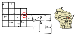
Shawano County Wisconsin Incorporated and Unincorporated areas Gresham Highlighted.svg
Location of Gresham in Shawano County, Wisconsin.
Coordinates: 44°51′0″N88°47′15″W / 44.85000°N 88.78750°W / 44.85000; -88.78750
Country Flag of the United States.svg  United States
State Flag of Wisconsin.svg  Wisconsin
County Shawano
incorporated1908
Area
[1]
  Total1.21 sq mi (3.14 km2)
  Land1.14 sq mi (2.96 km2)
  Water0.07 sq mi (0.18 km2)
Elevation
[2]
928 ft (283 m)
Population
 (2010) [3]
  Total586
  Estimate 
(2019) [4]
564
  Density494.30/sq mi (190.80/km2)
Time zone UTC-6 (Central (CST))
  Summer (DST) UTC-5 (CDT)
Area code(s) 715 & 534
FIPS code 55-31675 [5]
GNIS feature ID1581552 [2]
Website www.visit-gresham.com

Gresham is a village in Shawano County, Wisconsin, United States. The population was 586 at the 2010 census.

Contents

History

The community was named for Walter Q. Gresham, who was the Postmaster General at the time the post office opened in December, 1883. [6] Gresham was home to the Alexian Brothers' Novitiate, which after its closure was the site of a month-long occupation by the Menominee Warrior Society in 1975. [7]

Geography

Gresham is located at 44°51′11″N088°47′17″W / 44.85306°N 88.78806°W / 44.85306; -88.78806 (44.8530328, -88.7881604). [8]

According to the United States Census Bureau, the village has a total area of 1.24 square miles (3.21 km2), of which, 1.14 square miles (2.95 km2) of it is land and 0.10 square miles (0.26 km2) is water. [9]

Demographics

Historical population
CensusPop.Note
1910 350
1920 309−11.7%
1930 3100.3%
1940 295−4.8%
1950 42744.7%
1960 4587.3%
1970 448−2.2%
1980 53419.2%
1990 515−3.6%
2000 57511.7%
2010 5861.9%
2019 (est.)564 [4] −3.8%
U.S. Decennial Census [10]

2010 census

As of the census [3] of 2010, there were 586 people, 239 households, and 145 families living in the village. The population density was 514.0 inhabitants per square mile (198.5/km2). There were 280 housing units at an average density of 245.6 per square mile (94.8/km2). The racial makeup of the village was 67.9% White, 0.2% African American, 24.1% Native American, 0.7% from other races, and 7.2% from two or more races. Hispanic or Latino of any race were 3.2% of the population.

There were 239 households, of which 31.4% had children under the age of 18 living with them, 39.3% were married couples living together, 16.3% had a female householder with no husband present, 5.0% had a male householder with no wife present, and 39.3% were non-families. 33.5% of all households were made up of individuals, and 16.4% had someone living alone who was 65 years of age or older. The average household size was 2.45 and the average family size was 3.12.

The median age in the village was 36.7 years. 27.5% of residents were under the age of 18; 9% were between the ages of 18 and 24; 23.7% were from 25 to 44; 20.1% were from 45 to 64; and 19.6% were 65 years of age or older. The gender makeup of the village was 49.1% male and 50.9% female.

2000 census

As of the census [5] of 2000, there were 575 people, 233 households, and 143 families living in the village. The population density was 503.3 people per square mile (194.7/km2). There were 257 housing units at an average density of 225.0 per square mile (87.0/km2). The racial makeup of the village was 68.70% White, 0.17% African American, 23.48% Native American, 0.52% from other races, and 7.13% from two or more races. Hispanic or Latino of any race were 2.09% of the population.

There were 233 households, out of which 32.2% had children under the age of 18 living with them, 41.2% were married couples living together, 15.0% had a female householder with no husband present, and 38.6% were non-families. 34.3% of all households were made up of individuals, and 17.6% had someone living alone who was 65.

Education

Gresham is home to two public schools which serve 282 students. [11]

Images

Related Research Articles

<span class="mw-page-title-main">Shawano County, Wisconsin</span> County in Wisconsin, United States

Shawano County is a county located in the U.S. state of Wisconsin. As of the 2020 census, the population was 40,881. Its county seat is Shawano.

<span class="mw-page-title-main">Oconto County, Wisconsin</span> County in Wisconsin, United States

Oconto County is a county in the U.S. state of Wisconsin. As of the 2020 census, the population was 38,965. Its county seat is Oconto. The county was established in 1851.

<span class="mw-page-title-main">Menominee County, Wisconsin</span> County in Wisconsin, United States

Menominee County is a county in the U.S. state of Wisconsin. As of the 2020 census, the population was 4,255, making it the least populous county in Wisconsin. Its county seat is in the community of Keshena.

<span class="mw-page-title-main">White Lake, Wisconsin</span> Village in Wisconsin, United States

White Lake is a village in Langlade County, Wisconsin, United States. The population was 363 at the 2010 census.

<span class="mw-page-title-main">Bonduel, Wisconsin</span> Village in Wisconsin, United States

Bonduel is a village in Shawano County, Wisconsin, United States. The population was 1,478 at the 2010 census.

<span class="mw-page-title-main">Bowler, Wisconsin</span> Village in Wisconsin, United States

Bowler is a village in Shawano County, Wisconsin, United States. The population was 302 at the 2010 census.

<span class="mw-page-title-main">Cecil, Wisconsin</span> Village in Wisconsin, United States

Cecil is a village in Shawano County, Wisconsin, United States. The population was 570 at the 2010 census.

<span class="mw-page-title-main">Eland, Wisconsin</span> Village in Wisconsin, United States

Eland is a village in Shawano County, Wisconsin, in the United States. The population was 202 at the 2010 census.

<span class="mw-page-title-main">Green Valley, Shawano County, Wisconsin</span> Town in Wisconsin, United States

Green Valley is a town in Shawano County, Wisconsin, United States. The population was 1,024 at the 2000 census. The census-designated place of Green Valley and unincorporated communities of Advance and Pulcifer are located in the town.

<span class="mw-page-title-main">Navarino, Wisconsin</span> Town in Wisconsin, United States

Navarino is a town in Shawano County, Wisconsin, United States. As of the 2010 census, its population is 177. For statistical purposes, the United States Census Bureau has defined Navarino as a census-designated place (CDP). The census-designated place and community of Navarino is located in the town.

<span class="mw-page-title-main">Pella, Wisconsin</span> Town in Wisconsin, United States

Pella is a town in Shawano County, Wisconsin, United States. The population was 877 at the 2000 census. The unincorporated community of Leopolis is located partially within the town. There is a census-designated place also called Pella in the town.

<span class="mw-page-title-main">Red Springs, Wisconsin</span> Town in Wisconsin, United States

Red Springs is a town in Shawano County, Wisconsin, United States. As of the 2010 census, the town had a total population of 925. The unincorporated community of Morgan is located in the town. The census-designated place of Middle Village is also located partially in the town.

<span class="mw-page-title-main">Shawano, Wisconsin</span> City in Wisconsin, United States

Shawano is a city in Shawano County, Wisconsin, United States. The population was 9,243 at the 2020 census. It is the county seat of Shawano County.

<span class="mw-page-title-main">Wescott, Wisconsin</span> Town in Wisconsin, United States

Wescott is a town in Shawano County, Wisconsin, United States. The population was 3,653 at the 2000 census.

<span class="mw-page-title-main">Embarrass, Wisconsin</span> Village in Wisconsin, United States

Embarrass is a village in Waupaca County, Wisconsin, United States. The population was 404 at the 2010 census.

<span class="mw-page-title-main">Middle Village, Wisconsin</span> CDP in Wisconsin, United States

Middle Village is a census-designated place (CDP), in the towns of Menominee and Red Springs, in Menominee and Shawano counties in the U.S. state of Wisconsin. It does not have any legal status as an incorporated municipality. The population was 290 at the 2020 census.

<span class="mw-page-title-main">Pulaski, Wisconsin</span> Village in Wisconsin, United States

Pulaski is a village in Brown, Oconto, and Shawano counties in the U.S. state of Wisconsin. The population was 3,539 at the 2010 census. Of this, 3,321 were in Brown County, 218 in Shawano County, and none in Oconto County.

<span class="mw-page-title-main">Birnamwood, Wisconsin</span> Village in Wisconsin, United States

Birnamwood is a village in Marathon and Shawano counties in the U.S. state of Wisconsin. It is part of the Wausau, Wisconsin Metropolitan Statistical Area. The population was 818 at the 2010 census. Of this, 802 were in Shawano County, and 16 were in Marathon County. The village is located mostly within the town of Birnamwood in Shawano County; only a small portion extends into the town of Norrie in adjacent Marathon County.

Wittenberg is a town in Shawano County, Wisconsin, United States. As of the 2000 census, the town had a total population of 894. The Village of Wittenberg is located within the town. The unincorporated community of Whitcomb is also located within the town.

<span class="mw-page-title-main">Wittenberg, Wisconsin</span> Village in Wisconsin, United States

Wittenberg is a village in Shawano County, Wisconsin, United States. The population was 1,081 at the 2010 census. The village is located within the Town of Wittenberg.

References

  1. "2019 U.S. Gazetteer Files". United States Census Bureau. Retrieved August 7, 2020.
  2. 1 2 "US Board on Geographic Names". United States Geological Survey. October 25, 2007. Retrieved January 31, 2008.
  3. 1 2 "U.S. Census website". United States Census Bureau . Retrieved November 18, 2012.
  4. 1 2 "Population and Housing Unit Estimates". United States Census Bureau. May 24, 2020. Retrieved May 27, 2020.
  5. 1 2 "U.S. Census website". United States Census Bureau . Retrieved January 31, 2008.
  6. Callary, Edward (2016). Place Names of Wisconsin. Madison, WI: University of Wisconsin Press. p. 111. ISBN   978-0-299-30964-0.
  7. Pulaski, Lee (January 24, 2012). "Remembering the Novitiate - Shawano Leader - Shawano, WI". Archived from the original on January 24, 2012. Retrieved January 14, 2024.
  8. "Gresham". Geographic Names Information System . United States Geological Survey, United States Department of the Interior . Retrieved May 3, 2009.
  9. "US Gazetteer files 2010". United States Census Bureau. Archived from the original on January 25, 2012. Retrieved November 18, 2012.
  10. "Census of Population and Housing". Census.gov. Retrieved June 4, 2015.
  11. "Gresham School District". U.S. News and World Report. Retrieved January 14, 2024.