Maple Grove, Shawano County, Wisconsin

Last updated

Maple Grove, Wisconsin
WIMap-doton-Maple Grove c.png
Location of Maple Grove, Shawano County, Wisconsin
Coordinates: 44°36′45″N88°18′27″W / 44.61250°N 88.30750°W / 44.61250; -88.30750
Country Flag of the United States.svg  United States
State Flag of Wisconsin.svg  Wisconsin
County Shawano
Area
  Total35.3 sq mi (91.5 km2)
  Land35.3 sq mi (91.5 km2)
  Water0.0 sq mi (0.0 km2)
Elevation
[1]
869 ft (265 m)
Population
 (2000)
  Total1,045
  Density29.6/sq mi (11.4/km2)
Time zone UTC-6 (Central (CST))
  Summer (DST) UTC-5 (CDT)
FIPS code 55-48900 [2]
GNIS feature ID1583644 [1]

Maple Grove is a town in Shawano County, Wisconsin, United States. The population was 1,045 at the 2000 census. The unincorporated communities of Hofa Park, Laney, and Rose Lawn are located in the town. The unincorporated communities of Angelica, Frazer Corners, and Pittsfield are also located partially in the town.

Contents

Geography

According to the United States Census Bureau, the town has a total area of 35.3 square miles (91.5 km2), of which, 35.3 square miles (91.5 km2) of it is land and 0.03% is water.

Demographics

As of the census [2] of 2000, there were 1,045 people, 360 households, and 297 families residing in the town. The population density was 29.6 people per square mile (11.4/km2). There were 372 housing units at an average density of 10.5 per square mile (4.1/km2). The racial makeup of the town was 99.04% White, 0.29% Native American, 0.29% Asian, and 0.38% from two or more races. Hispanic or Latino of any race were 1.05% of the population.

There were 360 households, out of which 36.1% had children under the age of 18 living with them, 73.1% were married couples living together, 5.0% had a female householder with no husband present, and 17.5% were non-families. 13.6% of all households were made up of individuals, and 6.7% had someone living alone who was 65 years of age or older. The average household size was 2.90 and the average family size was 3.21.

In the town, the population was spread out, with 27.0% under the age of 18, 7.5% from 18 to 24, 29.9% from 25 to 44, 22.5% from 45 to 64, and 13.2% who were 65 years of age or older. The median age was 37 years. For every 100 females, there were 101.3 males. For every 100 females age 18 and over, there were 106.2 males.

The median income for a household in the town was $45,568, and the median income for a family was $52,625. Males had a median income of $31,944 versus $23,500 for females. The per capita income for the town was $16,818. About 3.2% of families and 5.5% of the population were below the poverty line, including 6.9% of those under age 18 and 2.7% of those age 65 or over.

Related Research Articles

<span class="mw-page-title-main">Las Lomas, California</span> Census-designated place in California, United States

Las Lomas is an unincorporated community and census-designated place (CDP) in Monterey County, California, United States. Las Lomas is located 7 miles (11 km) north-northwest of Prunedale. The elevation is 43 feet (13 m). The population was 3,046 at the 2020 census.

<span class="mw-page-title-main">Grove City, Florida</span> Census-designated place in Florida, United States

Grove City is an unincorporated community and census-designated place (CDP) in Charlotte County, Florida, United States. The population was 2,174 at the 2020 census. It is part of the Sarasota-Bradenton-Punta Gorda Combined Statistical Area.

<span class="mw-page-title-main">Poseyville, Indiana</span> Town in Indiana, United States

Poseyville is a town in Robb Township, Posey County, in the U.S. state of Indiana. The population was 1,045 at the 2010 census.

<span class="mw-page-title-main">Belleville, Kansas</span> City in Republic County, Kansas

Belleville is a city in and the county seat of Republic County, Kansas, United States. As of the 2020 census, the population of the city was 2,007.

Princeton is a town in Washington County, Maine, United States. The town was named after Princeton, Massachusetts. The population was 745 at the 2020 census.

Hamlin Township is a civil township of Eaton County in the U.S. state of Michigan. The population was 3,227 at the 2020 census.

<span class="mw-page-title-main">Tilden Township, Michigan</span> Civil township in Michigan, United States

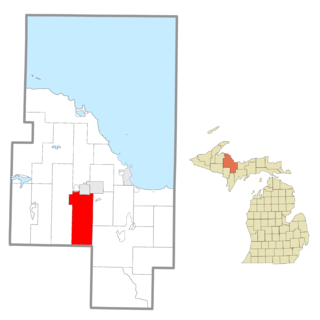
Tilden Township is a civil township of Marquette County in the U.S. state of Michigan. The population was 1,045 at the 2020 census.

<span class="mw-page-title-main">Lowell, Oregon</span> City in Oregon, United States

Lowell is a city in Lane County, in the U.S. state of Oregon. As of the 2010 census, the city population was 1,045. The city is on the north shore of Dexter Reservoir on the Middle Fork Willamette River. The most used route to Lowell is along Lowell Bridge, a covered bridge that crosses the reservoir from Oregon Route 58.

<span class="mw-page-title-main">Madison Township, Lackawanna County, Pennsylvania</span> Place in Pennsylvania, United States

Madison Township is a township in Lackawanna County, Pennsylvania, United States. The population was 2,476 at the 2020 census. Madisonville and Quicktown are part of Madison Township.

<span class="mw-page-title-main">Bolivar, West Virginia</span> Town in West Virginia, United States

Bolivar is a town in Jefferson County, West Virginia, United States. The population was 1,072 at the 2020 census. The town is named for South American revolutionary leader Simón Bolívar. Located in West Virginia's Eastern Panhandle, it is part of the northwestern fringes of the Washington metropolitan area.

<span class="mw-page-title-main">Rhodell, West Virginia</span> Unincorporated community in West Virginia, United States

Rhodell is an unincorporated community in Raleigh County, West Virginia, United States. The population was 173 at the 2010 census.

<span class="mw-page-title-main">Glenmore, Wisconsin</span> Town in Wisconsin, United States

Glenmore is a town in Brown County in the U.S. state of Wisconsin. The population was 1,045 at the 2020 census.

<span class="mw-page-title-main">Oakland, Burnett County, Wisconsin</span> Town in Wisconsin, United States

Oakland is a town in Burnett County in the U.S. state of Wisconsin. The population was 827 at the 2010 census. It is along Wisconsin Highway 35. The unincorporated communities of Oakland and Yellow Lake are located in the town.

<span class="mw-page-title-main">Calamus, Wisconsin</span> Town in Wisconsin, United States

Calamus is a town in Dodge County, Wisconsin, United States. The population was 1,005 at the 2000 census. The unincorporated community of South Beaver Dam is located in the town. The unincorporated community of Lost Lake is also located partially in the town.

<span class="mw-page-title-main">Rubicon, Wisconsin</span> Town in Wisconsin, United States

Rubicon is a town in Dodge County, Wisconsin, United States. The population was 2,005 at the 2000 census. The unincorporated communities of Rubicon and Saylesville are located in the town. The unincorporated community of Woodland is also located partially in the town.

<span class="mw-page-title-main">Hawthorne, Wisconsin</span> Town in Wisconsin, United States

Hawthorne is a town in Douglas County, Wisconsin, United States. The population was 1,045 at the 2000 census. The unincorporated communities of Dobie, Hawthorne, Hillcrest, and Hines are located in the town.

<span class="mw-page-title-main">Neva, Wisconsin</span> Town in Wisconsin, United States

Neva is a town in Langlade County, Wisconsin, United States. The population was 902 at the 2010 census, down from 994 at the 2000 census. The unincorporated communities of Deerbrook, Kempster, Neva, and Neva Corners are located in the town.

<span class="mw-page-title-main">Angelo, Wisconsin</span> Town in Wisconsin, United States

Angelo is a town in Monroe County, Wisconsin, United States. The population was 1,268 at the 2000 census. The unincorporated community of Farmers Valley is also located partially in the town.

<span class="mw-page-title-main">Wheatland, Vernon County, Wisconsin</span> Town in Vernon County, Wisconsin, United States

Wheatland is a town in Vernon County, Wisconsin, United States. The population was 533 at the 2000 census. The unincorporated communities of Red Mound, and Victory are located in Wheatland.

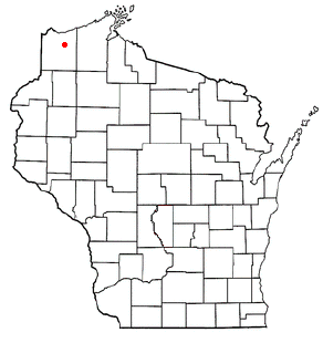
The Town of Clayton is located in Polk County, Wisconsin, United States. The population was reported as 958 in 2020 according to the 2020 US census. The Village of Clayton is distinct and contains its own leadership but shares the same school district as the town. The town contains the unincorporated communities of Joel and Richardson.

References

  1. 1 2 "US Board on Geographic Names". United States Geological Survey. October 25, 2007. Retrieved January 31, 2008.
  2. 1 2 "U.S. Census website". United States Census Bureau . Retrieved January 31, 2008.