Meteorological history | |
---|---|
Formed | September 22,2021 |
Dissipated | September 26,2021 |
Tropical storm | |
10-minute sustained (JMA) | |
Highest winds | 65 km/h (40 mph) |
Lowest pressure | 1000 hPa (mbar);29.53 inHg |
Tropical storm | |
1-minute sustained (SSHWS/JTWC) | |
Highest winds | 65 km/h (40 mph) |
Lowest pressure | 1001 hPa (mbar);29.56 inHg |
Overall effects | |
Fatalities | 8 |
Missing | 5 |
Damage | Unknown |
Areas affected | Vietnam,Laos,Thailand |
IBTrACS | |
Part of the 2021 Pacific typhoon season |
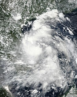
Tropical Storm Dianmu was a weak tropical cyclone that caused considerable damage over parts of Mainland Southeast Asia during late-September 2021. The fifteenth named storm of the 2021 Pacific typhoon season,Dianmu originated from an area of low-pressure situated in the South China Sea on September 21. Being first monitored by the Joint Typhoon Warning Center,the system rapidly consolidated to a tropical depression on September 22 as it continued to approach Vietnam before strengthening further to a weak tropical storm,with the Japan Meteorological Agency naming it as "Dianmu". Little intensification occurred before it made landfall on the country with winds of 35 knots (65 km/h;40 mph). It then rapidly weakened over land and dissipated on September 24 as a tropical cyclone.
Heavy rains resulted in severe flooding in Vietnam and Thailand,as well as affecting Laos during its lifespan. Many livestock and agricultural lands were also affected,along with over 300,000 people. 8 people were killed and 5 were missing due to Dianmu's onslaught. A short-lived storm,after it crossed into the Mainland Southeast Asia,its remnants emerged into the Bay of Bengal and affected the West Bengal.
On September 21 at 21:00 UTC, the United States Joint Typhoon Warning Center (JTWC) [nb 1] started to monitor an area of low-pressure in the South China Sea, 168 nmi (311 km; 193 mi) to the northwest of Puerto Princesa, Philippines. At that time, infrared imagery revealed a low-level circulation center being defined and organized with its convection onto its western semicircle. Environmental analysis on the area depicted a favorable path for tropical cyclogenesis, with low wind shear, good outflow and warm 29–30 °C (84–86 °F) sea surface temperatures. However, at that time, the agency only estimated the system's probability of development to “low” as forecast ensembles only indicated a slow formation of the storm in the next 24 hours until 09:30 UTC on the next day, when they raised it to “medium” and subsequently upgraded it to a tropical depression at 15:00 UTC that day. [2] [3] [4] However, the Japan Meteorological Agency [nb 2] did the same three hours later. [6]
A rapidly organizing system, the depression was steered west-northwestward by the southern periphery of a low to mid-level subtropical ridge to the north. [7] As it neared the coast of Vietnam, the JMA further upgraded the depression to a tropical storm, assigning it the name Dianmu from its naming lists at 06:00 UTC on September 23; the JTWC did the same three hours later based on microwave images and radar coverage. [8] [9] As Dianmu made landfall over the Vietnamese provinces of Thua Thien Hue and Quang Ngai on the early hours of September 24 with winds of 35 knots (65 km/h; 40 mph), the JTWC issued its final bulletin on the storm as it weakened considerably over the country at 15:00 UTC, although it remained a tropical storm upon its final issuance. [10] [11] The JMA, meanwhile, downgraded Dianmu back to a tropical depression twelve hours later before it issued its final warning on the system as it dissipated as a remnant low at 12:00 UTC on September 24. [12] [13] However, its remnants crossed into the Bay of Bengal, where it intensified to a low-pressure area before it moved inland for the second time over West Bengal. [14] [15] [16]
Dianmu and its resulting floods killed 8 individuals across Thailand and Vietnam while 5 were reported to have been missing. 73,938 families (369,690 individuals) were affected by the storm and heavy rainfall had caused flooding in these countries. [17] [18]
On September 23, Le Van Thanh, the National Steering Committee for Natural Disaster Prevention and Control (NSCNDPC) Deputy Prime Minister, conducted an online meeting with the leaders of People's Committee of various districts to discuss the storm's potential impacts. There, preparations discussed included the sending information to the remaining 28 ships in the waters off Quang Binh to Bình Thuận and the Covid-19 testing of vessel crews and sheltering their boats. Evacuation of individuals in Quảng Nam were discussed, along with the advice of the People's Committee of the province to store food and important necessities for 7–10 days. The People's Committee of Da Nang also reminded its people to remain in their houses and not to venture outside while the storm is passing. [19] [20]
On a six-hour period of September 23, 155.4 mm (6.12 in) of rainfall was recorded at Bình Sơn District in Quảng Ngãi and 134.2 mm (5.28 in) on Sơn Hà District in the same province. [21] The system also likely spawned two tornados in the country, one in Núi Thành District, Quảng Nam Province on September 23 in which it caused roof and household damages, including a school. An individual was injured. The other one was in Duy Phước, which damaged another elementary school. [22] Strong winds also uprooted trees and damaged houses in some coastal communities in Nui Thanh while the authorities in Tam Tien evacuated people that are located in damaged houses and other dangerous areas. Residential areas near the Tra Bong River and Quảng Ngãi were flooded while 7 houses collapsed as a result of the storm in Binh Dong, Binh Son district. Ly Son Island suffered damages to 300 hectares of onions and garlic and 10 houses in a village there. [19] [23] A 2,000-ton cargo ship collided with a fishing boat on the coast of Bình Định Province on September 24, leaving 2 fishermen missing out of the three of the latter which was rescued. The vessel was severely damaged following the accident. [24] 2 more children drowned in Tuy Phuoc district, Binh Dinh after they slipped in a lake to collect bottles floating. [25] Another fisherman was reported missing. [17]
As of September 25, over 2,845 families (14,225 individuals) were affected by Dianmu, 2725 houses and 3,734 ha of agricultural crops and lands being damaged, 201 roads and 5 schools suffering significant destruction and 5,402 livestock being reported to have been killed. [17]
The influence of the remnants of Dianmu, that moved with the monsoon trough that persisted in Northeast and Central regions of the country caused heavy rainfall in its upper regions and 30 more areas in the said zones. 202 mm (8.0 in) of rain was reported in Tak Fa, Nakhon Sawan Province and Phliu, Chanthaburi Province at 182 mm (7.2 in) in a 24-hour period from September 23–24. 10 areas in the country also recorded an increase in water level of its rivers. The levels of dams and reservoirs in 11 locations were also critical. The authorities in the capital Bangkok installed water pumps and barriers to help subside floods. 71,093 households (355,465 persons) were affected with the flash floods. [17] [18] The Chao Phraya River in Bangkok also saw an increase in its water level due to rains. Thai servicemen gathered to fill sandbags to protect the Wat Chaiwatthanaram in Ayutthaya Historical Park. Thai Prime Minister Prayut Chan-o-cha visited the flood-stricken areas, especially Sukhothai on an unknown day as a result. Six individuals in the area were killed by the floods and two more were missing. [26]
In Laos, the National Disaster Management Organisastion (NDMO) reported that Dianmu affected several provinces in the country, although they are still continuing to assess the damages from the storm there as of September 28. [17]
Typhoon Dianmu, known in the Philippines as Typhoon Helen, was a powerful typhoon that struck southeastern Japan during the 2004 Pacific typhoon season. The name Dianmu is the name of the goddess of thunder and lightning in Chinese folklore.
The September 2009 Vietnam tropical depression was a weak tropical depression that caused deadly flooding throughout central Vietnam in early September. Forming out of an area of low pressure on September 3, the depression hardly intensified as it meandered off the coast of Vietnam. Initially situated in a favorable environment, convective banding features began to develop and shower and thunderstorm activity formed near the center. On September 4, the Joint Typhoon Warning Center issued a Tropical Cyclone Formation Alert; however, a sudden increase in wind shear caused the system to rapidly become disorganized, leading to the cancellation of the alert the next day. The system continued to slowly track off the coast of Vietnam, nearly dissipating on September 5, before becoming better organized. However, the depression remained weak, with the JTWC reporting on September 7 that the depression had dissipated, though the Japan Meteorological Agency (JMA) continued to issue advisories until the depression dissipated during September 9.
The 2016 Pacific typhoon season is considered to have been the fourth-latest start for a Pacific typhoon season since reliable records began. It was an average season, with a total of 26 named storms, 13 typhoons, and six super typhoons. The season ran throughout 2016, though typically most tropical cyclones develop between May and October. The season's first named storm, Nepartak, developed on July 3, while the season's last named storm, Nock-ten, dissipated on December 28.
The 2020 Pacific typhoon season was the first of an ongoing series of below average Pacific typhoon seasons, and became the first with below-average tropical cyclone activity since 2014, with 23 named storms, 10 of which became typhoons and only 2 became super typhoons. This low activity was a consequence of La Niña that persisted from the summer of the year. It had the sixth-latest start in the basin on record, slightly behind 1973, and was the first to start that late since 2016. The first half of the season was unusually inactive, with only four systems, two named storms and one typhoon at the end of July. Additionally, the JTWC recorded no tropical cyclone development in the month of July, the first such occurrence since reliable records began. The season's first named tropical cyclone, Vongfong, developed on May 8, while the season's last named tropical cyclone, Krovanh, dissipated on December 24. However, the season's last system was an unnamed tropical depression which dissipated on December 29.
Tropical Depression 18W was a tropical depression that impacted Vietnam, Laos and Thailand during mid September 2013. The system was first noted as a tropical depression on September 16, 2013, while it was located within the South China Sea to the south east of Hanoi in Vietnam. Over the next two days the system gradually developed further, before it was reported by the Vietnamese National Centre for Hydro Meteorological Forecasting that the system had developed into their eighth tropical storm of 2013. However, other meteorological agencies did not report that the system had developed into a tropical storm.
Tropical Storm Vamco was a weak tropical cyclone which affected Indochina in mid-September 2015. Formed from a tropical disturbance on September 13, the system developed into a tropical storm and reached its peak intensity on September 14. Vamco made landfall in Vietnam and affected Laos, Thailand and Cambodia. The storm caused flooding in these countries and damages amounted to US$14.1 million. Fifteen people died in the floods.
Tropical Storm Dianmu was a weak tropical cyclone that struck Leizhou Peninsula, China and Northern Vietnam in mid August 2016. It was the eighth named storm of the annual typhoon season.
Tropical Storm Rai was a weak and short-lived tropical cyclone which affected Indochina in September 2016. Formed from a tropical disturbance on September 11, the system developed into a tropical storm and reached its peak intensity on September 12, before making landfall in Vietnam and affecting Laos, Thailand and Cambodia. In Vietnam total damage reached US$73.96 million.
Typhoon Chaba, known in the Philippines as Super Typhoon Igme, was the fourth most intense tropical cyclone in 2016 and the strongest tropical cyclone to make landfall in South Korea since Sanba in 2012. Chaba also caused 7 deaths in the country. Typhoon Chaba was the eighteenth named storm and the eighth typhoon of the 2016 Pacific typhoon season. Chaba originated as a depression around the east-northeast of Guam. Being in a marginally favorable environment, JMA proceeds to name the system as Chaba. On September 28, JTWC gave its identifier as Tropical Depression 21W. Its LLCC starts to improve, prompting the JTWC to upgrade into a tropical storm. Chaba entered the Philippine Area of Responsibility, receiving the name Igme as it moved northwestwards. Chaba became more symmetrical which later ensued its rapid intensification.
Severe Tropical Storm Aere, known in the Philippines as Tropical Storm Julian, was a long-lived tropical cyclone that struck Central Vietnam in October 2016. The nineteenth named storm of the annual typhoon season, Aere formed on October 4, 2016 as a tropical depression to the east of Luzon, Philippines shortly after the JMA had started tracking Songda. On the next day, the system had become a tropical storm and it moved into South China Sea. During October 7, it intensified into a severe tropical storm and reached peak intensity with 10-minute winds of 110 km/h (70 mph). Shortly thereafter, due to remaining in almost the same area for hours, Aere began to weaken to a tropical storm, and on October 10, it weakened to a tropical depression, before weakening to a low-pressure area late on October 11. On October 13, Aere re-generated into a tropical depression and it made landfall in Huế, Vietnam late that day. The system moved towards Laos and Thailand before it fully dissipated on October 14.
Typhoon Doksuri, known in the Philippines as Tropical Storm Maring, was a strong Category 2 typhoon that mostly impacted the Philippines and Vietnam during mid-September 2017. Forming as the nineteenth named storm of the season, Doksuri developed as a weak tropical depression over to the east of Visayas on September 10.
The 2021 Pacific typhoon season was the second consecutive to have below average tropical cyclone activity, with twenty-two named storms, and was the least active since 2011. Nine became typhoons, and five of those intensified into super typhoons. This low activity was caused by a strong La Niña that had persisted from the previous year. The season's first named storm, Dujuan, developed on February 16, while the last named storm, Rai, dissipated on December 21. The season's first typhoon, Surigae, reached typhoon status on April 16. It became the first super typhoon of the year on the next day, also becoming the strongest tropical cyclone in 2021. Surigae was also the most powerful tropical cyclone on record in the Northern Hemisphere for the month of April. Typhoons In-fa and Rai are responsible for more than half of the total damage this season, adding up to a combined total of $2.02 billion.
The 2022 Pacific typhoon season was the third consecutive season to have below average tropical cyclone activity, with twenty-five named storms forming. Of the tropical storms, ten became typhoons, and three would intensify into super typhoons. The season saw near-average activity by named storm count, although many of the storms were weak and short-lived, particularly towards the end of the season. This low activity was caused by an unusually strong La Niña that had persisted from 2020. The season's first named storm, Malakas, developed on April 6, while the last named storm, Pakhar, dissipated on December 12. The season's first typhoon, Malakas, reached typhoon status on April 12. The season ran throughout 2022, though most tropical cyclones typically develop between May and October. Tropical storms Megi and Nalgae were responsible for more than half of the casualties, while typhoons Hinnamnor and Nanmadol both caused $1 billion in damages.
Tropical Storm Sinlaku was a weak tropical cyclone that impacted Vietnam, Thailand and Laos in August 2020. Beginning as a tropical depression on July 31 in the South China Sea, Sinlaku was the fifth storm of the 2020 Pacific typhoon season. It gradually organized as it took a slow west-northwest course, strengthening into a tropical storm the following day despite its monsoonal structure. The storm subsequently made landfall in Vietnam as a broad but weak tropical storm. Persistent land interaction weakened Sinlaku, leading to its dissipation on August 3.
Tropical Storm Noul, also known in the Philippines as Tropical Storm Leon, was a weak, but deadly tropical cyclone that impacted central Vietnam, which had been affected by Tropical Storm Sinlaku more than one month earlier. Noul originated from a tropical system in the Philippine Sea in September 15. The system was upgraded into a tropical depression later that same day by JMA, with JTWC and PAGASA following suit in 15:00 UTC, with PAGASA assigning the local name Leon to the developing tropical cyclone. As Leon was leaving the area of responsibility, Leon intensified into a tropical storm and was assigned the international name Noul by JMA. Noul would make landfall between Quảng Trị and Thừa Thiên-Huế provinces in September 18 before degenerating into a remnant low over Thailand later that day.
Severe Tropical Storm Usagi, known in the Philippines as Tropical Storm Samuel, was a tropical cyclone that affected the Philippines and Southern Vietnam in late November 2018, causing severe damage around the Visayas region and Ho Chi Minh City. The storm formed from a disturbance in the Central Pacific basin on November 3, but did not develop into a tropical storm until almost three weeks later, on November 13. Usagi underwent rapid intensification and peaked in intensity before making its final landfall on Vũng Tàu, Bà Rịa–Vũng Tàu province as a weakening tropical storm on November 25. While never considered as a typhoon by the Japan Meteorological Agency (JMA), the Joint Typhoon Warning Center (JTWC) assessed its intensity to be equivalent to Category 2 status on the Saffir–Simpson scale. Usagi caused one death and ₱52.2 million (US$992,000) in damages in the Philippines, most of which came from agriculture. Usagi caused 3 deaths and ₫925 billion in damages in Vietnam.
Tropical Storm Linfa was a weak, short-lived but deadly and destructive tropical cyclone that was the twelfth wettest tropical cyclone on record and the second of nine tropical cyclones in a row to strike Vietnam in 2020, a little under a month after the less damaging Tropical Storm Noul. The fifteenth named storm of the 2020 Pacific typhoon season, Linfa originated from a tropical depression which formed just to the west of the Philippines on October 6. After passing through the island nation, the storm emerged into the South China Sea and slowly gained strength, earning the name Linfa on October 10 on approach to Vietnam. On the next day, Linfa had reached peak strength and made landfall in Vietnam, marking the beginning of a devastating series of floods in the country and worsening the already active monsoon season. Linfa quickly dissipated as it moved inland, but associated thunderstorms continued for several days.
Severe Tropical Storm Conson, known in the Philippines as Typhoon Jolina, was a strong tropical cyclone that impacted the central Philippines and Vietnam during the 2021 Pacific typhoon season. Being the thirteenth named storm of the said event, Conson originated as a low-pressure area first monitored approximately 500 km (310 mi) west of Guam. It formed as a tropical depression over the Pacific Ocean on September 5, 2021. As it formed within the Philippine Area of Responsibility, the Philippine Atmospheric, Geophysical, and Astronomical Services Administration (PAGASA) named the storm Jolina. Over the next day, it intensified into a tropical storm and was named Conson by the Japan Meteorological Agency (JMA). As the storm neared Samar Island, it intensified into a severe tropical storm, and later into a typhoon according to the PAGASA prior to its first landfall in Eastern Samar. The storm retained its strength as it crossed Visayas and later Calabarzon before weakening over Manila Bay prior to its final landfall in Bataan. It subsequently emerged into the South China Sea where it struggled to reintensify further. It then weakened into a tropical depression just offshore of Vietnam before moving ashore near Da Nang. It then rapidly weakened before dissipating on September 13.
Vietnam is a southeast Asian country, and is the easternmost country of mainland Southeast Asia. It borders the East Sea, hence, seeing the increased likeliness of tropical cyclones. Tropical cyclones in this area are considered to be part of the Northwest Pacific basin, and therefore, storms here are considered as typhoons.
Tropical Storm Haitang was a weak tropical cyclone which impacted China and Southeast Asia. The nineteenth named storm of the below-average 2011 Pacific typhoon season, Haitang developed from a disturbance in the South China Sea. After being recognized as a tropical depression on September 24, Haitang would peak as a minimal tropical storm before making landfall in Hue, Vietnam. Haitang would rapidly weaken once inland, dissipating in Laos in September 27.