
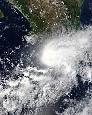
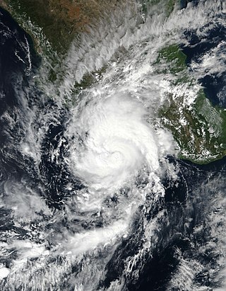
Hurricane Barbara was the easternmost landfalling Pacific hurricane on record. As the first hurricane of the 2013 Pacific hurricane season, Barbara developed from a low-pressure area while located southeast of Mexico on May 28. It headed slowly north-northeastward and strengthened into a tropical storm early on the following day. After recurving to the northeast, Barbara intensified into a Category 1 hurricane on May 29 and made landfall in Chiapas at peak intensity with winds of 80 mph (130 km/h) and a barometric pressure estimated at 983 mbar. When the hurricane made landfall, it was the second earliest landfalling hurricane in the basin since reliable records began in 1966. Barbara then moved across the Isthmus of Tehuantepec and dissipated within the mountainous terrain of Sierra Madre de Chiapas on May 30.

Tropical Storm Carlos was the first of five tropical cyclones to make landfall during the 2003 Pacific hurricane season. It formed on June 26 from a tropical wave to the south of Mexico. It quickly strengthened as it approached the coast, and early on June 27 Carlos moved ashore in Oaxaca with winds of 65 mph (105 km/h). The storm rapidly deteriorated to a remnant low, which persisted until dissipating on June 29. Carlos brought heavy rainfall to portions of southern Mexico, peaking at 337 mm (13.3 in) in two locations in Guerrero. Throughout its path, the storm damaged about 30,000 houses, with a monetary damage total of 86.7 million pesos. At least nine people were killed throughout the country, seven due to mudslides and two from river flooding; there was also a report of two missing fishermen.

The 2013 Pacific hurricane season was an above average Pacific hurricane season with 21 tropical cyclones forming. Of these, 20 became named storms – 18 in the Eastern Pacific basin, and 2 in the Central Pacific basin. Of the 18 named storms in the east, 9 became hurricanes, with one, Raymond, becoming the season's only major hurricane. In the central, neither named storm became a hurricane. It was also a below-normal season in terms of Accumulated cyclone energy (ACE), as many of its systems were weak and short-lived. The season officially began on May 15 in the Eastern Pacific and started on June 1 in the Central Pacific; both ended on November 30. These dates conventionally delimit the period of each year when most tropical development occurs in these North Pacific basins. The first cyclone, Tropical Storm Alvin, formed on May 15, and the last, Tropical Storm Sonia, dissipated on November 4. It was below average only Category 3 storm was since 1981.

The 2014 Pacific hurricane season was one of the busiest and costliest Pacific hurricane seasons since the keeping of reliable records began in 1949. The season officially started on May 15 in the East Pacific Ocean, and on June 1 in the Central Pacific; they both ended on November 30. These dates conventionally delimit the period of each year when most tropical cyclones form in these regions of the Pacific.

Hurricane Manuel was a weak but catastrophic tropical cyclone that brought widespread flooding across much of Mexico in September 2013, in conjunction with Hurricane Ingrid. The fifteenth named storm and seventh hurricane of the annual hurricane season, Manuel originated from a strong area of low pressure south of Acapulco on September 13. Within favorable conditions aloft, the storm intensified into a tropical storm as it tracked northward. The following day, Manuel curved westward and strengthened to a point just shy of hurricane intensity before making its first landfall at that intensity on September 15. Due to interaction with land, the tropical storm quickly weakened, and its center dissipated over western Mexico on September 16. However, the storm's remnants continued to track northwestward into the Gulf of California, where they reorganized into a tropical cyclone the next day. Manuel regained tropical storm status on September 18 as it began to curve northeastward. Shortly thereafter, Manuel attained Category 1 hurricane intensity, before making its final landfall just west of Culiacán at peak intensity. Over land, Manuel quickly weakened due to interaction with Mexico's high terrain, and the storm dissipated early on September 20.

Tropical Storm Trudy was a short-lived tropical cyclone in October 2014 that caused significant flooding in southern Mexico. The storm originated from an area of low pressure associated with a monsoon trough near Central America in early October. A slow-moving system, the low eventually consolidated into a tropical depression on October 17 near the Mexican coastline. Favorable environmental conditions aided rapid development of Trudy. Within 15 hours of its designation, an eye formed over the storm's center. Trudy ultimately achieved its peak intensity as a strong tropical storm with 65 mph (100 km/h) winds as it made landfall just southeast of Marquelia, Mexico. The region's mountainous terrain quickly weakened Trudy and the cyclone dissipated early on October 19. Though the cyclone dissipated, its remnant energy later contributed to the formation of Tropical Storm Hanna in the Atlantic.
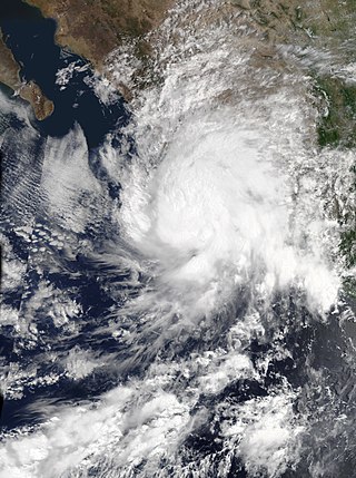
Hurricane Marty was a tropical cyclone that produced heavy rains and flooding in several states in Southwestern and Western Mexico. The twentieth named storm and twelfth hurricane of the annual hurricane season, Marty developed from a tropical wave on September 26, 2015, to the southwest of Acapulco, Guerrero, in Mexico. Initially a tropical depression, the system strengthened into a tropical storm early on the following day. Due to favorable atmospheric conditions, Marty continued to intensify, but wind shear sharply increased as the storm approached a large mid- to upper-level trough. Despite this, the cyclone deepened further, becoming a hurricane on September 28 and peaking with sustained winds of 80 mph (130 km/h) shortly thereafter. Wind shear quickly took its toll on the hurricane, weakening it to a tropical storm early on September 29. About 24 hours later, Marty degenerated into a post-tropical low-pressure area offshore Guerrero. The low further degenerated into a trough later on September 30, and eventually dissipated on October 4.
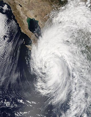
Hurricane Newton was the first tropical cyclone to make landfall on the Baja California Peninsula at hurricane strength since Hurricane Odile in 2014. The fifteenth tropical depression, fifteenth named storm and ninth hurricane of the 2016 Pacific hurricane season, Newton formed from a tropical wave to the south of Mexico on September 4, 2016. Moving northwards through an environment conducive for additional development, Newton rapidly strengthened, reaching hurricane strength on the following day. Newton made landfall on the Baja California Peninsula just below peak strength on the same day. Interaction with the mountainous terrain of the peninsula caused some slight weakening, but Newton remained a hurricane until it entered the Gulf of California, at which time increasing wind shear caused Newton to weaken at a faster pace, and the system made landfall in Sonora late on September 6 as a strong tropical storm. The cyclone continued to rapidly weaken over the rugged terrain of Sonora, and it degenerated into a remnant low just south of the Mexico–United States border on September 7. The remnants of Newton dissipated early on the following day.

The 2018 Pacific hurricane season was one of the most active Pacific hurricane seasons on record, producing the highest accumulated cyclone energy value on record in the basin. The season had the fourth-highest number of named storms – 23, tied with 1982. The season also featured eight landfalls, six of which occurred in Mexico. The season officially began on May 15 in the Eastern Pacific, and on June 1 in the Central Pacific; they both ended on November 30. These dates conventionally delimit the period of each year when most tropical cyclones form in the Pacific basin. However, tropical cyclone formation is possible at any time of the year, as illustrated when the first tropical depression formed on May 10, five days prior to the official start of the season.

Tropical Storm Carlotta was a moderately strong tropical cyclone that caused flooding in several states in southwestern and central Mexico. Carlotta, the third named storm of the 2018 Pacific hurricane season, formed as the result of a breakdown in the Intertropical Convergence Zone. On June 12, a broad area of low pressure developed several hundred miles south of Mexico and strengthened into a tropical storm by June 15. The next day, the system stalled unexpectedly within a favorable environment, which led to more intensification than originally anticipated. Early on June 17, Carlotta reached peak intensity with maximum sustained winds of 65 mph (100 km/h) and a minimum central pressure of 997 mbar while located only 30 mi (50 km) south-southeast of Acapulco. The system then began to interact with land and experience wind shear, which resulted in the storm weakening to tropical depression status later in the day. The system weakened to a remnant low early on June 19 and dissipated several hours later.
The 2021 Pacific hurricane season was a moderately active Pacific hurricane season, with above-average activity in terms of number of named storms, but below-average activity in terms of major hurricanes, as 19 named storms, 8 hurricanes, and 2 major hurricanes formed in all. It also had a near-normal accumulated cyclone energy (ACE). The season officially began on May 15, 2021 in the Eastern Pacific Ocean, and on June 1, 2021, in the Central Pacific in the Northern Hemisphere. The season ended in both regions on November 30, 2021. These dates historically describe the period each year when most tropical cyclogenesis occurs in these regions of the Pacific and are adopted by convention. However, the formation of tropical cyclones is possible at any time of the year, as illustrated by the formation of Tropical Storm Andres on May 9, which was the earliest forming tropical storm on record in the Eastern Pacific. Conversely, 2021 was the second consecutive season in which no tropical cyclones formed in the Central Pacific.

The 2022 Pacific hurricane season was a slightly above average hurricane season in the eastern North Pacific basin, with nineteen named storms, ten hurricanes, and four major hurricanes. Two of the storms crossed into the basin from the Atlantic. In the central North Pacific basin, no tropical cyclones formed. The season officially began on May 15 in the eastern Pacific, and on June 1 in the central; both ended on November 30. These dates historically describe the period each year when most tropical cyclogenesis occurs in these regions of the Pacific and are adopted by convention.

Tropical Storm Vicente was an unusually small tropical cyclone that made landfall as a tropical depression in the Mexican state of Michoacán on October 23, 2018, causing deadly mudslides. The 21st named storm of the 2018 Pacific hurricane season, Vicente originated from a tropical wave that departed from Africa's western coast on October 6. The wave traveled westward across the Atlantic and entered the Eastern Pacific on October 17. The disturbance became better defined over the next couple of days, forming into a tropical depression early on October 19. Located in an environment favorable for further development, the system organized into Tropical Storm Vicente later that day.

Tropical Storm Ileana was a small tropical cyclone that affected western Mexico in early August 2018, causing deadly flooding. The eleventh tropical cyclone and ninth named storm of the 2018 Pacific hurricane season, Ileana originated from a tropical wave that the National Hurricane Center began monitoring on July 26 as the wave left the west coast of Africa. The wave traveled across the Atlantic Ocean with no thunderstorm activity, before crossing into the Eastern Pacific Ocean early on August 4. Rapidly developing, the disturbance organized into a tropical depression on the evening of the same day. Initially, the depression was well-defined, but it soon degraded due to northerly wind shear. Despite the unfavorable conditions, the system began to strengthen on August 5, becoming Tropical Storm Ileana. A day later, on August 6, Ileana began to develop an eyewall structure as it reached its peak intensity with winds of 65 mph (100 km/h) and a pressure of 998 mbar (29.47 inHg). The storm gradually became intertwined with the nearby Hurricane John; over the next day, the circulation of John disrupted Ileana before ultimately absorbing it on August 7.

Tropical Storm Narda was a short-lived tropical storm that remained close to the Pacific coast of Mexico, causing flash flooding and mudslides in southwestern Mexico and the Baja California Peninsula in late September 2019. The fourteenth named storm of the 2019 Pacific hurricane season, Narda developed from a broad area of low pressure that formed off the Central American Pacific coast on September 26. The broad low gradually organized as it moved west-northwestward, and it became Tropical Storm Narda early on September 29 while located off the southern coast of Mexico. The cyclone strengthened slightly before it moved inland near Manzanillo. Narda weakened to a tropical depression after moving inland, but restrengthened into a tropical storm on September 30 as it emerged over the Pacific Ocean just south of the Gulf of California. Narda quickly strengthened, and reached its peak intensity with winds of 50 mph (85 km/h) that day before making a second landfall along the northwestern coast of Mexico. The tropical cyclone weakened rapidly as it moved along the coastline, and it weakened to a tropical depression before dissipating just off the coast of Sonora on October 1.

Tropical Storm Hernan was a short-lived tropical cyclone that brought widespread flooding and destructive mudslides to southwestern Mexico in late August 2020. Hernan was the thirteenth tropical cyclone and eighth named storm of the 2020 Pacific hurricane season. The system developed from a low-pressure area to the southwest of Mexico on August 26, as a low-end tropical storm. Moving generally northward and paralleling the west coast of Mexico, Hernan was hindered by a high wind shear environment and only slightly strengthened. The cyclone achieved its peak intensity around 06:00 UTC on August 27 with maximum sustained winds of 70 km/h (45 mph) and a minimum barometric pressure of 1,001 mbar (29.6 inHg). Passing just offshore of the state of Jalisco, Hernan turned west and degenerated to a remnant low on August 28. The low passed near the southern tip of the Baja California Peninsula later that day and dissipated shortly thereafter.
Tropical Storm Dolores was a strong tropical storm that made landfall in southwestern Mexico in June 2021. The fourth named storm of the 2021 Pacific hurricane season, Dolores developed from a low-pressure area that formed offshore the Mexican state of Oaxaca on June 16, 2021. The low steadily developed organized deep convection and a closed surface circulation, becoming Tropical Depression Four-E around 06:00 UTC June 18. The depression strengthened into a tropical storm nine hours later and was named Dolores. Gradually approaching the southwestern coast of Mexico, Dolores steadily intensified despite its close proximity to land. The storm reached its peak intensity around 15:00 UTC June 19 with maximum sustained winds of 115 km/h (70 mph) and a minimum barometric pressure of 29.2 inHg (989 mbar), just below hurricane strength. Shortly after reaching this intensity, Dolores made landfall just northwest of Punta San Telmo, near the Colima–Michoacán state border. The storm rapidly weakened as it moved inland over Mexico and dissipated early on June 20 over the state of Zacatecas.

Hurricane Nora was a large tropical cyclone that caused significant damage across the Pacific Coast of Mexico in late August 2021. The fourteenth named storm and fifth hurricane of the 2021 Pacific hurricane season, Nora was first monitored by the National Hurricane Center (NHC) as an area of low pressure near the coast of Mexico. On August 24, the low organized into tropical depression, but struggled to develop further due to wind shear in its surrounding environment. The depression eventually intensified into a tropical storm and was named Nora as it tracked to the west-northwest. Nora peaked as a strong Category 1 hurricane with maximum sustained winds of 85 miles per hour (140 km/h) on August 28. The storm then grazed the west coast of Mexico and made landfall two separate times, first in the state of Jalisco, followed by neighboring Nayarit. Nora weakened as it interacted with land, dissipating on August 30 just inland of the Mexican coast.
Hurricane Rick was a Category 2 Pacific hurricane that struck the southwestern coast of Mexico in late October 2021. Rick was the overall seventeenth named system and the eighth hurricane of the 2021 Pacific hurricane season, as well as the fifth named storm and fourth hurricane to make landfall along the Pacific coast of Mexico in 2021.

Tropical Storm Max was the first of four tropical cyclones to make landfall along the Pacific Coast of Mexico in October 2023. The sixteenth tropical depression and thirteenth named storm of the 2023 Pacific hurricane season, Max originated from a trough that developed to the southwest of Central America on October 3, 2023. Showers and thunderstorms associated with the disturbance gradually became better organized over the following days as it moved west-northwestwards to the south of Mexico. The disturbance was designated Potential Tropical Cyclone Sixteen-E on October 7 by the United States National Hurricane Center (NHC), as it had not yet become a tropical cyclone but was threatening the southwestern coast of Mexico. The disturbance developed a more well-defined circulation the following day and developed into a tropical depression; the depression strengthened into a tropical storm late on October 8 and was assigned the name Max. Max progressed northward toward the coast of Mexico and quickly strengthened; the storm made landfall near Puerto Vicente, Guerrero at 18:00 UTC on October 9 just below hurricane strength. Max rapidly weakened as it moved inland across southern Mexico and dissipated the following morning over the region's mountainous terrain.


