Okha is a town and the administrative center of Okhinsky District of Sakhalin Oblast, Russia, located on the east coast of the far north of Sakhalin island, approximately 850 kilometers (530 mi) north of Yuzhno-Sakhalinsk, near the shoreline of the Sea of Okhotsk. Population: 23,008 (2010 Census); 27,963 (2002 Census); 36,104 (1989 Census).

Alexandrovsk-Sakhalinsky is a town in Sakhalin Oblast, Russia, located near the Strait of Tartary on the western shores of Northern Sakhalin at the foot of the Western Sakhalin Mountains. Population: 10,613 (2010 Census); 12,826 (2002 Census); 19,166 (1989 Census); 21,000 (1968).

Yuzhno-Kurilsky District is an administrative district (raion) of Sakhalin Oblast, Russia; one of the seventeen in the oblast. Municipally, it is incorporated as Yuzhno-Kurilsky Urban Okrug. It is located on the southern Kuril Islands southeast of the Island of Sakhalin, comprising the islands of Kunashir, Shikotan, and the Habomai. The area of the district is 1,856.1 square kilometers (716.6 sq mi). Its administrative center is the urban locality of Yuzhno-Kurilsk, located on the Kunashir Island. Population: 9,501 (2010 Census); 9,727 (2002 Census); 13,597 (1989 Census). The population of Yuzhno-Kurilsk accounts for 61.4% of the district's total population.
Shakhtyorsk is a town in Uglegorsky District of Sakhalin Oblast, Russia, located on the western coast of the Sakhalin Island, 376 kilometers (234 mi) northwest of Yuzhno-Sakhalinsk, the administrative center of the oblast. Population: 8,382 (2010 Census); 10,643 (2002 Census); 12,945 (1989 Census).

Aniva is a coastal town and the administrative center of Anivsky District of Sakhalin Oblast, Russia, located on the coast of Aniva Bay in southern Sakhalin Island on the Lyutoga River, 37 kilometers (23 mi) south of Yuzhno-Sakhalinsk. Population: 9,115 (2010 Census); 8,084 (2002 Census); 8,905 (1989 Census).
Makarov is a coastal town and the administrative center of Makarovsky District of Sakhalin Oblast, Russia, located on the eastern coast of the Sakhalin Island, 235 kilometers (146 mi) north of Yuzhno-Sakhalinsk. Population: 6,705 (2010 Census); 7,271 (2002 Census); 11,351 (1989 Census).
Smirnykh is an urban locality and the administrative center of Smirnykhovsky District of Sakhalin Oblast, Russia, located in the central part of the Sakhalin Island. Population: 7,399 (2010 Census); 7,561 (2002 Census); 9,693 (1989 Census).

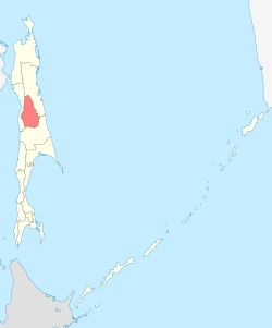
Alexandrovsk-Sakhalinsky District is an administrative district (raion) of Sakhalin Oblast, Russia, one of the seventeen in the oblast. As a municipal division, it is incorporated as Alexandrovsk-Sakhalinsky Urban Okrug. It is located in the west of the oblast. The area of the district is 4,777.4 square kilometers (1,844.6 sq mi). Its administrative center is the town of Alexandrovsk-Sakhalinsky. Population : 2,791 (2010 Census); 4,687 (2002 Census); 8,526 (1989 Census).

Dolinsky District is an administrative district (raion) of Sakhalin Oblast, Russia; one of the seventeen in the oblast. Municipally, it is incorporated as Dolinsky Urban Okrug. It is located in the southeast of the oblast. The area of the district is 2,441.6 square kilometers (942.7 sq mi). Its administrative center is the town of Dolinsk. Population : 13,699 (2010 Census); 15,649 (2002 Census); 22,484 (1989 Census).

Kholmsky District is an administrative district (raion) of Sakhalin Oblast, Russia; one of the seventeen in the oblast. Municipally, it is incorporated as Kholmsky Urban Okrug. It is located in the southwest of the oblast. The area of the district is 2,279 square kilometers (880 sq mi). Its administrative center is the town of Kholmsk. Population : 10,988 (2010 Census); 14,672 (2002 Census); 20,498 (1989 Census).

Korsakovsky District is an administrative district (raion) of Sakhalin Oblast, Russia; one of the seventeen in the oblast. Municipally, it is incorporated as Korsakovsky Urban Okrug. It is located in the southeast of the oblast. The area of the district is 2,623.6 square kilometers (1,013.0 sq mi). Its administrative center is the town of Korsakov. Population : 7,885 (2010 Census); 8,684 (2002 Census); 10,501 (1989 Census).

Kurilsky District is an administrative district (raion) of Sakhalin Oblast, Russia; one of the seventeen in the oblast. Municipally, it is incorporated as Kurilsky Urban Okrug. It is located on the central Kuril Islands southeast of the Island of Sakhalin. The area of the district is 5,145.9 square kilometers (1,986.8 sq mi). Its administrative center is the town of Kurilsk. Population: 7,359 (2010 Census); 7,108 (2002 Census); 10,498 (1989 Census). The population of Kurilsk accounts for 28.1% of the district's total population. The name is sometimes spelled Kurliskiy or Kurliskiye in English.

Nevelsky District is an administrative district (raion) of Sakhalin Oblast, Russia; one of the seventeen in the oblast. Municipally, it is incorporated as Nevelsky Urban Okrug. It is located in the southwest of the oblast. The area of the district is 1,445.4 square kilometers (558.1 sq mi). Its administrative center is the town of Nevelsk. Population : 5,876 (2010 Census); 8,225 (2002 Census); 13,972 (1989 Census).

Nogliksky District is an administrative district (raion) of Sakhalin Oblast, Russia; one of the seventeen in the oblast. Municipally, it is incorporated as Nogliksky Urban Okrug. It is located in the northeast of the Island of Sakhalin. The area of the district is 11,294.8 square kilometers (4,360.9 sq mi). Its administrative center is the urban locality of Nogliki. Population: 12,124 (2010 Census); 13,576 (2002 Census); 16,786 (1989 Census). The population of Nogliki accounts for 84.4% of the district's total population.

Poronaysky District is an administrative district (raion) of Sakhalin Oblast, Russia; one of the seventeen in the oblast. As a municipal division, it is incorporated as Poronaysky Urban Okrug. It is located in the eastern central part of the Island of Sakhalin. The area of the district is 7,280.2 square kilometers (2,810.9 sq mi). Its administrative center is the town of Poronaysk. Population : 21,686 (2010 Census); 10,857 (2002 Census); 17,977 (1989 Census).

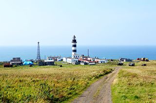
Severo-Kurilsky District is an administrative district (raion) of Sakhalin Oblast, Russia; one of the seventeen in the oblast. Municipally, it is incorporated as Severo-Kurilsky Urban Okrug. It is located on the northern Kuril Islands to the east of the Island of Sakhalin and immediately southwest of the Kamchatka Peninsula. The area of the district is 3,501.2 square kilometers (1,351.8 sq mi). Its administrative center is the town of Severo-Kurilsk. Population: 2,536 (2010 Census); 2,592 (2002 Census); 5,420 (1989 Census). The population of Severo-Kurilsk accounts for 100% of the district's total population.
Smirnykhovsky District is an administrative district (raion) of Sakhalin Oblast, Russia; one of the seventeen in the oblast. Municipally, it is incorporated as Smirnykhovsky Urban Okrug. It is located in the central part of the Island of Sakhalin. The area of the district is 10,457.43 square kilometers (4,037.64 sq mi). Its administrative center is the urban locality of Smirnykh. As of the 2010 Census, the total population of the district was 13,142, with the population of Smirnykh accounting for 56.3% of that number.

Tomarinsky District is an administrative district (raion) of Sakhalin Oblast, Russia; one of the seventeen in the oblast. Municipally, it is incorporated as Tomarinsky Urban Okrug. It is located in the southwest of the Island of Sakhalin. The area of the district is 3,169.3 square kilometers (1,223.7 sq mi). Its administrative center is the town of Tomari. Population: 9,457 (2010 Census); 11,678 (2002 Census); 17,823 (1989 Census). The population of Tomari accounts for 48.0% of the district's total population.
Uglegorsky District is an administrative district (raion) of Sakhalin Oblast, Russia; one of the seventeen in the oblast. Municipally, it is incorporated as Uglegorsky Municipal District. It is located in the western central part of the Island of Sakhalin. The area of the district is 3,965.6 square kilometers (1,531.1 sq mi). Its administrative center is the town of Uglegorsk. Population: 12,156 (2010 Census); 16,804 (2002 Census); 28,022 (1989 Census).
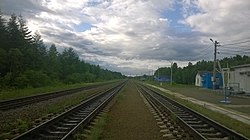
Tymovskoye is an urban locality and the administrative center of Tymovsky District of Sakhalin Oblast, Russia, located in the central part of the Sakhalin Island on the right bank of the Tym River, about 450 kilometers (280 mi) north of Yuzhno-Sakhalinsk. Population: 7,855 (2010 Census); 8,532 (2002 Census); 10,869 (1989 Census).