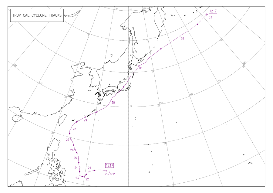
Typhoon Jelawat (2012)

Last updated
Map key
  Tropical depression (≤38 mph, ≤62 km/h)
  Tropical storm (39–73 mph, 63–118 km/h)
  Category 1 (74–95 mph, 119–153 km/h)
  Category 2 (96–110 mph, 154–177 km/h)
  Category 3 (111–129 mph, 178–208 km/h)
  Category 4 (130–156 mph, 209–251 km/h)
  Category 5 (≥157 mph, ≥252 km/h)
  Unknown
Storm type
Disc Plain black.svg Tropical cyclone
Solid black.svg Subtropical cyclone
ArrowUp.svg Extratropical cyclone, remnant low, tropical disturbance, or monsoon depression

Late on September 17, a tropical disturbance formed east of Guam, and the Joint Typhoon Warning Center (JTWC) issued a Tropical Cyclone Formation Alert on the system in the next two days, shortly before the Japan Meteorological Agency (JMA) upgraded the low-pressure area to a tropical depression early on September 20. [2] [3] Several hours later on September 20, the Philippine Atmospheric, Geophysical and Astronomical Services Administration (PAGASA) upgraded the system to a tropical depression named Lawin, before JTWC also upgraded it to a tropical depression due to low vertical wind shear and improved equatorward outflow. [4] [5] Soon, JMA upgraded the system to a tropical storm and named it Jelawat, so did JTWC. [6]

Since September 21, Jelawat moved southwestwards slowly by tracking along the southwestern extension of the subtropical ridge anchoring east of Japan. Despite favourable conditions, the storm has struggled to improve its organization. [7] When Jelawat was drifting westwards by a weak steering environment on September 22, it intensified into a severe tropical storm for excellent equatorward outflow because of speedy divergence to the south, and a tropical upper tropospheric trough cell northeast of the system started to improved its poleward outflow. [8] Later, the system began to form an eyewall with excellent equatorward outflow and good poleward outflow. [9]

Typhoon Jelawat approaching Okinawa on September 27 Jelawat Sept 27 2012 0505Z.jpg
Typhoon Jelawat approaching Okinawa on September 27
28 September, Taiwan Central Weather Bureau's Maritime Typhoon Warning Jie La Hua Tai Feng Hai Shang Jing Bao .jpg
28 September, Taiwan Central Weather Bureau's Maritime Typhoon Warning

Based on the improved organization, both JMA and JTWC upgraded Jelawat to a typhoon early on September 23, before the system began to drift northwards due to a complex steering environment resulting from a trough over East Asia and a tropical depression (later becoming Severe Tropical Storm Ewiniar) in the east. [10] [11] Eighteen hours later, JTWC upgraded Jelawat to a super typhoon after the system underwent explosive intensification, becoming a well-developed system with a 10-nautical-mile (19 km; 12 mi) eye and strong spiral banding. [12]

Late on September 24, by low vertical wind shear and favourable outflow aloft across all quadrants, Typhoon Jelawat attained its peak intensity by the 10-minute maximum sustained winds reaching 110 knots (205 km/h, 125 mph) and the atmospheric pressure decreasing to 905 hPa (26.72 inHg). The typhoon also reached category 5 strength on the Saffir–Simpson hurricane wind scale, with a solid band of deep convection surrounding a 20-nautical-mile (37 km; 23 mi) eye. [13] Tracking northwestwards since September 25, Typhoon Jelawat entered an eyewall replacement cycle, and the process ended with a 25-nautical-mile (46 km; 29 mi) eye on the next day. [14]

Having maintained peak intensity for nearly two days because of excellent radial outflow enhanced by a poleward stream, Jelawat weakened slightly from late September 26 to early September 27, yet the diameter of that larger eye became 40 nautical miles (74 km; 46 mi). [15] Later, the system tracked northward, for a trough over East China was eroding the subtropical ridge. [16] When approaching Okinawa, Jelawat began to move northeastwards by tracking along the western edge of the subtropical ridge on September 28, and JTWC downgraded the system to a typhoon for a slight elongation in the overall shape. [17] At the same time, Jelawat weakened slightly due to another eyewall replacement cycle, but radial outflow and improving poleward outflow into a deep mid-latitude shortwave trough helped the typhoon maintain intensity. [18]

With a shrunken 7-nautical-mile (13 km; 8.1 mi) pinhole eye, Typhoon Jelawat passed through the west coast of Okinawa Island early on September 29, when the estimated 10-minute maximum sustained winds were at 90 knots (165 km/h, 105 mph). [19] Equatorward outflow has significantly hindered, as Jelawat started to gradually weaken; however, poleward outflow remained well-established and was linked to a deep mid-latitude trough directly to the north of the system. [20] Then, the typhoon accelerated northeastwards and moved into an area of strong southwesterly vertical wind shear, but jet-induced poleward outflow kept the system from rapid decaying. [21]

Since September 30, Jelawat was fully embedded in baroclinic zone and began extratropical transition, as the convective banding was unraveling. [22] At 06Z, JTWC downgraded Jelawat to a tropical storm, for deep convection was sheared to the north. [23] The system made landfall over Aichi Prefecture in Japan at 10Z, when the estimated 10-minute maximum sustained winds were at 70 knots (130 km/h, 80 mph). Eight hours later, JMA downgraded Jelawat to a severe tropical storm when it was located in Iwate Prefecture, and JTWC issued the final warning on the system simultaneously. [24] On October 1, JMA downgraded Jelawat to a tropical storm, shortly before becoming extratropical east of Kuril Islands. The extratropical cyclone strengthened and regained storm-force status on October 2, before the system crossed the International Date Line and began to weakened on October 3. [25] [26]

Preparations and impact

Typhoon Jelawat nearing landfall over Japan on September 29. A Karman vortex street can also be seen on the left of frame, off the Jeju do Jelawat 2012-09-29 2201Z.png
Typhoon Jelawat nearing landfall over Japan on September 29. A Kármán vortex street can also be seen on the left of frame, off the Jeju do

On September 29, 2012, Jelawat passed through Okinawa Prefecture. According to the Japan Meteorological Agency, the maximum gust produced by Typhoon Jelawat was at 62.6 m/s (225 km/h) in Miyagi Island of Uruma, Okinawa. [27] The maximum sustained winds were at 41.1 m/s (148 km/h) in Naha, ranked the tenth-strongest in that county seat and the largest city of Okinawa Prefecture on record. The storm also produced the maximum gust at 61.2 m/s (220 km/h) in Naha, ranked the third-strongest in that city on record. [28] [29]

Reports suggested that some 65 people were injured in the storm while 331,000 people remained without electricity. Strong winds flipped cars and uprooted trees. A four-ton truck was reportedly turned upside down by the winds causing a major roadblock in Naha. Flights and ferries connecting Okinawa to the rest of Japan were all cancelled. [30] Jelawat was known locally as Typhoon Seventeen. Up to 4,200 households in the regions of Higashi and Nago was asked to evacuate immediately. [31] Across Okinawa Prefecture, damage to agriculture amounted to ¥1.7 billion (US$21.6 million). [32]

In Japan, preparations for the storm started early on September 30. The storm was located nearly 220 km (140 mi) south of southwestern prefecture of Kochi, when officials warned the locals of strong wind, torrential rain, landslides and possible flash flooding. By then, Jelawat had already injured 96 people. [33] In Tokyo, several trains were cancelled and up to 300 flights to the city's Narita International Airport were cancelled. Up to 20 inches (510 mm) of rain was expected. [34] By October 1, one person had been killed and 140 other people were reportedly injured. Authorities in the central city of Nagoya have made it compulsory for 57,000 people to leave their homes in the wake of rising river levels in the city, which can cause significant flooding. [35] Among the dead was a 29-year-old man who was swept away by high waves while the typhoon was passing Okinawa. In Mie Prefecture, another 2,000 people were asked to evacuate. Waves as high as 10 metres (33 ft) were advised of. Meanwhile, in Tokyo, up to 500 millimetres (20 in) of rain was expected over the next 24 hours. Several other trains were cancelled and the total number of flights cancelled went up to 500. [36]

By the night of October 1, a 56-year-old man who had been missing since the past 24 hours was confirmed dead, after he had drowned. Local news agency, NHK, reported that over 181 people were injured in the typhoon. [37] A further 11,000 were told to evacuate in the city of Ishinomaki in the country's northeast, Jiji Press reported. The local Meteorological agency predicted rainfall of up to 400 millimetres (16 in) in some areas in the 24 hours. [38]

Total agricultural damage across the nation reached ¥8.935 billion (US$115 million). [39]

See also

Related Research Articles

<span class="mw-page-title-main">2012 Pacific typhoon season</span> Typhoon season in the Western Pacific Ocean

The 2012 Pacific typhoon season was a slightly above average season that produced 25 named storms, fourteen typhoons, and four intense typhoons. It was a destructive and the second consecutive year to be the deadliest season. It was an event in the annual cycle of tropical cyclone formation, in which tropical cyclones form in the western Pacific Ocean. The season ran throughout 2012, though most tropical cyclones typically develop between May and October. The season's first named storm, Pakhar, developed on March 28, while the season's last named storm, Wukong, dissipated on December 29. The season's first typhoon, Guchol, reached typhoon status on June 15, and became the first super typhoon of the year on June 17.

<span class="mw-page-title-main">2015 Pacific typhoon season</span> Typhoon season in the Western Pacific Ocean

The 2015 Pacific typhoon season was a slightly above average season that produced twenty-seven tropical storms, eighteen typhoons, and nine super typhoons. The season ran throughout 2015, though most tropical cyclones typically develop between May and November. The season's first named storm, Mekkhala, developed on January 15, while the season's last named storm, Melor, dissipated on December 17. The season saw at least one named tropical system forming in each of every month, the first time since 1965. Similar to the previous season, this season saw a high number of super typhoons. Accumulated cyclone energy (ACE) during 2015 was extremely high, the third highest since 1970, and the 2015 ACE has been attributed in part to anthropogenic warming.

<span class="mw-page-title-main">2016 Pacific typhoon season</span> Typhoon season in the Western Pacific Ocean

The 2016 Pacific typhoon season is considered to have been the fourth-latest start for a Pacific typhoon season since reliable records began. It was an average season, with a total of 26 named storms, 13 typhoons, and six super typhoons. The season ran throughout 2016, though typically most tropical cyclones develop between May and October. The season's first named storm, Nepartak, developed on July 3, while the season's last named storm, Nock-ten, dissipated on December 28.

<span class="mw-page-title-main">2018 Pacific typhoon season</span> Typhoon season in the Western Pacific Ocean

The 2018 Pacific typhoon season was at the time, the costliest Pacific typhoon season on record, until the record was beaten by the following year. The season was well above-average, producing twenty-nine storms, thirteen typhoons, seven super typhoons and six Category 5 tropical cyclones. The season ran throughout 2018, though most tropical cyclones typically develop between May and October. The season's first named storm, Bolaven, developed on January 3, while the season's last named storm, Man-yi, dissipated on November 28. The season's first typhoon, Jelawat, reached typhoon status on March 29, and became the first super typhoon of the year on the next day.

<span class="mw-page-title-main">Typhoon Tembin (2012)</span> Pacific typhoon in 2012

Typhoon Tembin, known in the Philippines as Typhoon Igme, was an intense tropical cyclone in the Western Pacific Ocean that had an unusual trajectory, approaching Taiwan twice. Tembin, which means balancing scale or Libra in Japanese, was the eighth typhoon and the fourteenth named storm of the 2012 Pacific typhoon season. After making landfall over the southern tip of Taiwan late on August 23, Tembin weakened but regained strength in the South China Sea, looping before making a second landfall on southern Taiwan as a tropical storm on August 27; however, the system did not restrengthen in the East China Sea, and made landfall over South Korea on August 30 before becoming extratropical.

<span class="mw-page-title-main">Typhoon Sanba</span> Pacific typhoon in 2012

Typhoon Sanba, known in the Philippines as Super Typhoon Karen, was the strongest tropical cyclone worldwide in 2012. The sixteenth named storm and tenth typhoon of the annual typhoon season, Sanba formed as a tropical depression east of the Philippines on September 10. The storm gradually intensified as it moved generally northward in an area favorable for tropical development. The system was soon upgraded to a tropical storm less than a day after formation and subsequently further to a typhoon on September 12. Later that day, Sanba entered a phase of rapid intensification, and quickly strengthened. On September 13, the system attained its peak intensity with maximum sustained winds of 125 mph (205 km/h), and a barometric pressure of 900 mbar, becoming the strongest typhoon in the Western Pacific Ocean since Megi in 2010. Accelerating towards more northerly latitudes, a period of gradual weakening ensued afterwards as its eye expanded. It made landfall on South Korea late on September 17 as a typhoon before transitioning into an extratropical cyclone the following day. Sanba's remnants tracked into the Primorsky Krai region of eastern Russia before they were last noted on September 19.

<span class="mw-page-title-main">Typhoon Lekima (2013)</span> Pacific typhoon in 2013

Typhoon Lekima was the second most intense tropical cyclone worldwide in 2013, as well as the twenty-ninth named storm and the eleventh typhoon of the annual typhoon season. It developed into a tropical storm late on October 20. After Lekima intensified into a typhoon and underwent rapid deepening in a very favorable environment on October 22, the system reached peak intensity on the following day. Maintaining its strength for over one day, Lekima began to weaken on October 24, as stronger vertical wind shear and mid-latitude westerlies began to make the typhoon significantly decay. On October 26, Lekima transitioned into an extratropical cyclone east of Japan.

<span class="mw-page-title-main">Typhoon Francisco (2013)</span> Pacific typhoon in 2013

Typhoon Francisco, known in the Philippines as Typhoon Urduja, was a powerful typhoon that strengthened to the equivalent of a Category 5 on the Saffir-Simpson scale, according to the Joint Typhoon Warning Center. The 25th named storm and the 10th typhoon of the 2013 Pacific typhoon season, Francisco formed on October 16 east of Guam from a pre-existing area of convection. With favorable conditions, it quickly intensified into a tropical storm before passing south of Guam. After stalling to the southwest of the island, Francisco turned to the northwest into an environment of warm waters and low wind shear, becoming a typhoon. The JTWC upgraded it to super typhoon status on October 18, while the Japan Meteorological Agency (JMA) estimated peak 10-minute sustained winds of 195 km/h (121 mph). Gradual weakening ensued, and after the typhoon turned to the northeast, Francisco deteriorated into a tropical storm on October 24. Passing southeast of Okinawa and mainland Japan, the storm accelerated and became extratropical on October 26, dissipating later that day.

<span class="mw-page-title-main">Timeline of the 2012 Pacific typhoon season</span>

This timeline documents all of the events of the 2012 Pacific typhoon season, the period that tropical cyclones formed in the Western Pacific Ocean during 2012. Most of these tropical cyclones formed between May and November 2012. The scope of this article is limited to the Pacific Ocean, north of the equator between 100°E and the International Date Line. Tropical storms that form in the entire Western Pacific basin are assigned a name by the Japan Meteorological Agency (JMA). Tropical depressions that form in this basin are given a number with a "W" suffix by the United States' Joint Typhoon Warning Center (JTWC). In addition, the Philippine Atmospheric, Geophysical and Astronomical Services Administration (PAGASA) assigns names to tropical cyclones that enter or form in the Philippine area of responsibility. These names, however, are not in common use outside of the Philippines.

<span class="mw-page-title-main">Typhoon Neoguri (2014)</span> Pacific typhoon in 2014

Typhoon Neoguri, known in the Philippines as Typhoon Florita, was a large and powerful tropical cyclone which struck Japan in 2014. The eighth named storm and the second typhoon of the annual typhoon season, Neoguri developed into a tropical storm on July 3 and then a typhoon on July 4. It rapidly deepened on July 5, reaching peak intensity late on July 6. Neoguri began to decay on July 7 and passed through Okinawa on July 8 and then making landfall over Kyushu as a severe tropical storm late on July 9. After Neoguri passed through the southern coast of Honshū on July 10, it became extratropical on July 11.

<span class="mw-page-title-main">Typhoon Phanfone (2014)</span> Pacific typhoon in 2014

Typhoon Phanfone, known in the Philippines as Typhoon Neneng, was a powerful tropical cyclone which affected Japan in early October 2014. It was the eighteenth named storm and the eighth typhoon of the 2014 Pacific typhoon season.

<span class="mw-page-title-main">Typhoon Vongfong (2014)</span> Pacific typhoon in 2014

Typhoon Vongfong, known in the Philippines as Super Typhoon Ompong, was the most intense tropical cyclone worldwide in 2014, and struck Japan as a large tropical system. It also indirectly affected the Philippines and Taiwan. Vongfong was the nineteenth named storm and the ninth typhoon of the 2014 Pacific typhoon season. Estimates assess damage from Vongfong to have been over US$160 million, mainly for striking mainland Japan. At least 9 people were killed along the path of the typhoon in those countries.

<span class="mw-page-title-main">Typhoon Hagupit (2014)</span> Pacific typhoon in 2014

Typhoon Hagupit, known in the Philippines as Super Typhoon Ruby, was the second most intense tropical cyclone in 2014. Hagupit particularly impacted the Philippines in early December while gradually weakening, killing 18 people and causing $114 million of damage in the country. Prior to making landfall, Hagupit was considered the worst threat to the Philippines in 2014, but it was significantly smaller than 2013's Typhoon Haiyan.

<span class="mw-page-title-main">Typhoon Dujuan (2015)</span> Pacific typhoon in 2015

Typhoon Dujuan, known in the Philippines as Typhoon Jenny, was the second most intense tropical cyclone of the Northwest Pacific Ocean in 2015 in terms of ten-minute maximum sustained winds, tied with Noul. The twenty-first named storm and the thirteenth typhoon of the 2015 Pacific typhoon season, Dujuan brought extremely powerful winds throughout the Yaeyama Islands and Taiwan in late September, causing 3 deaths in Taiwan. The typhoon also caused over ¥2.5 billion (US$392.9 million) damage in East China.

<span class="mw-page-title-main">Typhoon Mindulle (2016)</span> Pacific typhoon in 2016

Typhoon Mindulle was a strong tropical cyclone which affected Japan in late August 2016. It was the ninth named storm and the second typhoon of the annual typhoon season in 2016.

<span class="mw-page-title-main">Typhoon Malakas (2016)</span> Pacific typhoon in 2016

Typhoon Malakas, known in the Philippines as Typhoon Gener, was a powerful tropical cyclone which affected Taiwan and Japan in mid September 2016. It was the sixteenth named storm and the sixth typhoon of the annual typhoon season in 2016.

<span class="mw-page-title-main">Typhoon Chaba (2016)</span> Pacific typhoon in 2016

Typhoon Chaba, known in the Philippines as Typhoon Igme, was the fourth most intense tropical cyclone in 2016 and the strongest tropical cyclone to make landfall in South Korea since Sanba in 2012. Chaba also caused 7 deaths in the country. Typhoon Chaba was the eighteenth named storm and the eighth typhoon of the 2016 Pacific typhoon season.

<span class="mw-page-title-main">Typhoon Noru (2017)</span> Pacific typhoon in 2017

Typhoon Noru was the second-longest-lasting tropical cyclone of the Northwest Pacific Ocean on record—behind only 1986's Wayne and tied with 1972's Rita—and the second-most-intense tropical cyclone of the basin in 2017, tied with Talim. Forming as the fifth named storm of the annual typhoon season on July 20, Noru further intensified into the first typhoon of the year on July 23. However, Noru began to interact with nearby Tropical Storm Kulap on July 24, executing a counterclockwise loop southeast of Japan. Weakening to a severe tropical storm on July 28, Noru began to restrengthen as it turned sharply to the west on July 30. Amid favorable conditions, Noru rapidly intensified into the season's first super typhoon, and reached peak intensity with annular characteristics on July 31. In early August, Noru underwent a gradual weakening trend while curving northwestwards and then northwards. After stalling off the Satsunan Islands weakening to a severe tropical storm again on August 5, the system began to accelerate northeastwards towards the Kansai region of Japan, making landfall in Wakayama Prefecture on August 7. Noru became extratropical over the Sea of Japan on August 8, and dissipated one day later.

<span class="mw-page-title-main">Typhoon Lan (2017)</span> Pacific typhoon in 2017

Typhoon Lan, known in the Philippines as Super Typhoon Paolo, was the third-most intense tropical cyclone worldwide in 2017, behind only hurricanes Irma and Maria in the Atlantic. A very large storm, Lan was the twenty-first tropical storm and ninth typhoon of the annual typhoon season. It originated from a tropical disturbance that the United States Naval Research Laboratory had begun tracking near Chuuk on October 11. Slowly consolidating, it developed into a tropical storm on October 15, and intensified into a typhoon on October 17. It expanded in size and turned northward on October 18, although the typhoon struggled to intensify for two days. On October 20, Lan grew into a very large typhoon and rapidly intensified, due to favorable conditions, with a large well-defined eye, reaching peak intensity as a "super typhoon" with 1-minute sustained winds of 249 km/h (155 mph) – a high-end Category 4-equivalent storm – late on the same day. Afterward, encroaching dry air and shear caused the cyclone to begin weakening and turn extratropical, before it struck Japan on October 23 as a weaker typhoon. Later that day, it became fully extratropical before it was absorbed by a larger storm shortly afterward.

<span class="mw-page-title-main">Typhoon Jelawat (2018)</span> Pacific typhoon in 2018

Typhoon Jelawat, known in the Philippines as Tropical Storm Caloy, was a powerful typhoon that affected the Caroline Islands on March 2018. The third tropical storm and the first typhoon of the 2018 Pacific typhoon season, Jelawat originated as a tropical disturbance that struck the Federated States of Micronesia before organizing into a tropical depression on March 24. It further intensified into a tropical storm on the following day, according to the Japan Meteorological Agency, receiving the name Jelawat. Drifting northward, the storm remained unorganized while staying east of the Philippines, though environmental conditions were becoming more favorable as the storm moved along its path. On March 29, Jelawat took an unexpected sharp turn east as it intensified into a typhoon. Upon shifting northeast, Jelawat rapidly intensified on March 30 due to low vertical wind shear and substantial outflow, peaking as a Category 4-equivalent super typhoon. Shortly afterward, the storm began to weaken as wind shear sharply increased, falling below typhoon strength on March 31. The storm transitioned into a subtropical cyclone on April 1, before dissipating on that same day.

References

  1. 平成24年台風第17号による被害状況等について(第2報) (PDF) (in Japanese). Ministry of Land, Infrastructure, Transport and Tourism. Retrieved 26 April 2013.
  2. "TROPICAL CYCLONE FORMATION ALERT". Joint Typhoon Warning Center. Archived from the original on 21 September 2012. Retrieved 22 April 2013.
  3. "Marine Weather Warning for GMDSS Metarea XI 2012-09-20T00:00:00Z". WIS Portal – GISC Tokyo. Japan Meteorological Agency. Retrieved 22 April 2013.
  4. "Tropical Cyclone Alert: Tropical Depression "LAWIN"". Philippine Atmospheric, Geophysical and Astronomical Services Administration. Archived from the original on 20 September 2012. Retrieved 22 April 2013.
  5. "PROGNOSTIC REASONING FOR TROPICAL DEPRESSION 18W (EIGHTEEN) WARNING NR 01". Joint Typhoon Warning Center. Archived from the original on 21 September 2012. Retrieved 22 April 2013.
  6. "TROPICAL STORM 18W (JELAWAT) WARNING NR 002". Joint Typhoon Warning Center. Archived from the original on 21 September 2012. Retrieved 22 April 2013.
  7. "PROGNOSTIC REASONING FOR TROPICAL STORM 18W (JELAWAT) WARNING NR 04". Joint Typhoon Warning Center. Archived from the original on 26 September 2012. Retrieved 22 April 2013.
  8. "PROGNOSTIC REASONING FOR TROPICAL STORM 18W (JELAWAT) WARNING NR 07". Joint Typhoon Warning Center. Archived from the original on 26 September 2012. Retrieved 22 April 2013.
  9. "PROGNOSTIC REASONING FOR TROPICAL STORM 18W (JELAWAT) WARNING NR 10". Joint Typhoon Warning Center. Archived from the original on 26 September 2012. Retrieved 22 April 2013.
  10. "TYPHOON 18W (JELAWAT) WARNING NR 011". Joint Typhoon Warning Center. Archived from the original on 30 September 2012. Retrieved 22 April 2013.
  11. "PROGNOSTIC REASONING FOR TYPHOON 18W (JELAWAT) WARNING NR 12". Joint Typhoon Warning Center. Archived from the original on 26 September 2012. Retrieved 22 April 2013.
  12. "SUPER TYPHOON 18W (JELAWAT) WARNING NR 014". Joint Typhoon Warning Center. Archived from the original on 30 September 2012. Retrieved 22 April 2013.
  13. "PROGNOSTIC REASONING FOR SUPER TYPHOON 18W (JELAWAT) WARNING NR 18". Joint Typhoon Warning Center. Archived from the original on 26 September 2012. Retrieved 22 April 2013.
  14. "PROGNOSTIC REASONING FOR SUPER TYPHOON 18W (JELAWAT) WARNING NR 25". Joint Typhoon Warning Center. Archived from the original on 26 September 2012. Retrieved 25 April 2013.
  15. "PROGNOSTIC REASONING FOR SUPER TYPHOON 18W (JELAWAT) WARNING NR 27". Joint Typhoon Warning Center. Archived from the original on 29 September 2012. Retrieved 25 April 2013.
  16. "PROGNOSTIC REASONING FOR SUPER TYPHOON 18W (JELAWAT) WARNING NR 29". Joint Typhoon Warning Center. Archived from the original on 29 September 2012. Retrieved 25 April 2013.
  17. "PROGNOSTIC REASONING FOR TYPHOON 18W (JELAWAT) WARNING NR 31". Joint Typhoon Warning Center. Archived from the original on 29 September 2012. Retrieved 25 April 2013.
  18. "PROGNOSTIC REASONING FOR TYPHOON 18W (JELAWAT) WARNING NR 32". Joint Typhoon Warning Center. Archived from the original on 29 September 2012. Retrieved 25 April 2013.
  19. "PROGNOSTIC REASONING FOR TYPHOON 18W (JELAWAT) WARNING NR 35". Joint Typhoon Warning Center. Archived from the original on 29 September 2012. Retrieved 25 April 2013.
  20. "PROGNOSTIC REASONING FOR TYPHOON 18W (JELAWAT) WARNING NR 36". Joint Typhoon Warning Center. Archived from the original on 30 September 2012. Retrieved 25 April 2013.
  21. "PROGNOSTIC REASONING FOR TYPHOON 18W (JELAWAT) WARNING NR 38". Joint Typhoon Warning Center. Archived from the original on 30 September 2012. Retrieved 25 April 2013.
  22. "PROGNOSTIC REASONING FOR TYPHOON 18W (JELAWAT) WARNING NR 39". Joint Typhoon Warning Center. Archived from the original on 30 September 2012. Retrieved 25 April 2013.
  23. "PROGNOSTIC REASONING FOR TROPICAL STORM 18W (JELAWAT) WARNING NR 40". Joint Typhoon Warning Center. Archived from the original on 1 October 2012. Retrieved 25 April 2013.
  24. "TROPICAL STORM 18W (JELAWAT) WARNING NR 042". Joint Typhoon Warning Center. Archived from the original on 1 October 2012. Retrieved 25 April 2013.
  25. "Marine Weather Warning for GMDSS Metarea XI 2012-10-02T00:00:00Z". WIS Portal – GISC Tokyo. Japan Meteorological Agency. Retrieved 25 April 2013.
  26. "Marine Weather Warning for GMDSS Metarea XI 2012-10-03T00:00:00Z". WIS Portal – GISC Tokyo. Japan Meteorological Agency. Retrieved 25 April 2013.
  27. 沖縄気象台. 台風第 17 号接近時に観測された地域気象観測所「宮城島」の風速につ いて (PDF) (in Japanese). Japan Meteorological Agency. Retrieved 26 April 2013.
  28. 沖縄気象台. 平成24年台風第17号について (PDF) (in Japanese). Japan Meteorological Agency. Retrieved 26 April 2013.
  29. 観測史上1~10位の値( 年間を通じての値). 那覇 (沖縄県) (in Japanese). Japan Meteorological Agency. Retrieved 26 April 2013.
  30. "Typhoon Jelawat injures 65 along Japanese coast (update)". Digital Journal. Retrieved 2 October 2012.
  31. "Powerful typhoon hits Okinawa, heads for Kanto". Daily Yomiuri Online. Retrieved 2 October 2012.
  32. "1.7 billion yen 88 million agricultural damage: Typhoon No. 17" (in Japanese). Okinawa Times. October 2, 2012. Archived from the original on October 5, 2012. Retrieved October 4, 2012.
  33. "Typhoon approaching Japan's main islands". China Daily. Retrieved 2 October 2012.
  34. "Powerful typhoon homes in on Tokyo". HeraldNet. 29 September 2012. Retrieved 2 October 2012.
  35. "Japan's capital braces for powerful typhoon". Radio Australia. Retrieved 2 October 2012.
  36. "Tropical Storm Churns Through Central Japan". Sky News HD. Retrieved 2 October 2012.
  37. "Powerful typhoon kills two in Japan". Brisbane Times. October 2012. Retrieved 2 October 2012.
  38. "Mass evacuations as typhoon hits Japan". MWC news. Retrieved 2 October 2012.
  39. 平成24年台風第17号の被害状況等について. 農林水産省 (in Japanese). December 10, 2013. Archived from the original on December 14, 2013. Retrieved December 15, 2013.
Typhoon Jelawat (Lawin)
Jelawat Sept 25 2012 0210Z.jpg
Typhoon Jelawat at peak intensity on September 25