Typhoon Maysak (2020)

Last updated
Map key
  Tropical depression (≤38 mph, ≤62 km/h)
  Tropical storm (39–73 mph, 63–118 km/h)
  Category 1 (74–95 mph, 119–153 km/h)
  Category 2 (96–110 mph, 154–177 km/h)
  Category 3 (111–129 mph, 178–208 km/h)
  Category 4 (130–156 mph, 209–251 km/h)
  Category 5 (≥157 mph, ≥252 km/h)
  Unknown
Storm type
Disc Plain black.svg Tropical cyclone
Solid black.svg Subtropical cyclone
ArrowUp.svg Extratropical cyclone, remnant low, tropical disturbance, or monsoon depression

Following the impacts of Typhoon Bavi on the Korean peninsula in August 2020, the Korea Meteorological Administration (KMA) began to anticipate the development of a new tropical cyclone with the potential to be stronger and more damaging for the region than Bavi. [1] The KMA assessed a high probability of the storm's development, but noted that its future impacts were uncertain; [2] the Joint Typhoon Warning Center (JTWC) also determined that there was a high likelihood of a "significant tropical cyclone" developing. [3] Maysak's precursor disturbance was an area of low pressure over the western Pacific east of the Philippines. [4] At 06:00  UTC on August 27, the Japan Meteorological Agency determined that a nearly stationary tropical depression had formed near 15°N, 132°E. [5] The JTWC issued a Tropical Cyclone Formation Alert for the system around the same time. [6] The newly formed system was located in an environment conducive to storm development, including warm sea surface temperatures and low vertical wind shear. [7] Clusters of atmospheric convection emerged around the storm's center, comprising formative rainbands wrapping into the developing circulation. [8] [9] Early on August 28, the Philippine Atmospheric, Geophysical and Astronomical Services Administration (PAGASA) assessed the system as a tropical depression with the local name Julian. [10] At 06:00 UTC, the JMA assessed the tropical depression to have strengthened into a tropical storm, assigning it with the name Maysak. By this time, outflow had become established and curvature of the Maysak's rainbands became apparent on satellite imagery. [11] The storm's cloud tops cooled substantially, indicative of further consolidation of its circulation. [12] Maysak became a severe tropical storm twelve hours later. [13] Maysak became a typhoon by 12:00 UTC on August 29 according to the JMA after developing an eye. The storm also began to move towards the north in response to a nearby subtropical ridge. [14] [15] [16]

On August 30, Maysak's structure became indicative of an impending phase of rapid intensification according to the JTWC. [17] The typhoon developed a central dense overcast that day with an eye embedded within. [18] An approaching trough over eastern China and western Japan caused Maysak to accelerate towards the north as it continued to traverse energetic ocean waters. [19] The typhoon's eye became symmetric and spanned 55 km (34 mi) across. [20] By 21:00 UTC, the eye had contracted to a diameter of 19 km (12 mi). Around that time, the JTWC assessed the typhoon as having one-minute sustained winds of 215 km/h (134 mph). [21] At 00:00 UTC on September 1, the JMA determined that Maysak had ten-minute maximum sustained winds of 110 mph (180 km/h) with gusts of up to 250 km/h (160 mph). The associated barometric pressure was estimated at 935  hPa (mbar; 27.61  inHg). [22] [23] Maysak held this intensity as it began to move into a less conducive environment for storm development within the East China Sea. [24] Soon, Maysak began to weaken steadily as it passed the East China Sea, slowing back down to a Category 3 storm. The storm then made landfall near Busan, South Korea at 02:20 KST on September 3 (17:20 UTC on September 2), with 10-minute maximum sustained winds at 155 km/h (96 mph) and the central pressure at 950 hPa [25] equivalent into a Category 2 typhoon. After that, it crossed the Sea of Japan and hitting North Korea into Jilin in northeast China. Soon after, Typhoon Maysak transitioned into an extratropical low in northeast China. [26]

Preparations and impact

The storm affected the eastern parts of South Korea, North Korea, China, and Russia, along with the Ryukyu Islands, causing at least 32 deaths and damage to more than 9,200 houses. Total combined economic losses were anticipated to surpass US$100 million. [27]

Japan

The JMA urged residents of Okinawa to evacuate in anticipation of a potentially "major disaster" from Maysak; 560 people ultimately evacuated. [28] [29] The agency also warned of the possibility of tornadoes in the region. [30] Schools, stores, and public offices throughout the prefecture closed. As many as 266 flights linking to Okinawa were cancelled, affecting roughly 9,200 travelers. [28] [31] [32] The Naha Airport closed its passenger terminal in advance of Maysak. [32] The cancellation of flights at Okinawa also led to the cancellation of 10 percent of departures from Haneda Airport. [33] Kadena Air Force Base was placed on Tropical Cyclone Conditions of Readiness level 1 (TCCOR 1), denoting the onset of destructive winds. Okinawa was buffeted by wind gusts generally ranging between 100 and 130 km/h (62 and 81 mph). A peak gust of 163 km/h (101 mph) was measured in Nanjō. [34] Wind gusts reached 195 km/h (121 mph) at Kumejima Airport. [35] Power outages affected 1,580 electricity customers in Nago, Naha, and Nakijin. [29] Agricultural damage across the prefecture were at JP¥236.4 million (US$2.23 million). [36]

Officials in Kyushu warned of strong winds and mudslides. Maysak caused powerful winds and drenching rainfall to the Ryukyu Islands of Japan as it passed through, also causing some power outages. [37] Agricultural damage in Saga Prefecture were calculated to be JP¥609 million (US$5.74 million). [38]

Gulf Livestock 1 shipwreck

On 2 September 2020, Panamanian-flagged cargo ship Gulf Livestock 1 with 43 crew members, including 39 seamen from the Philippines, two from New Zealand and two from Australia, and thousands of cattle onboard was reported missing in the East China Sea. The Japan Coast Guard said it has found one person drifting in rough waters in a lifejacket. A distress signal was sent from the ship shortly before disappearing. [39] The body of a person was found two days later. [40] By October, the remaining 41 seamen were declared dead. [27]

South Korea

In South Korea, 2,200 people were evacuated into shelters in preparation for Maysak. Maysak resulted in two deaths, [41] caused over 120,000 power outages, and damaged over 5,100 hectares of farmland as well as a further 800 structures. [42] South Korea's Ministry of Interior and Safety cited notable damage to nearly 2,000 buildings. [27]

North Korea

Maysak brought heavy rainfall to eastern North Korea peaking at 15.157 inches (385.0 mm) in Wonsan. Photos showed streets and buildings being flooded in the area. [43] North Korea's state television network once more broadcast live storm reports overnight from State Hydro-Meteorological Administration and outside as they had done with Typhoon Bavi just a week previous to Maysak. [44] [45]

China

The extratropical remnants of Maysak moved into Jilin, bringing heavy rains to the province. Damage was amounted to be CN¥6.18 million (US$903 thousand). [46]

Russia

Maysak struck the Primorsky Krai as an extratropical cyclone, which killed three people and led to 200 million (US$2.65 million) in losses. [47]

See also

Related Research Articles

<span class="mw-page-title-main">Tropical Storm Higos (2008)</span> Pacific tropical storm in 2008

Tropical Storm Higos, known in the Philippines as Tropical Storm Pablo, was a tropical storm during the 2008 Pacific typhoon season. The name "Higos" is the Chamorro word for fig.

<span class="mw-page-title-main">2015 Pacific typhoon season</span> Typhoon season in the Western Pacific Ocean

The 2015 Pacific typhoon season was a slightly above average season that produced twenty-seven tropical storms, eighteen typhoons, and nine super typhoons. The season ran throughout 2015, though most tropical cyclones typically develop between May and November. The season's first named storm, Mekkhala, developed on January 15, while the season's last named storm, Melor, dissipated on December 17. The season saw at least one named tropical system forming in each of every month, the first time since 1965. Similar to the previous season, this season saw a high number of super typhoons. Accumulated cyclone energy (ACE) during 2015 was extremely high, the third highest since 1970, and the 2015 ACE has been attributed in part to anthropogenic warming.

<span class="mw-page-title-main">2018 Pacific typhoon season</span> Typhoon season in the Western Pacific Ocean

The 2018 Pacific typhoon season was at the time, the costliest Pacific typhoon season on record, until the record was beaten by the following year. The season was well above-average, producing twenty-nine storms, thirteen typhoons, seven super typhoons and six Category 5 tropical cyclones. The season ran throughout 2018, though most tropical cyclones typically develop between May and October. The season's first named storm, Bolaven, developed on January 3, while the season's last named storm, Man-yi, dissipated on November 28. The season's first typhoon, Jelawat, reached typhoon status on March 29, and became the first super typhoon of the year on the next day.

<span class="mw-page-title-main">2019 Pacific typhoon season</span> Typhoon season in the Western Pacific Ocean

The 2019 Pacific typhoon season was the costliest Pacific typhoon season on record, just ahead of the previous year. The season featured fairly above-average tropical cyclone activity for the second consecutive year, producing 29 named storms, 17 typhoons, and five super typhoons. The season's first named storm, Pabuk, reached tropical storm status on January 1, becoming the earliest-forming tropical storm of the western Pacific Ocean on record, breaking the previous record that was held by Typhoon Alice in 1979. The season's first typhoon, Wutip, reached typhoon status on February 20. Wutip further intensified into a super typhoon on February 23, becoming the strongest February typhoon on record, and the strongest tropical cyclone recorded in February in the Northern Hemisphere. The season's last named storm, Phanfone, dissipated on December 29 after it made landfall in the Philippines.

<span class="mw-page-title-main">Typhoon Sanba</span> Pacific typhoon in 2012

Typhoon Sanba, known in the Philippines as Super Typhoon Karen, was the strongest tropical cyclone worldwide in 2012. The sixteenth named storm and tenth typhoon of the annual typhoon season, Sanba formed as a tropical depression east of the Philippines on September 10. The storm gradually intensified as it moved generally northward in an area favorable for tropical development. The system was soon upgraded to a tropical storm less than a day after formation and subsequently further to a typhoon on September 12. Later that day, Sanba entered a phase of rapid intensification, and quickly strengthened. On September 13, the system attained its peak intensity with maximum sustained winds of 125 mph (205 km/h), and a barometric pressure of 900 mbar, becoming the strongest typhoon in the Western Pacific Ocean since Megi in 2010. Accelerating towards more northerly latitudes, a period of gradual weakening ensued afterwards as its eye expanded. It made landfall on South Korea late on September 17 as a typhoon before transitioning into an extratropical cyclone the following day. Sanba's remnants tracked into the Primorsky Krai region of eastern Russia before they were last noted on September 19.

<span class="mw-page-title-main">2020 Pacific typhoon season</span> Typhoon season in the Western Pacific Ocean

The 2020 Pacific typhoon season was the first with below-average tropical cyclone activity since 2017, with 23 named storms, 10 of which became typhoons and only 2 became super typhoons. This low activity was a consequence of La Niña that persisted from the summer of the year. It had the fifth-latest start in the basin on record, slightly behind 1973, and was the first to start that late since 2016. The first half of the season was unusually inactive, with only four systems, two named storms and one typhoon at the end of July. Additionally, the JTWC recorded no tropical cyclone development in the month of July, the first such occurrence since reliable records began. The season's first named tropical cyclone, Vongfong, developed on May 8, while the season's last named tropical cyclone, Krovanh, dissipated on December 24. However, the season's last system was an unnamed tropical depression which dissipated on December 29.

<span class="mw-page-title-main">Typhoon Neoguri (2014)</span> Pacific typhoon in 2014

Typhoon Neoguri, known in the Philippines as Typhoon Florita, was a large and powerful tropical cyclone which struck Japan in 2014. The eighth named storm and the second typhoon of the annual typhoon season, Neoguri developed into a tropical storm on July 3 and then a typhoon on July 4. It rapidly deepened on July 5, reaching peak intensity late on July 6. Neoguri began to decay on July 7 and passed through Okinawa on July 8 and then making landfall over Kyushu as a severe tropical storm late on July 9. After Neoguri passed through the southern coast of Honshū on July 10, it became extratropical on July 11.

<span class="mw-page-title-main">Typhoon Vongfong (2014)</span> Pacific typhoon in 2014

Typhoon Vongfong, known in the Philippines as Super Typhoon Ompong, was the most intense tropical cyclone worldwide in 2014, and struck Japan as a large tropical system. It also indirectly affected the Philippines and Taiwan. Vongfong was the nineteenth named storm and the ninth typhoon of the 2014 Pacific typhoon season. Estimates assess damage from Vongfong to have been over US$160 million, mainly for striking mainland Japan. At least 9 people were killed along the path of the typhoon in those countries.

<span class="mw-page-title-main">Typhoon Hagupit (2014)</span> Pacific typhoon in 2014

Typhoon Hagupit, known in the Philippines as Super Typhoon Ruby, was the second most intense tropical cyclone in 2014. Hagupit particularly impacted the Philippines in early December while gradually weakening, killing 18 people and causing $114 million of damage in the country. Prior to making landfall, Hagupit was considered the worst threat to the Philippines in 2014, but it was significantly smaller than 2013's Typhoon Haiyan.

<span class="mw-page-title-main">Timeline of the 2015 Pacific typhoon season</span>

This timeline documents all of the events of the 2015 Pacific typhoon season. Most of the tropical cyclones formed between May and November. The scope of this article is limited to the Pacific Ocean, north of the equator between 100°E and the International Date Line. This area, called the Western Pacific basin, is the responsibility of the Japanese Meteorological Agency (JMA). They host and operate the Regional Specialized Meteorological Center (RSMC), located in Tokyo. The Japanese Meteorological Agency (JMA) is also responsible for assigning names to all tropical storms that are formed within the basin. However, any storm that enters or forms in the Philippine Area of Responsibility (PAR) will be named by the Philippine Atmospheric, Geophysical and Astronomical Services Administration (PAGASA) using a local name. Also of note - the Western Pacific basin is monitored by the United States' Joint Typhoon Warning Center (JTWC), which gives all Tropical depressions a number with a "W" suffix.

<span class="mw-page-title-main">Typhoon Chan-hom (2015)</span> Pacific typhoon in 2015

Typhoon Chan-hom, known in the Philippines as Typhoon Falcon, was a large, powerful and long-lived tropical cyclone that affected most countries in the western Pacific basin. The ninth named storm of the 2015 Pacific typhoon season, Chan-hom developed on June 29 from a westerly wind burst that also spawned Tropical Cyclone Raquel in the southern hemisphere. Chan-hom slowly developed while moving to the northwest, aided by warm waters but disrupted by wind shear. The storm meandered near the Northern Marianas Islands, passing over the island of Rota before beginning a steady northwest track. While near the island, the storm dropped heavy rainfall on neighboring Guam, causing flooding and minor power outages. Chan-hom intensified into a typhoon on July 7, and two days later passed between the Japanese islands of Okinawa and Miyako-jima. There, strong winds left 42,000 people without power, while 27 people were injured. Around that time, the storm caused a surge in the monsoon trough, in conjunction with Tropical Storm Linfa, which caused flooding and killed 16 people in the Philippines.

<span class="mw-page-title-main">Typhoon Mindulle (2016)</span> Pacific typhoon in 2016

Typhoon Mindulle was a strong tropical cyclone which affected Japan in late August 2016. It was the ninth named storm and the second typhoon of the annual typhoon season in 2016.

<span class="mw-page-title-main">2021 Pacific typhoon season</span> Typhoon season in the Western Pacific Ocean

The 2021 Pacific typhoon season was the second consecutive to have below-average tropical cyclone activity, with twenty-two named storms, and was the least active since 2011. Nine became typhoons, and five of those intensified into super typhoons. This low activity was caused by a strong La Niña that had persisted from the previous year. The season's first named storm, Dujuan, developed on February 16, while the last named storm, Rai, dissipated on December 21. The season's first typhoon, Surigae, reached typhoon status on April 16. It became the first super typhoon of the year on the next day, also becoming the strongest tropical cyclone in 2021. Surigae was also the most powerful tropical cyclone on record in the Northern Hemisphere for the month of April. Typhoons In-fa and Rai are responsible for more than half of the total damage this season, adding up to a combined total of $2.02 billion.

<span class="mw-page-title-main">Typhoon Kong-rey (2018)</span> Pacific typhoon in 2018

Typhoon Kong-rey, known in the Philippines as Super Typhoon Queenie, was a large and powerful typhoon that was tied with Typhoon Yutu as the most powerful tropical cyclone worldwide in 2018. The twenty-fifth tropical storm, eleventh typhoon and 6th super typhoon of the 2018 Pacific typhoon season, Kong-rey originated from a tropical disturbance in the open Pacific. For a couple days, it went westward, organizing into a tropical depression on September 27. Then it intensified into a powerful Category 5 super typhoon early on October 2. Kong-rey underwent an eyewall replacement cycle after its peak intensity, causing it to weaken into a Category 3 typhoon under unfavorable conditions. Kong-rey then struck South Korea on October 6 as a tropical storm. Kong-rey transitioned into an extratropical cyclone later that day while impacting Japan.

<span class="mw-page-title-main">Typhoon Wutip (2019)</span> Pacific typhoon in 2019

Typhoon Wutip, known in the Philippines as Tropical Depression Betty, was the most powerful February typhoon on record, surpassing Typhoon Higos of 2015. The third tropical cyclone, second tropical storm, and the first typhoon of the 2019 Pacific typhoon season, Wutip originated from a low-pressure area on February 16, 2019, that generally tracked westward, passing just south of the Federated States of Micronesia (FSM), before organizing into a tropical depression on February 18. The depression was later classified a tropical storm a day later, attaining the name Wutip from the Japan Meteorological Agency. The storm gradually intensified as it turned northwest, before it underwent rapid intensification on February 23, while passing to the southwest of Guam, and reached its first peak intensity. With winds of 270 km/h (165 mph) estimated by the Joint Typhoon Warning Center, Wutip became the first Category 5-equivalent super typhoon on record in the month of February. Wutip underwent an eyewall replacement cycle shortly afterward and weakened. The storm finished its cycle on February 24, rapidly intensifying once again. Wutip reached a secondary peak intensity the following day, again attaining Category 5-equivalent winds. Thereafter, Wutip rapidly weakened for the rest of its lifespan from strong vertical wind shear, before dissipating over the Philippine Sea on March 2.

<span class="mw-page-title-main">Typhoon Faxai</span> Pacific typhoon in 2019

Typhoon Faxai, known in Japan as Reiwa 1 Bōsō Peninsula Typhoon, was the first typhoon to strike the Kantō region since Mindulle in 2016, and the strongest typhoon to hit the region since Ma-on in 2004. It was also the worst to hit the region since Talas in 2011, until the region was hit by more destructive Typhoon Hagibis less than a month later. Forming as the fifteenth named storm of the 2019 Pacific typhoon season, the precursor to Faxai was first noted as a weak tropical depression to the east of the International Dateline on August 29. The depression then entered the West Pacific basin on August 30. After moving in a general westward direction, the system strengthened into a named tropical storm by September 5. Faxai then strengthened into the sixth typhoon of the season the next day. Two days later, Faxai reached its peak strength as a Category 4 typhoon just before making landfall in mainland Japan. Turning northeastward, Faxai rapidly weakened and became extratropical on September 10.

<span class="mw-page-title-main">Typhoon Vongfong (2020)</span> Pacific typhoon in 2020

Typhoon Vongfong, known in the Philippines as Typhoon Ambo, was a strong tropical cyclone that impacted the Philippines in May 2020. Beginning as a tropical depression on May 10 east of Mindanao, Vongfong was the first storm of the 2020 Pacific typhoon season. It gradually organized as it took a slow northward course, strengthening into a tropical storm on May 12 and curving west thereafter. The next day, Vongfong entered a period of rapid intensification, becoming a typhoon and attaining 10-minute maximum sustained winds of 150 km/h (93 mph). The storm made landfall at this intensity near San Policarpo, Eastern Samar, at 04:15 UTC on May 14. The system tracked across Visayas and Luzon, making a total of seven landfalls. Persistent land interaction weakened Vongfong, leading to its degeneration into a tropical depression over the Luzon Strait on May 17.

<span class="mw-page-title-main">Typhoon Prapiroon (2018)</span> Pacific typhoon in 2018

Typhoon Prapiroon, known in the Philippines as Severe Tropical Storm Florita, was a Category 1 typhoon that worsened the floods in Japan and also caused impacts in neighboring South Korea. The storm formed from an area of low pressure near the Philippines, and strengthened to a typhoon before entering the Sea of Japan. Prapiroon was the seventh named tropical cyclone and the first typhoon of the annual annual typhoon season. While Florita was the sixth named tropical cyclone by PAGASA.

<span class="mw-page-title-main">Typhoon Surigae</span> Pacific typhoon in 2021

Typhoon Surigae, known in the Philippines as Super Typhoon Bising, was the strongest Northern Hemisphere tropical cyclone to form before the month of May, one of the most intense tropical cyclones on record and the strongest tropical cyclone worldwide in 2021. The second named storm, first typhoon and first super typhoon of the 2021 Pacific typhoon season, Surigae originated from a low-pressure area south of the Micronesian island of Woleai that organized into a tropical depression on April 12. At 18:00 UTC that day, it strengthened to a tropical storm and was named Surigae by the Japan Meteorological Agency (JMA). The formation of an eye and increasing winds prompted the JMA to upgrade the system to a severe tropical storm on April 13. The storm continued to gradually strengthen, and late on April 15, Surigae became a typhoon. Very favorable environmental conditions then allowed Surigae to begin a bout of rapid intensification; Surigae became a super typhoon the next day, and by April 17, the storm reached its peak intensity, with 10-minute sustained winds of 220 km/h (140 mph), 1-minute sustained winds of 315 km/h (196 mph), and a minimum pressure of 895 hPa (26.4 inHg). This made it the strongest pre-May typhoon on record. Afterward, the storm's weakening outflow and an eyewall replacement cycle caused Surigae to gradually weaken as its track shifted north-northwestward in the Philippine Sea. Following the eyewall replacement cycle, Surigae became an annular tropical cyclone on April 19, and restrengthened slightly. On April 22, the storm began to rapidly weaken as it accelerated northwestward into unfavorable environmental conditions, transitioning into a subtropical storm the next day. The subtropical system subsequently underwent extratropical transition, which it completed by April 24. Afterward, Surigae's extratropical remnant accelerated northeastward. On April 27, Surigae's remnant explosively intensified into a bomb cyclone near the Aleutian Islands, attaining hurricane-force winds. Afterward, the system gradually weakened as it turned eastward, slowing down in the process, before crossing the International Date Line on April 30 and fully dissipating on May 2.

<span class="mw-page-title-main">Typhoon Jelawat (2018)</span> Pacific typhoon in 2018

Typhoon Jelawat, known in the Philippines as Tropical Storm Caloy, was a powerful typhoon that affected the Caroline Islands on March 2018. The third tropical storm and the first typhoon of the 2018 Pacific typhoon season, Jelawat originated as a tropical disturbance that struck the Federated States of Micronesia before organizing into a tropical depression on March 24. It further intensified into a tropical storm on the following day, according to the Japan Meteorological Agency, receiving the name Jelawat. Drifting northward, the storm remained unorganized while staying east of the Philippines, though environmental conditions were becoming more favorable as the storm moved along its path. On March 29, Jelawat took an unexpected sharp turn east as it intensified into a typhoon. Upon shifting northeast, Jelawat rapidly intensified on March 30 due to low vertical wind shear and substantial outflow, peaking as a Category 4-equivalent super typhoon. Shortly afterward, the storm began to weaken as wind shear sharply increased, falling below typhoon strength on March 31. The storm transitioned into a subtropical cyclone on April 1, before dissipating on that same day.

References

  1. Jun-tae, Ko (August 27, 2020). "Heat wave to return as typhoon passes without severe damage". The Korea Herald. Seoul, South Korea: Herald Corporation. Retrieved August 30, 2020.
  2. Han-gil, Seo (August 27, 2020). "태풍 '바비' 가니 '마이삭' 오나…기상청 "예의 주시"". dongA.com (in Korean). Seoul, South Korea. Retrieved August 30, 2020.
  3. Tropical Cyclone Formation Alert (Invest 94W) (Report). Pearl Harbor, Hawaii: Joint Typhoon Warning Center. August 27, 2020.
  4. Strong, Matthew (August 27, 2020). "Top weather expert hopes Typhoon Maysak stays away from Taiwan". Taiwan News. Retrieved August 30, 2020.
  5. Warning and Summary 270600 (Report). Tokyo, Japan: Japan Meteorological Agency. August 27, 2020. Archived from the original (TXT) on August 31, 2020. Retrieved August 31, 2020.
  6. "Tropical Cyclone Formation Alert (Invest 94W)". Joint Typhoon Warning Center. 27 August 2020. Archived from the original on 27 August 2020. Retrieved 27 August 2020.
  7. Reasoning No. 1 for TD Located at 16.8N 131.8E (RSMC Tropical Cyclone Prognostic Reasoning). Tokyo, Japan: Japan Meteorological Agency. August 27, 2020. Archived from the original (TXT) on August 31, 2020. Retrieved August 31, 2020.
  8. Reasoning No. 2 for TD Located at 17.4N 131.1E (RSMC Tropical Cyclone Prognostic Reasoning). Tokyo, Japan: Japan Meteorological Agency. August 28, 2020. Archived from the original (TXT) on August 31, 2020. Retrieved August 31, 2020.
  9. Prognostic Reasoning for Tropical Storm 10W (Ten) Warning NR 01 (TXT) (Report). Pearl Harbor, Hawaii: Joint typhoon Warning Center. August 28, 2020. Retrieved August 31, 2020 via Iowa Environmental Mesonet.
  10. "Severe Weather Bulletin #1 for Tropical Depression "JULIAN"" (PDF). Philippine Atmospheric, Geophysical and Astronomical Services Administration. August 28, 2020. Archived from the original on 2020-08-28.{{cite web}}: CS1 maint: unfit URL (link)
  11. Reasoning No. 3 for TS 2009 Maysak (2009) (RSMC Tropical Cyclone Prognostic Reasoning). Tokyo, Japan: Japan Meteorological Agency. August 28, 2020. Archived from the original (TXT) on August 31, 2020. Retrieved August 31, 2020.
  12. Prognostic Reasoning for Tropical Storm 10W (Maysak) Warning NR 03 (TXT) (Report). Pearl Harbor, Hawaii: Joint typhoon Warning Center. August 28, 2020. Retrieved August 31, 2020 via Iowa Environmental Mesonet.
  13. STS 2009 Maysak (2009) Upgraded From TS (RSMC Tropical Cyclone Advisory). Tokyo, Japan: Japan Meteorological Agency. August 28, 2020. Archived from the original (TXT) on August 31, 2020. Retrieved August 31, 2020.
  14. Reasoning No. 8 for TY 2009 Maysak (2009) (RSMC Tropical Cyclone Prognostic Reasoning). Tokyo, Japan: Japan Meteorological Agency. August 29, 2020. Archived from the original (TXT) on August 31, 2020. Retrieved August 31, 2020.
  15. TY 2009 Maysak (2009) Upgraded From STS (RSMC Tropical Cyclone Advisory). Tokyo, Japan: Japan Meteorological Agency. August 29, 2020. Archived from the original (TXT) on August 31, 2020. Retrieved August 31, 2020.
  16. Prognostic Reasoning for Typhoon 10W (Maysak) Warning NR 08 (TXT) (Report). Pearl Harbor, Hawaii: Joint typhoon Warning Center. August 29, 2020. Retrieved August 31, 2020 via Iowa Environmental Mesonet.
  17. Prognostic Reasoning for Typhoon 10W (Maysak) Warning NR 09 (TXT) (Report). Pearl Harbor, Hawaii: Joint typhoon Warning Center. August 30, 2020. Retrieved August 31, 2020 via Iowa Environmental Mesonet.
  18. Prognostic Reasoning for Typhoon 10W (Maysak) Warning NR 12 (TXT) (Report). Pearl Harbor, Hawaii: Joint typhoon Warning Center. August 30, 2020. Retrieved August 31, 2020 via Iowa Environmental Mesonet.
  19. Prognostic Reasoning for Typhoon 10W (Maysak) Warning NR 13 (TXT) (Report). Pearl Harbor, Hawaii: Joint typhoon Warning Center. August 31, 2020. Retrieved August 31, 2020 via Iowa Environmental Mesonet.
  20. Prognostic Reasoning for Typhoon 10W (Maysak) Warning NR 15 (TXT) (Report). Pearl Harbor, Hawaii: Joint typhoon Warning Center. August 31, 2020. Retrieved August 31, 2020 via Iowa Environmental Mesonet.
  21. Prognostic Reasoning for Typhoon 10W (Maysak) Warning NR 16 (TXT) (Report). Pearl Harbor, Hawaii: Joint typhoon Warning Center. August 31, 2020. Retrieved September 1, 2020 via Iowa Environmental Mesonet.
  22. TY 2009 Maysak (2009) (RSMC Tropical Cyclone Advisory). Tokyo, Japan: Japan Meteorological Agency. September 1, 2020. Archived from the original (TXT) on September 1, 2020. Retrieved August 31, 2020.
  23. Reasoning No. 18 for TY 2009 Maysak (2009) (RSMC Tropical Cyclone Prognostic Reasoning). Tokyo, Japan: Japan Meteorological Agency. September 1, 2020. Archived from the original (TXT) on September 1, 2020. Retrieved August 31, 2020.
  24. Reasoning No. 19 for TY 2009 Maysak (2009) (RSMC Tropical Cyclone Prognostic Reasoning). Tokyo, Japan: Japan Meteorological Agency. September 1, 2020. Archived from the original (TXT) on September 1, 2020. Retrieved August 31, 2020.
  25. "[기상청 속보] 2020년 9월 3일 2시 30분" (in Korean). Korea Meteorological Administration. 2 September 2020. Archived from the original on 2 September 2020. Retrieved 3 September 2020.
  26. "Typhoon Maysak hit South Korea - September 2nd, 2020". YouTube .
  27. 1 2 3 "Global Catastrophe Recap September 2020" (PDF). Aon. October 8, 2020. Archived (PDF) from the original on October 8, 2020. Retrieved October 8, 2020.
  28. 1 2 "Typhoon Maysak: Japan warns of 'major disaster' in Okinawa region". Al Jazeera. Al Jazeera Media Network. August 31, 2020. Retrieved August 31, 2020.
  29. 1 2 "台風9号:沖縄で瞬間風速54.5メートル 1人負傷、560人避難 1580戸停電". The Okinawa Times (in Japanese). September 1, 2020. Retrieved August 31, 2020.
  30. "竜巻注意情報=気象庁発表". The Okinawa Times (in Japanese). September 1, 2020. Retrieved August 31, 2020.
  31. "台風9号、スーパーなど商業施設も臨時休業へ【8月31日随時更新】". Yahoo! Japan (in Japanese). Ryūkyū Shimpō. August 31, 2020. Retrieved August 31, 2020.
  32. 1 2 "台風で沖縄の交通ストップ きょう空路238便欠航 バス・モノレールは午前運休". The Okinawa Times (in Japanese). August 31, 2020. Retrieved September 1, 2020.
  33. Javaheri, Pedram (August 31, 2020). "Typhoon Maysak is forecast to strengthen as it moves toward Japan and the Korean Peninsula". CNN. Cable News Network. Retrieved August 31, 2020.
  34. Dolce, Chris (August 30, 2020). "Typhoon Maysak Hammering Okinawa With Strong Winds and Heavy Rain and Could Bring More Flooding to South Korea". The Weather Channel. TWC Product and Technology. Retrieved August 31, 2020.
  35. Freedman, Andrew (August 31, 2020). "Powerful Typhoon Maysak brings 100 mph winds to Okinawa, heads for super typhoon status and landfall in Korea". The Washington Post. Retrieved August 31, 2020.
  36. 台風9号 農水産被害2億3640万円 沖縄本島と宮古島 サトウキビが9割 (in Japanese). Ryukyu Shimpo. September 4, 2020. Retrieved September 5, 2020.
  37. Kageyama, Yuri (September 2, 2020). "Rains hit southern Japan island as Koreas ready for typhoon". CTVNews.
  38. 台風9号10号被害 農林水産関係被害は10億円弱【佐賀県】 (in Japanese). Saga TV. September 23, 2020. Retrieved September 24, 2020.
  39. "Typhoon Maysak: Ship with crew and thousands of cattle missing". BBC. 3 September 2020.
  40. "Japan rescues second survivor from capsized ship". BBC News. September 4, 2020.
  41. "태풍 '마이삭' 한반도 강타…사망자 발생". VOA (in Korean). Retrieved 2023-01-11.
  42. "Typhoon Maysak finishes, as Haishen gathers force". koreajoongangdaily.joins.com. 3 September 2020.
  43. "Bahrain News Agency". www.bna.bh.
  44. "Rescuers search for missing ship carrying 42 crew off Japanese coast". CBC. 3 September 2020.
  45. "North Korea's east coast hit with damaging typhoon and floods, state TV shows | NK News". NK News - North Korea News. September 3, 2020.
  46. 台风“美莎克”致16个县、市、区受灾!多图+视频直击现场! (in Chinese). 长春全接触. September 4, 2020. Retrieved September 4, 2020.
  47. Ущерб Приморью от тайфуна "Майсак" предварительно оценивается в 200 млн рублей - губернатор (in Russian). Interfax. September 4, 2020. Retrieved September 5, 2020.
Typhoon Maysak (Julian)
Maysak 2020-09-01 0450Z.jpg
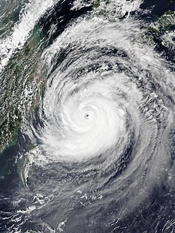
Maysak near peak intensity over the Ryukyu Islands on September 1