This article needs additional citations for verification .(June 2024) |
 Typhoon Nuri at peak intensity just north of Luzon on August 20 | |
| Meteorological history | |
|---|---|
| Formed | August 17,2008 |
| Dissipated | August 23,2008 |
| Typhoon | |
| 10-minute sustained (JMA) | |
| Highest winds | 140 km/h (85 mph) |
| Lowest pressure | 955 hPa (mbar);28.20 inHg |
| Category 3-equivalent typhoon | |
| 1-minute sustained (SSHWS/JTWC) | |
| Highest winds | 185 km/h (115 mph) |
| Lowest pressure | 948 hPa (mbar);27.99 inHg |
| Overall effects | |
| Fatalities | 20 direct |
| Missing | 23 |
| Damage | $85 million (2008 USD) |
| Areas affected | Philippines,Mainland China,Hong Kong |
| IBTrACS | |
Part of the 2008 Pacific typhoon season | |
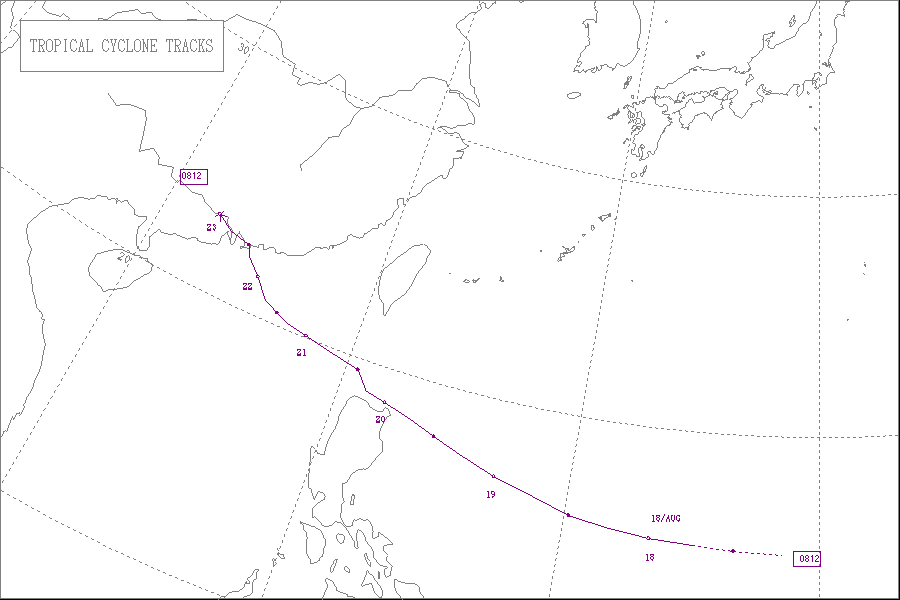
Typhoon Nuri,known in the Philippines as Typhoon Karen,was the 12th named storm and the seventh typhoon that was recognised by the Japan Meteorological Agency. The Joint Typhoon Warning Center recognised it as the 13th tropical depression,the 12th tropical storm and the 8th typhoon of the 2008 Pacific typhoon season. The name Nuri was submitted to the World Meteorological Organisation's Typhoon Committee by Malaysia in 2003 after the name Rusa was retired in 2002.[ citation needed ] The name Nuri is Malay for a blue crowned parroquet,a type of parrot. [1] The name Karen was assigned by PAGASA to a tropical depression for the second time,the other time being in 2004 to Typhoon Rananim. [2]
Contents
- Meteorological history
- Preparations
- Philippines
- Hong Kong
- Impact
- Philippines 2
- Hong Kong 2
- China
- See also
- References
- External links
Typhoon Nuri formed as a tropical depression on August 17 with the JMA then designating it as Tropical Storm Nuri the next day. It reached typhoon status later that day. Nuri then made landfall in the Philippines as a typhoon on August 20 leaving at least 10 people dead and 11 injured. Nuri then emerged into the South China Sea the next day and started moving towards Southern China. As Nuri moved closer towards Hong Kong,the Hong Kong Observatory issued its Increasing Gale or Storm Signal No. 9 for the first time since Typhoon Dujuan in 2003. Typhoon Nuri then made a direct hit on Hong Kong as a typhoon. [3] The JMA issued its final warning on August 23 as Typhoon Nuri was moving into Southern China.


