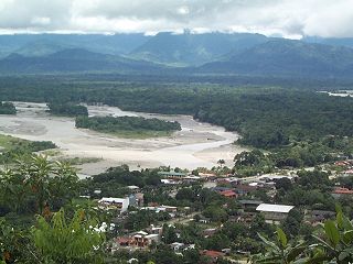
Chapare, also called The Chapare and is pronounced Cha-pa-reh, is a rural province in the northern region of Cochabamba Department in central Bolivia. The majority of the territory consists of valley rainforests that surround the area's main waterway, the Chapare River, which is also a tributary of the Amazon River. The provincial capital is Sacaba, 11 km east of Cochabamba, its principal town is Villa Tunari, a popular tourist destination.

Quillacollo is a province in the Cochabamba Department, Bolivia. It is known for its festival in August where people from all over Bolivia come and pay homage to the Virgin of Urqupiña. Quillacollo is said to be one of the fastest growing cities in Bolivia.

Quillacollo Municipality is the first municipal section of the Quillacollo Province in the Cochabamba Department, Bolivia. Its capital is Quillacollo. At the time of census 2001 the municipality had 104,206 inhabitants.

Villa Tunari Municipality is the third municipal section of the Chapare Province in the Cochabamba Department, Bolivia. Its seat is Villa Tunari. The population grew from 52,886 to 71,146 during 2001 to 2012 according to the census. Only 8,692 of the population are urban and are concentrated in the small towns of Villa Tunari (3.213), Eterazama (3,359) and Villa 14 the Septiembre (2,123). The municipality is famous for tourist especially the Villa Tunari town where the tourist industry is concentrated with infrastructure, and also because of the closeness of the Machia Park.

Jatunñaño Punta or Jatunñano Punta is a mountain in the Vilcanota mountain range in the Andes of Peru, about 5,812 metres (19,068 ft) high. It is situated in the Cusco Region, Canchis Province, Pitumarca District, and in the Quispicanchi Province, Marcapata District. Jatunñaño Punta lies north of the lake Sibinacocha.

Jatun Q'asa is a mountain in the Tunari mountain range of the Bolivian Andes, about 5,025 m (16,486 ft) high. It is situated north-west of Cochabamba in the Cochabamba Department, Quillacollo Province, in the west of the Quillacollo Municipality.
Puma Apachita is a mountain in the Tunari mountain range of the Bolivian Andes, about 4,920 m (16,142 ft) high. It is situated in the Cochabamba Department, Quillacollo Province, Quillacollo Municipality, northwest of Cochabamba. Puma Apachita lies southeast of Jatun Q'asa.
Wayna Tunari is a mountain in the Tunari mountain range of the Bolivian Andes which reaches a height of approximately 4,800 m (15,748 ft). It is situated in the Cochabamba Department, Ayopaya Province, Morochata Municipality, and in the Quillacollo Province, Vinto Municipality. It lies northwest of Tunari.
Q'illu Salli is a 4,918-metre-high (16,135 ft) mountain in the Andes of Bolivia. It is situated in the Potosí Department, Sud Lípez Province, San Pablo de Lípez Municipality. Q'illu Salli lies south-east of San Pablo de Lípez, south-west of the mountain Kuntur Wasi and south of the river Lluch'a Mayu (Llucha Mayu).
Punta Yavre or Punta Yayre is a mountain in the northeast of the Apolobamba mountain range on the border of Bolivia and Peru. It is about 4,600 metres (15,092 ft) high. On the Bolivian side it is located in the La Paz Department, Franz Tamayo Province, Pelechuco Municipality, and on the Peruvian side it lies in the Puno Region, Putina Province, Sina District. Punta Yavre is situated northwest and northeast of the mountains Chawpi Urqu and Kulli Pata.
Jatun Punta is a mountain in the Vilcanota mountain range in the Andes of Peru, about 5,200 metres (17,060 ft) high. It is situated in the Cusco Region, Quispicanchi Province, Ocongate District. Jatun Punta lies southwest of Callangate and west Puca Punta.
Q'ara Apachita is a 4,639 m (15,220 ft) mountain in the Bolivian Andes. It is located in the Cochabamba Department, Chapare Province, Villa Tunari Municipality.
Qillqata is a mountain in the Bolivian Andes which reaches a height of approximately 4,720 m (15,490 ft). It is located in the Cochabamba Department, Quillacollo Province, Quillacollo Municipality. Qillqata lies southeast of Uqi Salli Punta.
Pirwata is a 5,060-metre-high (16,600 ft) mountain in the Bolivian Andes. It is located in the Cochabamba Department, on the border of the Ayopaya Province, Morochata Municipality, and the Quillacollo Province, Quillacollo Municipality.
Wila Qullu Punta is a 4,739-metre-high (15,548 ft) mountain in the Bolivian Andes. It is located in the Cochabamba Department, Quillacollo Province, Quillacollo Municipality.
Q'illu Suchusqa is a mountain in the Bolivian Andes which reaches a height of approximately 4,480 m (14,700 ft). It is located in the Cochabamba Department, Quillacollo Province, Quillacollo Municipality. Q'illu Suchusqa lies southwest of Wila Qullu Punta.
Quna Quna Q'asa is a mountain in the Bolivian Andes which reaches a height of approximately 4,720 m (15,490 ft). It is located in the Cochabamba Department, Quillacollo Province, Quillacollo Municipality. Quna Quna Q'asa lies southeast of Wila Qullu Punta and Q'illu Suchusqa.
Kimsa Tinkuy is a mountain in the Bolivian Andes which reaches a height of approximately 4,720 m (15,490 ft). It is located in the Cochabamba Department, Quillacollo Province, Quillacollo Municipality. Kimsa Tinkuy lies northwest to west of Awila Wachana Punta and southeast of Quna Quna Q'asa.
Awila Wachana Punta is a mountain in the Bolivian Andes which reaches a height of approximately 4,720 m (15,490 ft). It is located in the Cochabamba Department, Quillacollo Province, Quillacollo Municipality. Awila Wachana Punta lies east of Kimsa Tinkuy and a lake named Warawarani.
Puka Salli is a mountain in the Bolivian Andes which reaches a height of approximately 4,640 m (15,220 ft). It is located in the Cochabamba Department, Quillacollo Province, Quillacollo Municipality. Puka Salli lies southeast of Awila Wachana Punta and northeast of a lake named Parinani Quta.