Villages at Roll Hill, Cincinnati

Last updated
Villages at Roll Hill
Fay-Apartments-Cincinnati-map.jpg
Villages at Roll Hill (red) within Cincinnati, Ohio
Country United States
State Ohio
County Hamilton
City Cincinnati
Population
 (2020)
  Total1,918

Villages at Roll Hill (formerly called Fay Apartments) is one of the 52 neighborhoods of Cincinnati, Ohio. The neighborhood predominantly consists of Section 8 housing. The population was 1,918 at the 2020 census. [1]

Contents

History

In the 1850s, Roll Hill was the site of tunneling project as part of the Cincinnati Western Railroad's attempt to build a standard-gauge track from Cincinnati to Chicago. The company went bankrupt in 1860, leaving the railroad tunnel under Roll Hill unfinished. [2]

Roll Hill was transformed into a public housing project in the 1960s, with the projects receiving the name Fay Apartments. [2] In the 2010s, the neighborhood's projects received a $36 million renovation. The neighborhood was renamed from Fay Apartments to Villages at Roll Hill in December 2012 during the renovations. [3]

Demographics

As of the census of 2020, there were 1,918 people living in the neighborhood. There were 744 housing units. The racial makeup of the neighborhood was 5.8% White, 83.3% Black or African American, 0.3% Native American, 0.2% Asian, 0.0% Pacific Islander, 3.1% from some other race, and 7.4% from two or more races. 6.4% of the population were Hispanic or Latino of any race. [1]

There were 844 households, out of which 82.5% were families. About 15.8% of all households were made up of individuals. [1]

66.0% of the neighborhood's population were under the age of 18, 32.8% were 18 to 64, and 1.2% were 65 years of age or older. 35.2% of the population were male and 64.8% were female. [1]

According to the U.S. Census American Community Survey, for the period 2016-2020 the estimated median annual income for a household in the neighborhood was $11,327. About 80.0% of family households were living below the poverty line. About 1.2% of adults had a bachelor's degree or higher. [1]

Related Research Articles

<span class="mw-page-title-main">Evanston, Cincinnati</span> Neighborhood of Cincinnati in Ohio, United States

Evanston is one of the 52 neighborhoods of Cincinnati, Ohio. A mostly African-American neighborhood since the 1960s, it is known as "the educating community," and is bordered by the neighborhoods of East Walnut Hills, Hyde Park, North Avondale, and Walnut Hills, as well as the City of Norwood. The population was 8,838 at the 2020 census.

<span class="mw-page-title-main">Clifton, Cincinnati</span> Neighborhood of Cincinnati in Ohio, United States

Clifton is is one of the 52 neighborhoods of Cincinnati, Ohio. The population was 8,408 in the 2020 census.

<span class="mw-page-title-main">California, Cincinnati</span> Neighborhood of Cincinnati in Ohio, United States

California, Cincinnati is one of the 52 neighborhoods of Cincinnati, Ohio. Located at the confluence of the Little Miami River and Ohio River, it is the southeastern-most neighborhood in the city. California borders the Cincinnati neighborhoods of Mt. Washington and the East End, as well as Anderson Township. The population was 944 at the 2020 census.

<span class="mw-page-title-main">Spring Grove Village, Cincinnati</span> Neighborhood of Cincinnati in Hamilton, Ohio, United States

Spring Grove Village is one of the 52 neighborhoods of Cincinnati, Ohio. Annexed in 1903, the neighborhood was known as Winton Place until 2007. It is located off Interstate 75 in the Mill Creek Valley. The population was 1,916 at the 2020 census.

<span class="mw-page-title-main">East Walnut Hills, Cincinnati</span> Place in Ohio, United States

East Walnut Hills is one of the 52 neighborhoods of Cincinnati, Ohio. Established in 1867 and annexed in 1873, it is located in the eastern side of the city. The population was 4,103 at the 2020 census.

<span class="mw-page-title-main">Westwood, Cincinnati</span> Neighborhood of Cincinnati in Hamilton, Ohio, United States

Westwood is one of the 52 neighborhoods of Cincinnati, Ohio. Annexed in 1896 and located in the western part of the city, it is the city's largest neighborhood in both area and population. The population was 33,774 at the 2020 census.

<span class="mw-page-title-main">College Hill, Cincinnati</span> Neighborhood of Cincinnati in Hamilton, Ohio, United States

College Hill is one of the 52 neighborhoods of Cincinnati, Ohio. Established in 1813 and annexed in 1911, 1915, and 1923, it is located in the northwestern part of the city. It was originally called Pleasant Hill due to its prime location, but was later renamed College Hill because of the two colleges that were established there in the mid-nineteenth century. The neighborhood is not to be confused with North College Hill, which borders College Hill to the north but is not part of Cincinnati. The population was 16,039 at the 2020 census.

<span class="mw-page-title-main">CUF, Cincinnati</span> Neighborhood

CUF is one of the 52 neighborhoods of Cincinnati, Ohio. Its name is derived from the communities of Clifton Heights, University Heights, and Fairview. These communities surround the University of Cincinnati to the south and west of its main campus, making CUF a predominantly residential, student neighborhood. The population was 20,385 at the 2020 census.

<span class="mw-page-title-main">East Westwood, Cincinnati</span> Neighborhood of Cincinnati in Ohio, United States

East Westwood is one of the 52 neighborhoods of Cincinnati, Ohio. The population was 2,458 at the 2020 census.

<span class="mw-page-title-main">English Woods, Cincinnati</span> Neighborhood of Cincinnati in Ohio, United States

English Woods is one of the 52 neighborhoods of Cincinnati, Ohio. Owned by the Cincinnati Metropolitan Housing Authority, the neighborhood originally consisted of housing projects built in 1940 and 1960, but the majority of the projects were demolished in 2005. The population was 361 at the 2020 census.

<span class="mw-page-title-main">Millvale, Cincinnati</span> Neighborhood of Cincinnati in Hamilton, Ohio, United States

Millvale is one of the 52 neighborhoods of Cincinnati, Ohio. The population was 1,965 at the 2020 census. Millvale is predominantly black. About a third of residents live in public housing.

<span class="mw-page-title-main">Mount Airy, Cincinnati</span> Neighborhood of Cincinnati in Hamilton, Ohio, United States

Mount Airy is one of the 52 neighborhoods of Cincinnati, Ohio. The neighborhood is home to Mount Airy Forest, one of the oldest urban reforestation projects in the country. The population was 9,210 at the 2020 census.

<span class="mw-page-title-main">North Fairmount, Cincinnati</span> Place in Ohio, United States

North Fairmount is one of the 52 neighborhoods of Cincinnati, Ohio. The neighborhood lies south of East Westwood, southwest of Millvale, and north of South Fairmount. The population was 1,590 at the 2020 census.

<span class="mw-page-title-main">West End, Cincinnati</span> Neighborhood of Cincinnati in Ohio, United States

West End is one of the 52 neighborhoods of Cincinnati, Ohio. Originally a large residential neighborhood, the majority of the area was demolished in the mid-20th century for the construction of highway interchanges and an industrial park known as Queensgate. The population was 6,824 at the 2020 census.

<span class="mw-page-title-main">Walnut Hills, Cincinnati</span> Neighborhood of Cincinnati in Ohio, United States

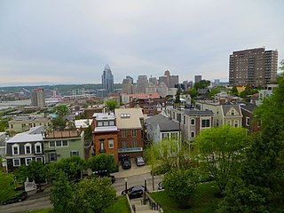
Walnut Hills is one of the 52 neighborhoods of Cincinnati, Ohio. One of the city's oldest hilltop neighborhoods, it is a large diverse area on the near east side of Cincinnati. The population was 6,344 in the 2020 census.

<span class="mw-page-title-main">Riverside, Cincinnati</span> Neighborhood of Cincinnati in Hamilton, Ohio, United States

Riverside is one of the 52 neighborhoods of Cincinnati, Ohio. The neighborhood is contained in a narrow strip of land along the Ohio River on the city's west side, between Sayler Park and Sedamsville. Predominately industrial, the neighborhood has few residential areas, with a population of 1,257 at the 2020 census.

<span class="mw-page-title-main">Roselawn, Cincinnati</span> Neighborhood of Cincinnati in Hamilton, Ohio, United States

Roselawn is one of the 52 neighborhoods of Cincinnati, Ohio. The population was 7,039 at the 2020 census.

<span class="mw-page-title-main">South Cumminsville, Cincinnati</span> Neighborhood of Cincinnati in Ohio, United States

South Cumminsville is one of the 52 neighborhoods of Cincinnati, Ohio. The population was 702 at the 2020 census.

<span class="mw-page-title-main">South Fairmount, Cincinnati</span> Neighborhood of Cincinnati in Ohio, United States

South Fairmount is one of the 52 neighborhoods of Cincinnati, Ohio. Located in the western part of the city, it contains one of the highest concentrations of Section 8 housing in Hamilton County. The population was 2,181 at the 2020 census.

<span class="mw-page-title-main">Hartwell, Cincinnati</span> Neighborhood of Cincinnati in Hamilton, Ohio, United States

Hartwell is one of the 52 neighborhoods of Cincinnati, Ohio. Established in 1868 and annexed in 1912, it is the city's northernmost neighborhood, centered roughly on the intersections of I-75 and Ronald Reagan Cross County Highway. Its boundaries are a combination of Caldwell Park and Ronald Reagan Cross County Highway to the south, I-75 to the east, and a combination of Millsdale Street and Compton Road to the North. The population was 5,806 at the 2020 census.

References

  1. 1 2 3 4 5 "Roll Hill 2020 Statistical Neighborhood Approximation" (PDF). City of Cincinnati. Retrieved 1 January 2024.
  2. 1 2 Coleman, Brent (21 May 2016). "1850s locomotive may lay buried under Roll Hill". WCPO 9 News. Retrieved 1 January 2024.
  3. "Troubled apartment complex nearing end of $36M renovation". WLWT5. 4 December 2012. Retrieved 1 January 2024.

39°09′22″N84°33′38″W / 39.156097°N 84.560600°W / 39.156097; -84.560600