Villarroya de los Pinares

Last updated

Villarroya de los Pinares, Spain
Vista de Villarroya desde el Mirador de Villarroya (Villarroya de los Pinares, Teruel, Aragon).jpg
Nickname: 
Villarroya
Spain location map with provinces.svg
Red pog.svg
Villarroya de los Pinares, Spain
Coordinates: 40°32′N0°40′W / 40.533°N 0.667°W / 40.533; -0.667
CountryFlag of Spain.svg  Spain
Autonomous community Flag of Aragon.svg Aragon
Province Flag of Teruel (province).svg Teruel
Region Maestrazgo
Area
  Total66.41 km2 (25.64 sq mi)
Elevation
1,337 m (4,386 ft)
Population
 (2018) [1]
  Total160
  Density2.4/km2 (6.2/sq mi)
Time zone UTC+1 (CET)
Website http://www.villarroyadelospinares.es

Villarroya de los Pinares is a municipality located in the Maestrazgo [2] region, province of Teruel, Aragon, Spain. According to the 2004 census (INE), the municipality had a population of 190 inhabitants.

Contents

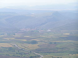
It is in the northern part of the Gúdar mountain range next to the Guadalope River at an altitude of 1,337 meters and at a distance of 51 km from the provincial capital, Teruel on the A-226 road.

Local Policy

Last mayors of Villarroya de los Pinares

PeriodMayorParty
1979–1983Juan Ramón López Ariño [3] [4]
1983–1987
1987–1991
1991–1995
1995–1999
1999–2003
2003–2007
2007–2011
2011–2015Arturo Martín Calvo [5]

Demography

Like many other municipalities in the province of Teruel and the province as a whole, Villarroya de los Pinares has a low population density (close to 3 inhabitants / km²). For decades, the municipality has experienced a gradual depopulation of its territory, in parallel to the aging of its inhabitants, as has happened in so many other places of mainly agricultural and livestock vocation, located in the plateaus and mountain ranges of inland Spain.

Demographic Evolution [6] [7] [8]
Year1900191019201930194019501960197019801981
Population1,095942875772641628574400249
Year1991199219931994199519961997199819992000
Population218214203200201
Year2001200220032004200520062007200820092010
Population192196193190188194194187190177
Year2011201220132014201520162017201820192020
Population172163164160163160155160172161
Year2021202220232024202520262027202820292030
Population187

Economy

Traditionally, its source of livelihood is agriculture and livestock. More recently, rural tourism has begun to become one more reason to visit the municipality. Nearby are the ski slopes of the Sierra de Gúdar. The abundant hunting and fishing are additional attractions.

Buildings

Hermitage of San Benon, Villarroya de los Pinares (Teruel). Ermita de San Benon, Villarroya de los Pinares (Teruel).jpg
Hermitage of San Benón, Villarroya de los Pinares (Teruel).
Tower in Villarroya de los Pinares. Torreon (Villarroya de los Pinares, Teruel, Aragon).jpg
Tower in Villarroya de los Pinares.
Alegre y Pellicer Ancestral Home. Alegre y Pellicer ancestral home.jpg
Alegre y Pellicer Ancestral Home.

The municipality of Villarroya de los Pinares was declared a Historic-artistic Site in 1982. Many historic buildings in the urban area are crowned with ancient shields and inscriptions.

The municipality's Gothic church, built-in 1459 and dedicated to the Virgen de la Asunción, has a remarkable polygonal apse and a porticoed gallery. It has undergone several repairs since then. Cardinal Francisco Peña, who always harbored the dream of transforming it into a cathedral, lies buried in it.

The hermitage built in honor of the patron saint of the place, San Benón, stands in the vicinity of the municipality. Also, in the vicinity of this, is the castle in ruins that belonged to James I of Aragón, King of Aragon, Count of Barcelona, and Lord of Montpellier.

Festivals

Two patron saint festivals are celebrated in the village, one on 16 June in honor of San Benón, and the other on 25 July in honor of St. James the Apostle.

Illustrious personages

Images

See also

Related Research Articles

<span class="mw-page-title-main">Benabarre</span> Municipality in Aragon, Spain

Benabarre, in Ribagorçan and Aragonese: Benavarri is a town and municipality in the Aragonese comarca of Ribagorza, in the province of Huesca, Spain.

<span class="mw-page-title-main">Province of Teruel</span> Province of Spain

Teruel is a province of Aragon, in the northeast of Spain. The capital is Teruel.

<span class="mw-page-title-main">Comarcas of Spain</span> Divisions of some autonomous communities in Spain

In Spain, a comarca is either a traditional territorial division without any formal basis, or a group of municipalities, legally defined by an autonomous community for the purpose of providing common local government services. In English, a comarca is equivalent to a district, county, area or zone.

<span class="mw-page-title-main">First Carlist War</span> Civil war in Spain from 1833 to 1840

The First Carlist War was a civil war in Spain from 1833 to 1840, the first of three Carlist Wars. It was fought between two factions over the succession to the throne and the nature of the Spanish monarchy: the conservative and devolutionist supporters of the late king's brother, Carlos de Borbón, became known as Carlists (carlistas), while the progressive and centralist supporters of the regent, Maria Christina, acting for Isabella II of Spain, were called Liberals (liberales), cristinos or isabelinos. Aside from being a war of succession about the question who the rightful successor to king Ferdinand VII of Spain was, the Carlists’ goal was the return to a traditional monarchy, while the Liberals sought to defend the constitutional monarchy.

<span class="mw-page-title-main">Berge, Teruel</span> Place in Aragon, Spain

Berge is a little village and municipality in Bajo Aragón, Teruel Province, Aragon, Spain. According to the 2010 census the municipality has a population of 274 inhabitants.

Novales is a municipality located in the province of Huesca, Aragon, Spain. According to the 2004 census (INE), the municipality has a population of 191 inhabitants. It is situated on a plain on the right bank of the river Guatizalema, about 16 km Southeast of Huesca.

<span class="mw-page-title-main">Abejuela</span> Place in Aragon, Spain

Abejuela is a municipality located in the province of Teruel, Aragon, Spain. According to the 2018 census (INE), the municipality has a population of 49 inhabitants. It is the southernmost town in Aragon.

<span class="mw-page-title-main">Bordón</span> Place in Aragon, Spain

Bordón is a municipality located in the province of Teruel, Aragon, Spain. According to the 2010 census the municipality has a population of 141 inhabitants.

<span class="mw-page-title-main">Villarluengo</span> Place in Aragon, Spain

Villarluengo is a municipality at the heart of the mountainous Maestrazgo comarca, province of Teruel, Aragon, Spain. According to the 2010 census the municipality has a population of 188 inhabitants.

<span class="mw-page-title-main">Molinos, Teruel</span> Place in Aragon, Spain

Molinos is a municipality located in the Maestrazgo comarca, province of Teruel, Aragon, Spain. According to the 2010 census the municipality has a population of 303 inhabitants.

Villarroya may refer to:

<span class="mw-page-title-main">Battle of Maella</span> Battle of the First Carlist War

The Battle of Maella took place during the First Carlist War on Monday, October 1, 1838, near the Aragonese town of Maella. The battle was a Carlist victory and resulted in the routing of most of the Liberal forces.

<span class="mw-page-title-main">Guadalope</span> River in Spain

The Guadalope is a river in Aragon, Spain. It is a tributary of the Ebro.

<span class="mw-page-title-main">Cincomarzada</span>

The Cincomarzada was a failed Carlist attempt to conquer the city of Zaragoza on 5 March 1838. Nowadays it is a popular holiday in Zaragoza commemorating the heroic behaviour of the citizens during the First Carlist War.

<span class="mw-page-title-main">Maestrazgo</span> Natural region in Spain

The Maestrazgo or Maestrat is a natural and historical mountainous region, located at the eastern end of the Sistema Ibérico mountain range, in Spain. It encompasses the north of the Autonomous Community of Valencia, in Castellón province, and parts of the east of the Aragonese province of Teruel. The area is mountainous and sparsely populated with a rich mixture of flora and fauna.

<span class="mw-page-title-main">Maestrazgo, Aragon</span> Comarca in Aragon, Spain

Maestrazgo is a comarca in southeastern Aragon, Spain. Its names derives from the Maestrat/Maestrazgo mountain massif that extends to the east to the Comarques of the Valencian Community Alt Maestrat and Baix Maestrat. The most important town is Cantavieja. It is bordered by the Aragonese comarcas of Andorra-Sierra de Arcos, Cuencas Mineras, Comunidad de Teruel and Bajo Aragón, in the north and in the west and Gúdar-Javalambre in the south, as well as with the Castellón Province in the east. Some municipal terms of this comarca are part of the historical region of Lower Aragon.

<span class="mw-page-title-main">Sierra de Gúdar</span>

Sierra de Gúdar is a mountain range in the Gúdar-Javalambre and Maestrazgo comarcas of Aragon and the Alto Mijares comarca of the Valencian Community, Spain. The highest point in the range is Peñarroya (2,019 m).

<span class="mw-page-title-main">Sierra Carrascosa</span> Mountain range in Aragon, Teruel Province, Spain

Sierra Carrascosa is a mountain range in the Maestrazgo comarca of Aragon, Teruel Province, Spain. The highest point in the range is Muela Carrascosa (1,214 m). The Guadalope River flows along the NW side of the range.

<span class="mw-page-title-main">Sierra de Caballos</span>

Sierra de Caballos or Sierra de los Caballos is a mountain range in the Maestrazgo and Bajo Aragón comarcas of Aragon, Teruel Province, Spain. The highest point in the range is Las Artigas (1,205 m). The Guadalopillo River flows along the northern side of the range.

The Battle of Mayals(Spanish pronunciation:[majals]) in Catalonia was fought in the afternoon of April 10, 1834 between a Carlist force led by Manuel Carnicer Griñón and a Liberal force led by José Carratalá near the town of Mayals. The Liberal victory negatively affected Carlism's spread in the region in the early stages of the war.

References

  1. Municipal Register of Spain 2018. National Statistics Institute.
  2. "Maestrazgo".
  3. Ministerio de Hacienda y Administraciones Públicas (Gobierno de España). "Treinta aniversario de las primeras elecciones municipales de la democracia".
  4. "Secretaría de Estado de Administraciones Públicas". Archived from the original on 6 March 2014.
  5. Alcaldes de Aragón de las elecciones de 2011
  6. "Instituto Nacional de Estadistica: Official Population Figures referring to revision of Municipal Register 1 January".
  7. VILLARROYA DE LOS PINARES, Municipality in Teruel Province | CityPopulation.de
  8. Current Time in Villarroya de los Pinares, Aragon, Spain | GeneralBlue
  9. Stefan Bauer (2020). The Invention of Papal History: Onofrio Panvinio between Renaissance and Catholic Reform. Oxford.
  10. "Gran Encyclopedia Aragonesa – Carlistas, Guerras".
  11. "Gobierno de Aragon – Documents and Archives of Aragon (DARA)".
  12. Lafuente, Modesto (1890). Historia general de España desde los tiempos primitivos hasta la muerte de Fernando VII (in Spanish). Montaner y Simón.
  13. Mayor, Spain Ejército Cuerpo de Estado (1888). Narración militar de la guerra carlista de 1869 á 1876 (in Spanish). Impr. del Departmentósito de la Guerra.
  14. Conxa, Rodríguez Vives (22 February 2019). Los exilios de Ramón Cabrera (in Spanish). Prensas de la Universidad de Zaragoza. ISBN   978-84-17633-40-0.
  15. "DARA :: Detalle de Registro". aplicaciones.aragon.es.