This article needs additional citations for verification .(April 2024) |
Estercuel | |
|---|---|
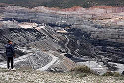 Coal mine in Estercuel | |
 Flag  Coat of arms | |
 | |
| Coordinates: 40°51′N0°38′W / 40.850°N 0.633°W | |
| Country | Spain |
| Autonomous community | Aragon |
| Province | Teruel |
| Area | |
• Total | 55 km2 (21 sq mi) |
| Elevation | 829 m (2,720 ft) |
| Population (2018) [1] | |
• Total | 210 |
| • Density | 3.8/km2 (9.9/sq mi) |
| Time zone | UTC+1 (CET) |
| • Summer (DST) | UTC+2 (CEST) |
Estercuel is a municipality located in the province of Teruel, Aragon, Spain. According to the 2004 census (INE), the municipality has a population of 314 inhabitants.