
Zaragoza, also called Saragossa in English, is a province of northern Spain, in the central part of the autonomous community of Aragon. Its capital is the city of Zaragoza, which is also the capital of the autonomous community. Other towns in the province include La Almunia de Doña Godina, Borja, Calatayud, Caspe, Ejea de los Caballeros, Tarazona, and Utebo.
Teruel is a province of Aragon, in the northeast of Spain. The capital is Teruel.

Matarraña or Matarranya is a comarca in eastern Aragon, bordering the Spanish Autonomous Communities of Catalonia and Valencia. It is located in Teruel Province, in the mountainous Sistema Ibérico area.

Manzanera is a small town and municipality in the province of Teruel, part of the autonomous community of Aragón, Spain. It is in the Gúdar-Javalambre comarca and it has 540 people. It is close to the ski area called Javalambre.

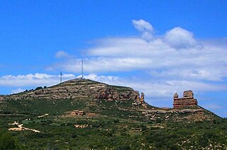
Berge is a little village and municipality in Bajo Aragón, Teruel Province, Aragon, Spain. According to the 2010 census the municipality has a population of 274 inhabitants.

La Puebla de Híjar is a town and municipality in the Bajo Martín comarca, Teruel province, Aragón, Spain. It has a population of 1,046, an area of 61 km² and is located near N-232 road.

The N-211 is a highway in Aragon, Spain. It connects the Autovía A-2 between Alcolea del Pinar and Fraga through Monreal del Campo, Alcañiz and Caspe, communicating Madrid with Catalonia. It is an alternative route for N-II/A-2.

Aguaviva or Aiguaviva de Bergantes is a municipality located in the province of Teruel, Aragon, Spain. According to the 2018 census (INE), the municipality had a population of 522 inhabitants.
Alcorisa is a municipality in the province of Teruel, Aragon, Spain. According to the 2018 census the municipality has a population of 3,276 inhabitants.

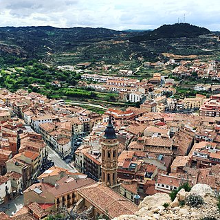
Calamocha is a town and municipality of Teruel province in the autonomous community of Aragon, Spain. In 2015 the municipality had a population of 4,417 inhabitants.
Jatiel is a municipality located in the Bajo Martín comarca, province of Teruel, Aragon, Spain. According to the 2010 census the municipality has a population of 52 inhabitants. Its postal code is 44592.

Mas de las Matas is a municipality in the province of Teruel, Aragon, Spain. According to the 2018 census (INE), the municipality has a population of 1,299 inhabitants.

La Mata de los Olmos is a municipality located in the Bajo Aragón comarca, province of Teruel, Aragon, Spain. According to the 2018 census the municipality has a population of 265 inhabitants.

Villarroya de los Pinares is a municipality located in the Maestrazgo region, province of Teruel, Aragon, Spain. According to the 2004 census (INE), the municipality had a population of 190 inhabitants.
Vinaceite is a municipality located in the Bajo Martín comarca, province of Teruel, Aragon, Spain. According to the 2004 census (INE), the municipality had a population of 281 inhabitants.
Bello is a municipality located in the province of Teruel, Aragon, Spain. According to the 2003 census (INE), the municipality has a population of 369 inhabitants.

Santa Eulalia del Campo is a municipality located in the province of Teruel, Aragon, Spain. According to the 2005 census (INE), the municipality has a population of 1,171 inhabitants.

Seno is a municipality located in the Bajo Aragon area, close to Maestrazgo in province of Teruel, Aragon, Spain, at an altitude of 792 m. According to the 2018 census the municipality has a population of 39 inhabitants.
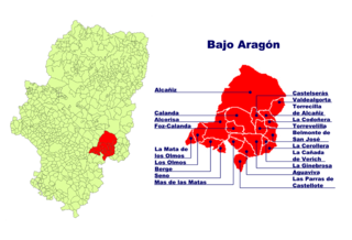
Bajo Aragón, or Lower Aragon, is an administrative comarca in eastern central Aragon, Spain. It was first established in 1999. It has a population of 29,358 (2007) and an area of 1.304,2 km2. The seat of the comarca is in Alcañiz. It is located in Teruel Province, in the transitional area between the Iberian System and the Ebro Valley.

Lower Aragon, also known as Tierra Baja, is a natural and historical region in Aragon, Spain. The name "Lower Aragon" refers to the areas of the lowest altitude within the Ebro river basin, but the historical region encompasses only the river basins of several right tributaries of the Ebro River, namely the Matarranya, Guadalope, Regallo, Martín and Aguas, located between the Ebro and the Iberian mountain range.

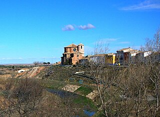
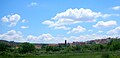 View of Los Olmos


