This article needs additional citations for verification .(May 2024) |
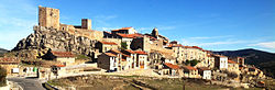
Puertomingalvo | |
|---|---|
 | |
 Coat of arms | |
 | |
| Coordinates: 40°16′N0°27′W / 40.267°N 0.450°W | |
| Country | Spain |
| Autonomous community | Aragon |
| Province | Teruel |
| Municipality | Puertomingalvo |
| Area | |
• Total | 103.62 km2 (40.01 sq mi) |
| Elevation | 1,449 m (4,754 ft) |
| Population (2025-01-01) [1] | |
• Total | 135 |
| • Density | 1.30/km2 (3.37/sq mi) |
| Time zone | UTC+1 (CET) |
| • Summer (DST) | UTC+2 (CEST) |
Puertomingalvo is a municipality located at high elevation in the province of Teruel, Aragon, Spain. According to the 2004 census (INE), the municipality has a population of 182 inhabitants.
Contents
This town is located close to the Sierra de Mayabona, part of the Iberian System.