Calanda, Spain

Last updated

Calanda
Vista parcial de Calanda.jpg
Coat of Arms of Calanda.svg
Spain Aragon location map.svg
Red pog.svg
Calanda
Location in Aragon
Spain location map with provinces.svg
Red pog.svg
Calanda
Location in Spain
Coordinates: 40°56′27″N0°13′54″W / 40.94083°N 0.23167°W / 40.94083; -0.23167
Country Flag of Spain.svg  Spain
Autonomous community Flag of Aragon.svg  Aragon
Province Teruel
Comarca Bajo Aragón
Government
   Mayor José Ramón Ibáñez Blasco
(PSOE de Aragón) (2015–2019)
Area
  Total
112.25 km2 (43.34 sq mi)
Population
 (2018) [1]
  Total
3,708
  Density33/km2 (86/sq mi)
Demonym Calandino
Time zone UTC+1 (CET)
  Summer (DST) UTC+2 (CEST)

Calanda is a town in the province of Teruel, Aragon, Spain. It lies on the southern fringe of the Ebro river basin, at the confluence of the Rivers Guadalope and Guadalopillo.

Contents

The local economy is based upon agriculture, especially the cultivation of peaches and olives, both of which have Protected Designation of Origin status: Melocotón de Calanda in the case of the peach production and Aceite del Bajo Aragón for the olive oil. Other agricultural products are almonds and other fruits as well as some cereals.

Historic structures

Demographics

Demographic evolution of Calanda between 1716 and 2007
2007200420011996199119081901182417711716
3897359834743596355244083876245621601258

Geography

Located in the Lower Aragon region, it is 128 km from the provincial capital. The relief of the municipality is formed by the foothills of the Iberian System, to which belong the Mountain range of Peñas Blancas (669 m) and the Ginebrosa mountain range (835 m), both located to the south and southeast and separated by the Calanda reservoir. To the north it connects with the valley of the Guadalope River, which crosses the territory receiving the waters of the Guadalopillo River. Also noteworthy is the leafy pine forest of the Calanda Desert, located to the northwest of the town. The altitude ranges between 835 m (Sierra de la Ginebrosa) and 380 m on the banks of the Guadalope River. The town is 466 m above sea level.

Climate

Calanda has a cold semi-arid climate on the Köppen climate classification (BSk) with cool to mild winters and hot summers. Temperatures below 0 °C (32 °F) and temperatures above 35 °C (95 °F) are common during the winter and the summer, respectively. Precipitation is generally low, being well distributed throughout the year, although there is an increase during spring. The city has higher average annual temperatures due to its lower altitude compared to other areas in the province of Teruel, which have lower temperatures due to their higher altitude. [2]

Climate data for Calanda (1991-2020), extremes (1990-present)
MonthJanFebMarAprMayJunJulAugSepOctNovDecYear
Record high °C (°F)22.5
(72.5)
23.0
(73.4)
29.9
(85.8)
31.0
(87.8)
35.9
(96.6)
43.2
(109.8)
43.0
(109.4)
41.6
(106.9)
36.9
(98.4)
33.1
(91.6)
25.3
(77.5)
22.8
(73.0)
43.2
(109.8)
Mean daily maximum °C (°F)11.0
(51.8)
12.7
(54.9)
16.5
(61.7)
19.1
(66.4)
23.5
(74.3)
28.8
(83.8)
32.1
(89.8)
31.3
(88.3)
26.2
(79.2)
21.0
(69.8)
14.6
(58.3)
11.3
(52.3)
20.7
(69.2)
Daily mean °C (°F)6.9
(44.4)
8.1
(46.6)
11.0
(51.8)
13.5
(56.3)
17.5
(63.5)
22.1
(71.8)
25.1
(77.2)
24.6
(76.3)
20.4
(68.7)
16.1
(61.0)
10.5
(50.9)
7.3
(45.1)
15.3
(59.5)
Mean daily minimum °C (°F)2.8
(37.0)
3.5
(38.3)
5.5
(41.9)
7.9
(46.2)
11.4
(52.5)
15.4
(59.7)
18.0
(64.4)
17.9
(64.2)
14.7
(58.5)
11.2
(52.2)
6.3
(43.3)
3.3
(37.9)
9.8
(49.7)
Record low °C (°F)−7.0
(19.4)
−5.0
(23.0)
−7.0
(19.4)
−1.2
(29.8)
1.3
(34.3)
4.5
(40.1)
10.5
(50.9)
7.0
(44.6)
6.0
(42.8)
1.0
(33.8)
−4.0
(24.8)
−8.0
(17.6)
−8.0
(17.6)
Average precipitation mm (inches)26.6
(1.05)
20.7
(0.81)
25.9
(1.02)
40.5
(1.59)
56.3
(2.22)
33.7
(1.33)
28.4
(1.12)
34.9
(1.37)
39.6
(1.56)
41.3
(1.63)
33.8
(1.33)
24.8
(0.98)
406.5
(16.01)
Source: Agencia Estatal de Meteorología [3]

Notable natives and residents

See also

Sister cities

Bibliography

Filmography

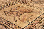
Archaeology: Camino de la Vega de Albalate

See also

References

  1. Municipal Register of Spain 2018. National Statistics Institute.
  2. "Valores Climatologicos normales". AEMET. Retrieved 15 December 2024.
  3. "AEMET OpenData". Aemet.es. Retrieved 15 December 2024.