La Puebla de Valverde

Last updated
La Puebla de Valverde
Muralla lejana.JPG
Escudo de La Puebla de Valverde.svg
Gudar-Javalambre.png
Spain location map with provinces.svg
Red pog.svg
La Puebla de Valverde
Location in Spain
Coordinates: 40°13′N0°55′W / 40.217°N 0.917°W / 40.217; -0.917
CountryFlag of Spain.svg  Spain
Autonomous community Flag of Aragon.svg  Aragón
Province Teruel
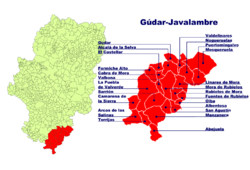
Comarca Gúdar-Javalambre
Judicial district Teruel
Government
   Alcaldesa María Luisa Fuertes Alegría (2007)
Area
  Total282.78 km2 (109.18 sq mi)
Elevation
1,183 m (3,881 ft)
Population
 (2018) [1]
  Total453
  Density1.6/km2 (4.1/sq mi)
Demonym(s) Pueblano, -a
Time zone UTC+1 (CET)
  Summer (DST) UTC+2 (CEST)
Postal code
44450

La Puebla de Valverde is a municipality located in the province of Teruel, Aragon, Spain. According to the 2004 census (INE), the municipality had a population of 508 inhabitants.

Contents

This town is located at the feet of the Sierra de Camarena, Sistema Ibérico.

See also

Related Research Articles

<span class="mw-page-title-main">Province of Teruel</span> Province of Spain

Teruel is a province of Aragon, in the northeast of Spain. The capital is Teruel.

Valverde may refer to:

<span class="mw-page-title-main">Benavente, Zamora</span> Place in Castile and León, Spain

Benavente is a town and municipality in the north of the province of Zamora, in the autonomous community Castile and León of Spain. It has about 20,000 inhabitants.

<span class="mw-page-title-main">Alcañiz</span> Place in Aragon, Spain

Alcañiz is a town and municipality of Teruel province in the autonomous community of Aragon, Spain. The town is located on the banks of the river Guadalope. Alcañiz is the unofficial capital of the Lower Aragon historical region. It lies some 113 km (70 mi) from Teruel, the provincial capital, and 92 km (57 mi) from Zaragoza, the capital of Aragon.

<span class="mw-page-title-main">La Puebla de Híjar</span> Place in Aragon, Spain

La Puebla de Híjar is a town and municipality in the Bajo Martín comarca, Teruel province, Aragón, Spain. It has a population of 1,046, an area of 61 km² and is located near N-232 road.

<span class="mw-page-title-main">Santiago de la Puebla</span> Municipality in Castile and León, Spain

Santiago de la Puebla is a village and municipality in the province of Salamanca, western Spain, part of the autonomous community of Castile-Leon. It is located 54 kilometres from the provincial capital city of Salamanca and has a population of 417 people.

Cañada may refer to:

<span class="mw-page-title-main">Calamocha</span> Municipality in Aragon, Spain

Calamocha is a town and municipality of Teruel province in the autonomous community of Aragon, Spain. In 2015 the municipality had a population of 4,417 inhabitants.

Camarillas is a municipality located in the province of Teruel, Aragon, Spain. According to the 2022 census (INE), the municipality has a population of 84 inhabitants.

Lanzuela is a municipality located in the province of Teruel, Aragon, Spain. According to the 2010 census the municipality has a population of 102 inhabitants.

<span class="mw-page-title-main">La Mata de los Olmos</span> Municipality in Aragon, Spain

La Mata de los Olmos is a municipality located in the Bajo Aragón comarca, province of Teruel, Aragon, Spain. According to the 2018 census the municipality has a population of 265 inhabitants.

<span class="mw-page-title-main">Rubielos de la Cérida</span> Place in Aragon, Spain

Rubielos de la Cérida is a municipality located in the province of Teruel, Aragon, Spain. According to the 2010 census the municipality had a population of 45 inhabitants. Its postal code is 44166

<span class="mw-page-title-main">Villarroya de los Pinares</span> Municipality in Aragon, Spain

Villarroya de los Pinares is a municipality located in the Maestrazgo region, province of Teruel, Aragon, Spain. According to the 2004 census (INE), the municipality had a population of 190 inhabitants.

Cucalón is a municipality located in the province of Teruel, Aragon, Spain. According to the 2010 census the municipality has a population of 102 inhabitants. This town gives its name to the Sierra de Cucalón system of mountain ranges.

Puebla is a Mexican state.

<span class="mw-page-title-main">Campiña Sur (Badajoz)</span> Comarca in Extremadura, Spain

Campiña Sur is an administrative division (comarca) in the province of Badajoz, Extremadura, Spain. Its capital and administrative center is the municipality of Llerena. It contains 21 municipalities and 32,841 inhabitants in an area of 2,798 square kilometres (1,080 sq mi).

Montalbán or Montalban may refer to:

<span class="mw-page-title-main">Escandón Pass</span> Mountain pass in Teruel Province, Aragon, Spain

The Escandón Pass is a mountain pass in Teruel Province, Aragon, Spain. It is located in La Puebla de Valverde municipal term, in the Sierra de Gúdar and Sierra de Javalambre zone, where the Iberian System ranges begin to descend towards the sea.

<span class="mw-page-title-main">Tierra de Mérida - Vegas Bajas</span> Comarca in Extremadura, Spain

Tierra de Mérida - Vegas Bajas is a comarca in the province of Badajoz, Extremadura, Spain. It contains the following municipalities:

<span class="mw-page-title-main">Vía Verde de Ojos Negros</span> Greenway in Spain

The Ojos Negros Greenway, is a 160-kilometre greenway in Spain running between the village of Santa Eulalia del Campo in the province of Teruel in Aragón and the village of Algimia d'Alfara, in the province of Valencia in the Valencian Community.

References

  1. Municipal Register of Spain 2018. National Statistics Institute.