This article needs additional citations for verification .(August 2012) |
Cabra de Mora | |
|---|---|
 | |
 Flag  Coat of arms | |
 Cabra de Mora Location of Cabra de Mora in Spain | |
| Coordinates: 40°19′3″N0°48′26″W / 40.31750°N 0.80722°W | |
| Country | |
| Autonomous community | |
| Province | |
| Comarca | Gúdar-Javalambre |
| Judicial District | Teruel [1] |
| Government | |
| • Mayor (2011) | Manuel de la Poza Moreno |
| Area | |
• Total | 34.31 km2 (13.25 sq mi) |
| Elevation | 1,085 m (3,560 ft) |
| Population (2018) [4] | |
• Total | 55 |
| • Density | 1.6/km2 (4.2/sq mi) |
| Time zone | UTC+01:00 (CET) |
| • Summer (DST) | UTC+02:00 (CEST) |
| Postal code | 44409 |
| Demonym | Egabrense |
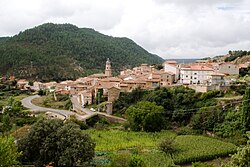
Cabra de Mora is a municipality in the province of Teruel, Aragon, Spain. According to the 2004 census (INE), it had a population of 119. By 2018, the population had declined to just 55 residents [5] reflecting a steady decrease since 2007.