Fortanete | |
|---|---|
 | |
 | |
 Fortanete Location in Spain | |
| Coordinates: 40°30′21″N0°31′15″W / 40.50583°N 0.52083°W | |
| Country | |
| Autonomous community | |
| Province | Teruel |
| Comarca | Maestrazgo |
| Judicial district | Teruel |
| Founded | 1169 |
| Government | |
| • Alcaldesa | José Luis Monserrate Gil (2007) (PSOE) |
| Area | |
• Total | 168.21 km2 (64.95 sq mi) |
| Elevation | 1,353 m (4,439 ft) |
| Population (2025-01-01) [1] | |
• Total | 195 |
| • Density | 1.16/km2 (3.00/sq mi) |
| Demonym(s) | Fortanetino, -a |
| Time zone | UTC+1 (CET) |
| • Summer (DST) | UTC+2 (CEST) |
| Postal code | 44143 |
| Dialing code | 978 |
| Website | Official website |
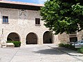
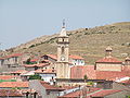
Fortanete is a municipality located in the province of Teruel, Aragon, Spain. According to the 2004 census (INE), the municipality has a population of 202 inhabitants.