This article needs additional citations for verification .(January 2018) |
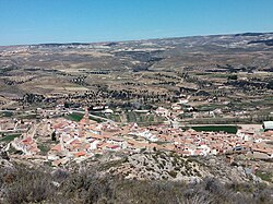
Oliete | |
|---|---|
 | |
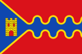 Flag  Coat of arms | |
 | |
| Coordinates: 40°59′N0°40′W / 40.983°N 0.667°W | |
| Country | Spain |
| Autonomous community | Aragon |
| Province | Teruel |
| Municipality | Oliete |
| Government | |
| • Mayor | Rogelio Villanueva Lazaro (PAR) |
| Area | |
• Total | 85 km2 (33 sq mi) |
| Population (2025-01-01) [1] | |
• Total | 351 |
| • Density | 4.1/km2 (11/sq mi) |
| Time zone | UTC+1 (CET) |
| • Summer (DST) | UTC+2 (CEST) |
Oliete is a municipality located in the province of Teruel, Aragon, Spain. According to the 2017 census (INE), the municipality has a population of 357 inhabitants.