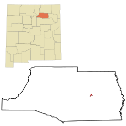
Wagon Mound, New Mexico | |
---|---|
Coordinates: 36°0′26″N104°42′26″W / 36.00722°N 104.70722°W | |
Country | United States |
State | New Mexico |
County | Mora |
Area | |
• Total | 1.01 sq mi (2.62 km2) |
• Land | 1.01 sq mi (2.62 km2) |
• Water | 0.00 sq mi (0.00 km2) |
Elevation | 6,201 ft (1,890 m) |
Population | |
• Total | 266 |
• Density | 262.85/sq mi (101.52/km2) |
Time zone | UTC−07:00 (Mountain (MST)) |
• Summer (DST) | UTC−06:00 (MDT) |
ZIP Codes | 87735, 87752 |
Area code | 575 |
FIPS code | 35-83340 |
GNIS feature ID | 0915913 |
Website | sangres |
Wagon Mound is a village in Mora County, New Mexico, United States. It is named after and located at the foot of a butte called Wagon Mound, which was a landmark for covered wagon trains and traders going up and down the Santa Fe Trail and is now Wagon Mound National Historic Landmark. It was previously an isolated ranch that housed four families that served as local traders. [3] The shape of the mound is said to resemble a Conestoga wagon. As of the 2020 census, the village population was 266. It was also called Santa Clara for many years. The village, with brightly painted houses and several stores and shops, is located on the plains of northeastern New Mexico. Interstate 25, which skirts the western side of town, gives a view of the majority of the town. Wagon Mound is not growing rapidly, but it has seen new construction along I-25, with new buildings on the northeast side of town as well.
Wagon Mound is located at 36°0′26″N104°42′26″W / 36.00722°N 104.70722°W (36.007223, -104.707194). [4]
According to the United States Census Bureau, the village has a total area of 1.0 square mile (2.6 km2), all land.
Census | Pop. | Note | %± |
---|---|---|---|
1920 | 875 | — | |
1930 | 852 | −2.6% | |
1940 | 979 | 14.9% | |
1950 | 1,120 | 14.4% | |
1960 | 760 | −32.1% | |
1970 | 630 | −17.1% | |
1980 | 416 | −34.0% | |
1990 | 319 | −23.3% | |
2000 | 369 | 15.7% | |
2010 | 314 | −14.9% | |
2020 | 266 | −15.3% | |
U.S. Decennial Census [5] [2] |
As of the census [6] of 2000, there were 369 people, 172 households, and 99 families residing in the village. The population density was 364.1 inhabitants per square mile (140.6/km2). There were 230 housing units at an average density of 226.9 per square mile (87.6/km2). The racial makeup of the village was 45.53% White, 51.22% from other races, and 3.25% from two or more races. Hispanic or Latino of any race were 87.80% of the population.
There were 172 households, out of which 26.7% had children under the age of 18 living with them, 36.0% were married couples living together, 18.0% had a female householder with no husband present, and 42.4% were non-families. 36.0% of all households were made up of individuals, and 18.0% had someone living alone who was 65 years of age or older. The average household size was 2.15 and the average family size was 2.81.
In the village, the population was spread out, with 23.3% under the age of 18, 6.5% from 18 to 24, 22.5% from 25 to 44, 24.4% from 45 to 64, and 23.3% who were 65 years of age or older. The median age was 43 years. For every 100 females, there were 98.4 males. For every 100 females age 18 and over, there were 92.5 males.
The median income for a household in the village was $17,273, and the median income for a family was $21,667. Males had a median income of $20,357 versus $16,964 for females. The per capita income for the village was $10,459. About 23.8% of families and 22.8% of the population were below the poverty line, including 23.2% of those under age 18 and 28.4% of those age 65 or over.
Wagon Mound Public Schools is the only school in Wagon Mound, serving kindergarten through 12th grade. The population of the school has been steadily decreasing and the student population is an estimated 67 as of the beginning of the 2008–2009 school year. Wagon Mound Public Schools is working with Luna Community College in Las Vegas, New Mexico to provide students with opportunities for college credit.
On May 31, 1930, a deadly tornado struck the town, killing two men at an auto repair garage that was destroyed. As of 2022, this tornado and the March 23, 2007, Clovis EF2 tornado are the deadliest tornadoes to ever occur in New Mexico. [7]
San Miguel County is a county in the U.S. state of New Mexico. As of the 2020 census, the population was 27,201. Its county seat is Las Vegas.
Rio Arriba County is a county in the U.S. state of New Mexico. As of the 2020 census, the population was 40,363. Its county seat is Tierra Amarilla. Its northern border is the Colorado state line.
Mora County is a county in the U.S. state of New Mexico. As of the 2020 census, the population was 4,189. Its county seat is the census-designated place (CDP) Mora. The county has another CDP, Watrous, a village, Wagon Mound, and 12 smaller unincorporated settlements. Mora became a formal county in the US, in what was then the New Mexico Territory, on February 1, 1860. Ecclesiastically, the county is within the Roman Catholic Archdiocese of Santa Fe. County population peaked at approximately 14,000 circa 1920, declining to about 4,000 to 5,000 since the 1970s; the 2018 estimate was 4,506.
Colfax County is a county in the U.S. state of New Mexico. As of the 2020 census, the population was 12,387. Its county seat is Raton. It is south from the Colorado state line. This county was named for Schuyler Colfax (1823–1885), seventeenth Vice President of the United States under U.S. President Ulysses S. Grant.
Cottonwood is a town in Houston County, Alabama, United States. One source said the town incorporated in 1901, although the 1910 U.S. Census stated 1903. It is part of the Dothan, Alabama Metropolitan Statistical Area. At the 2010 census the population was 1,289, up from 1,170 in 2000. The area was heavily damaged by an EF2 tornado on January 9, 2024. One person was killed and five others were injured.
Bay is a city in Craighead County, Arkansas, United States. The population was 1,876 at the 2020 census. It is included in the Jonesboro Metropolitan Statistical Area.
San Martin or San Martín is a village and census-designated place (CDP) in Santa Clara County, California, in the southern Santa Clara Valley. Located to the south of Morgan Hill and north of Gilroy, San Martin is characterized by ranches, wineries, and orchards, as well as large estates in the foothills of the Santa Cruz Mountains.
Stonington is a village in Christian County, Illinois, United States. The population was 837 at the 2020 census.
Coal City is a village in Grundy and Will Counties in the U.S. state of Illinois. It is considered a fringe town of the Chicago metropolitan area. The population was 5,705 at the 2020 census.
New Salem is a village in Pike County, Illinois, United States. The population was 136 at the 2000 census.
Garden Grove is a small town in Decatur County, Iowa, United States. The population was 174 at the time of the 2020 census.
Bondurant is a city in Polk County, Iowa, United States. The population was 7,365 in the 2020 census, an increase of 90.8% from the 3,860 population in 2010. It is part of the Des Moines–West Des Moines metropolitan statistical area.
Hartland is a city in Freeborn County, Minnesota, United States. The population was 315 at the 2010 census.
Baring is a city in northern Knox County, Missouri, United States. As of the 2020 census, its population is 125.
Orrick is a town in Ray County, Missouri, and part of the Kansas City metropolitan area within the United States. The population was 753 at the 2020 census.
Santa Clara is a village in Grant County, New Mexico, United States. The population was 1,686 at the 2010 census, down from 1,944 in 2000. Today it is a bedroom community for nearby Silver City.
North Robinson is a village in Crawford County, Ohio, United States. The population was 219 at the 2020 census.
Cushing is a city in Nacogdoches County, Texas, United States. The population was 557 at the 2020 census.
Floresville is a city in Wilson County, Texas, United States. According to the U.S. Census Bureau, its population was at 7,203 at the 2020 Census. It is the county seat of Wilson County. The city is also part of the San Antonio metropolitan statistical area.
Eagle is a village in Waukesha County, Wisconsin, United States. At the 2020 census, the population was 2,071. The village is located within the Town of Eagle.
{{cite book}}
: CS1 maint: others (link)