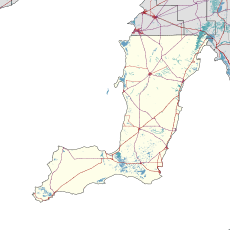
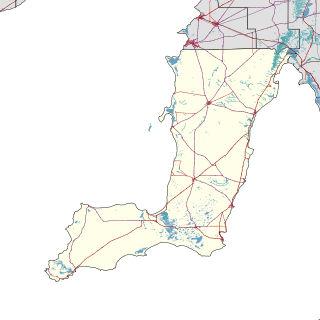
The Yorke Peninsula Council is a local government area in South Australia. Its boundaries include most of the Yorke Peninsula. The council seat is at Maitland; the council also maintains branch offices at Minlaton, Warooka and Yorketown.
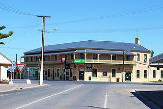
Yorketown is a town and a locality in the Australian state of South Australia located in the southern Yorke Peninsula about 91 kilometres (57 mi) west of the state capital of Adelaide and about 70 kilometres (43 mi) south of the municipal seat of Maitland. At the 2016 census, the locality had a population of 969 of which 642 lived in its town centre.
Balgowan is a small coastal town on the west coast of South Australia's Yorke Peninsula. It is located approximately 20 kilometres west of Maitland. Like other towns on popular with tourists on Yorke Peninsula, it has a large number of shacks, holiday houses, caravan facilities and a boat ramp. The population generally increases during peak holiday periods.

Coobowie is a town in the Australian state of South Australia near the south-eastern tip of Yorke Peninsula. Coobowie was proclaimed in 1875. Coobowie comes from an Aboriginal word meaning "wild fowl water". At the 2011 census, Coobowie shared a population of 220 with other localities. Coobowie's current outlook is to create many new features, including a new visitor information pull in being built. The cafe also has a florist.
Corny Point is a locality in the Australian state of South Australia located about 7.5 kilometres to the east of the north-western tip of the Yorke Peninsula. It was named after the nearby headland, Corny Point.

Sultana Point is a locality in the Australian state of South Australia located on the Yorke Peninsula immediately adjoining the western head of Gulf St Vincent about 80 kilometres west of the state capital of Adelaide.
Agery is a locality in the Australian state of South Australia located on Yorke Peninsula. It is situated 17 km south-east of Moonta. Its name comes from the Aboriginal word ngadjali meaning "pipe clay".
Kainton is a small town in the Australian state of South Australia situated about 10 km south of Paskeville in the upper Yorke Peninsula.
Sunnyvale or Sunny Vale is a locality and former small town in the Australian state of South Australia situated about 10 km south west of Kainton in the upper Yorke Peninsula, consisting mostly of a schoolhouse and Methodist church. Farms nearby were owned by the Lamshed families.
Port Arthur is a locality in the Australian state of South Australia located on the Yorke Peninsula at the northern end of Gulf St Vincent about 100 kilometres north west of the state capital of Adelaide and about 9 kilometres north of the town of Port Wakefield.
Winulta was a town in the Australian state of South Australia on northern Yorke Peninsula around 10 km from Clinton on the Clinton-Maitland road. It was first settled for farming around 1876. The earliest farmers were William Short, Thomas Kenny and John Sharrad.

Hardwicke Bay is a locality in the Australian state of South Australia located on the west coast of Yorke Peninsula overlooking the bay also named Hardwicke Bay about 104 kilometres west of the Adelaide city centre and about 9 kilometres north of the town of Warooka.
Foul Bay is a locality in the Australian state of South Australia located on the south coast of Yorke Peninsula immediately adjoining Investigator Strait about 130 kilometres west of the state capital of Adelaide.

Dowlingville is a locality in the Australian state of South Australia located on the east coast of Yorke Peninsula immediately adjoining Gulf St Vincent about 89 kilometres north-west of the state capital of Adelaide. Its boundaries were created in May 1999.
Nalyappa is a locality in the Australian state of South Australia located on the west coast of Yorke Peninsula immediately adjoining Spencer Gulf about 128 kilometres north-west of the state capital of Adelaide.
Chinaman Wells is a locality in the Australian state of South Australia located on the west coast of Yorke Peninsula immediately adjoining Spencer Gulf about 119 kilometres north-west of the state capital of Adelaide.
Couch Beach is a locality in the Australian state of South Australia located on the western side of Yorke Peninsula on the portion forming the south coast of Hardwicke Bay in Spencer Gulf about 130 kilometres west of the state capital of Adelaide.
Black Point is a locality in the Australian state of South Australia located on the east coast of Yorke Peninsula about 72 kilometres northwest of the state capital of Adelaide.
Bluff Beach is a locality in the Australian state of South Australia located on the west coast of Yorke Peninsula overlooking Hardwicke Bay about 104 kilometres west of the state capital of Adelaide. Farms near by were owned by Edwards families, who were also key pioneers in the development of Bluff Beach.
Clinton Centre is a locality in the Australian state of South Australia located on the northern end of Yorke Peninsula about 99 kilometres north-west of the state capital of Adelaide and about 27 kilometres north-east of the municipal seat in Maitland.