
Newtonville is one of the thirteen villages within the city of Newton in Middlesex County, Massachusetts, United States.

The Center Village District encompasses the historic village center of Lancaster, Massachusetts. Settled in 1643, it has few traces of its early history, but is now a well-kept rural town center with a predominantly residential and civic character. It includes the First Church of Christ, Lancaster, which is a U.S. National Historic Landmark, and was listed on the National Register of Historic Places in 1977.

The Acushnet Heights Historic District is a predominantly residential historic district in central New Bedford, Massachusetts. It encompasses a densely-built urban area about 20 acres (8.1 ha) in size, which was developed as a working-class area, beginning in the 1860s, for the many workers in the city's factories. The district was listed on the National Register of Historic Places in 1989. It abuts the North Bedford Historic District, which is just to the south, and includes the following separately-listed properties: the Union Street Railway Carbarn, the Bradford Smith Building, and the Dawson Building.

The Sutton Center Historic District is a historic district encompassing the center of the village of Sutton, Massachusetts. The district, which covers 435 acres (176 ha), is centered on the junction of Boston Road, Singletary Avenue, and Uxbridge Road. Boston Road is a major east–west route through the town, and the other two roads run north–south through the village center. The Colombian building was built in 1957. A typically rural village center, its civic and institutional buildings are clustered near the intersection on its south side, in the general area of the town common. The town common and cemetery were laid out in 1719, after settlement of the township began in 1716. There are a few surviving houses that date to the middle of the 18th century or earlier; exact dates for most are uncertain. There are only a few institutional buildings: the 1829 Congregational Church, the 1983 Town Hall, built on the site of the town's first purpose-built town hall (1885), and Rufus Putnam Hall, an 1824 school building and Masonic lodge that now houses the local history museum. Only one commercial structure the 1839 Brick Block, stands in the village. There is also a historic animal pound, a rectangular stone structure used to pen stray livestock, which dates to the early days of the town.

The Millis Center Historic District is an historic district on Curve, Daniels, Exchange, Irving, Lavender, Main, and Union Streets in Millis, Massachusetts. It encompasses the historic mid-to-late-19th century village center of the town, including the residential area north of Main Street, two 19th-century industrial complexes, and civic and institutional buildings. It was added to the National Register of Historic Places in 2007.

The East Main–High Street Historic District is a historic district roughly bounded by Church, High, East Main and Franklin Streets in Greenfield, Massachusetts. It encompasses a predominantly residential area just east of Greenfield's central business district, historically where the town's wealthier residents lived, and features a wide variety of mainly 19th-century residential architecture. The district was listed on the National Register of Historic Places in 1989.
The Northfield Main Street Historic District is a historic district located along the full length of Main Street from Millers Brook to Pauchaug Brook in Northfield, Massachusetts. The district encompasses the part of Main Street that was laid out when Northfield was first established in the 17th century. The area has retained many of its traditional lot divisions, and features civic and residential construction from the 18th to the 20th centuries. The district was listed on the National Register of Historic Places in 1982.

The Longmeadow Street–North Historic District encompasses a stretch of Longmeadow Street in northern Longmeadow, Massachusetts, from the town line with neighboring Springfield to Cooley and Westmoreland Streets in the south. It was listed on the National Register of Historic Places in 1994. The district's primarily residential architecture and streetscape is reflective of more than two centuries of development trends, and a late 19th-century desire to maintain a more rural atmosphere.

The Granville Village Historic District is a historic district encompassing the historic Granville Village area in eastern Granville, Massachusetts. The area was developed in the 19th century as an industrial village, centered on the drum factory of Noble & Cooley on Dickinson Brook. The predominantly residential district includes a number of Greek Revival houses; it also includes the Colonial Revival public library building. It is located roughly in the area around the junction of Maple St. and Main and Granby Rds., including part of Water Street. The district was listed on the National Register of Historic Places in 1991.

The Bridge Street Neck Historic District is a predominantly residential historic district in Salem, Massachusetts. It encompasses most of a peninsula of land northeast of downtown Salem, on the route connecting Salem to Beverly, which has been the scene of residential, commercial, and industrial development since the early settlement of Salem in the 1630s. Bridge Street, the spine of the district is a thoroughfare connecting Salem to the bridge leading to Beverly. The district is roughly bounded by railroad tracks to its west, the shore of the peninsula to the east, On the north it is bounded by modern (post-1952) developments, and on the south it abuts the Salem Common Historic District. In addition to properties on Bridge Street, the district includes properties on side streets between March/Osgood Streets, and Howard/Webb Streets. It was listed on the National Register of Historic Places in 2002.

The Newburyport Historic District encompasses most of the historic downtown area of Newburyport, Massachusetts. It is roughly bounded by the Merrimack River, Marlboro Street, Ashland Street and High Streets. Covering some 750 acres (300 ha) of land and more than 2,500 contributing buildings, it includes the most populous part of the city, and a panoply of architectural styles, dating from the 17th century to the early 20th century. The district was added to the National Register of Historic Places in 1984.

The Wayland Center Historic District encompasses the predominantly 19th-century village center of Wayland, Massachusetts. Located at the junction of United States Route 20 and Cochituate Road, it includes fifteen well-preserved 19th-century buildings that form one of the best-preserved village centers of that period near Boston. It was added to the National Register of Historic Places in 1974.

The Kendal Green Historic District is a rural residential district running along North Avenue in Weston, Massachusetts. It extends for about three-quarters of a mile, and includes elements representative of the development of Weston from a rural agricultural community to a residential suburb of Boston. In addition to a variety of predominantly residential and agricultural properties, it includes two formerly industrial sites important in Weston's history: the site of the Hobbs Tannery, and that of the Hook and Hastings Organ Factory. The district was listed on the National Register of Historic Places in 2000.

The Perry Avenue Historic District is a historic district in Worcester, Massachusetts. It includes four well-preserved triple-decker houses that were built in the late 1920s at the base of Vernon Hill, representing one of the last phases of development in that area. The district was listed on the National Register of Historic Places in 1990.

The West Ward School is a historic school at 39 Prospect Street in Wakefield, Massachusetts. Built in 1847, it is the only surviving Greek Revival schoolhouse in the town. The building was listed on the National Register of Historic Places in 1989. It is now maintained by the local historical society as a museum property.
The Fourth Ward Historic District encompasses an early urban residential subdivision of Greenwich, Connecticut. Extending north from United States Route 1 along Sherwood Place, Church Street, and adjacent streets, it is one of two subdivisions created before the arrival of the railroad in Greenwich in 1848. It is characterized by dense residential construction, with architectural styles from the Greek Revival to early 20th-century styles. The district was listed on the National Register of Historic Places in 2000.
The Kings Highway North Historic District is a predominantly residential 58-acre (23 ha) historic district in Westport, Connecticut. Located on the hillside west of the Saugatuck River, this area encapsulates architecturally several major stages in the community's development, from colonial days to the 20th century. It was listed on the National Register of Historic Places in 1998.

The West Chesterfield Historic District is a historic district that encompasses the 19th century industrial and residential heritage of the village of West Chesterfield in the town of Chesterfield, Massachusetts. Centered at the junction of Main Road and Ireland Street, it was one of the town's main industrial sites for many years. The district was listed on the National Register of Historic Places in 2008.

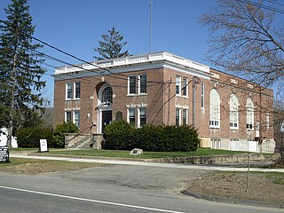
The Community House at 284 Bay Road in Hamilton, Massachusetts is a historic social and civic community building serving the towns of Hamilton and Wenham. The Colonial Revival brick building was built in 1921 to a design by noted Boston architect Guy Lowell, and was listed on the National Register of Historic Places in 2011.

The Town Center Historic District encompasses the historic village center of South Hampton, New Hampshire. Centered around the Barnard Green, the town common, on New Hampshire Route 107A, it includes architectural reminders of the town's growth and change over time. The district was listed on the National Register of Historic Places in 1983.


