West Lake Stevens, Washington

Last updated
West Lake Stevens, Washington
former CDP
Snohomish County Washington Incorporated and Unincorporated areas West Lake Stevens Highlighted.svg
Location of West Lake Stevens, Washington
Coordinates: 47°59′45″N122°6′7″W / 47.99583°N 122.10194°W / 47.99583; -122.10194 Coordinates: 47°59′45″N122°6′7″W / 47.99583°N 122.10194°W / 47.99583; -122.10194
CountryUnited States
State Washington
County Snohomish
Area
  Total11.3 sq mi (29.2 km2)
  Land9.7 sq mi (25.1 km2)
  Water1.6 sq mi (4.1 km2)
Elevation
367 ft (112 m)
Population
 (2000)
  Total18,071
  Density1,866.5/sq mi (720.7/km2)
Time zone UTC-8 (Pacific (PST))
  Summer (DST) UTC-7 (PDT)
FIPS code 53-77542 [1]
GNIS feature ID1867643 [2]

West Lake Stevens is a former census-designated place (CDP) in Snohomish County, Washington, United States. The population was 18,071 at the 2000 census.

Contents

Much of West Lake Stevens was annexed into the City of Lake Stevens through a community-driven effort called "One Community Around the Lake" that began in 2006. The remaining parts were taken to form the new CDPs of Bunk Foss and Cavalero in 2010. [3]

Geography

West Lake Stevens is located at 47°59′45″N122°6′7″W / 47.99583°N 122.10194°W / 47.99583; -122.10194 (47.995925, -122.101815). [4]

According to the United States Census Bureau, the CDP had a total area of 11.3 square miles (29.2 km2), of which, 9.7 square miles (25.1 km2) of it is land and 1.6 square miles (4.1 km2) of it (14.11%) is water.

Demographics

As of the census [1] of 2000, there were 18,071 people, 6,255 households, and 4,828 families residing in the CDP. The population density was 1,866.5 people per square mile (720.8/km2). There were 6,504 housing units at an average density of 671.8/sq mi (259.4/km2). The racial makeup of the CDP was 91.01% White, 1.03% African American, 0.84% Native American, 1.96% Asian, 0.17% Pacific Islander, 1.74% from other races, and 3.25% from two or more races. Hispanic or Latino of any race were 4.39% of the population.

There were 6,255 households, out of which 47.0% had children under the age of 18 living with them, 61.2% were married couples living together, 11.0% had a female householder with no husband present, and 22.8% were non-families. 16.4% of all households were made up of individuals, and 4.3% had someone living alone who was 65 years of age or older. The average household size was 2.89 and the average family size was 3.23.

In the CDP, the age distribution of the population shows 32.3% under the age of 18, 7.1% from 18 to 24, 36.6% from 25 to 44, 17.7% from 45 to 64, and 6.3% who were 65 years of age or older. The median age was 31 years. For every 100 females, there were 99.6 males. For every 100 females age 18 and over, there were 98.7 males.

The median income for a household in the CDP was $57,331, and the median income for a family was $60,258. Males had a median income of $45,648 versus $31,061 for females. The per capita income for the CDP was $22,281. About 4.4% of families and 5.3% of the population were below the poverty line, including 5.5% of those under age 18 and 7.0% of those age 65 or over.

Related Research Articles

Lake of the Woods, Illinois Census-designated place in Illinois, United States

Lake of the Woods is a census-designated place (CDP) in Champaign County, Illinois, United States. The population was 2,912 at the 2010 census. Lake of the Woods is in Mahomet Township and mostly surrounded by the northeast part of the village of Mahomet.

Ames Lake, Washington Census-designated place in Washington, United States

Ames Lake is an unincorporated community and census-designated place (CDP) in King County, Washington, United States. The population was 1,486 at the 2010 census.

Baring, Washington Census-designated place in Washington, United States

Baring is an unincorporated community and census-designated place (CDP) in King County, Washington, United States. The population was 220 at the 2010 census. It is located on U.S. Highway 2 about 23 miles (37 km) west of Stevens Pass, along a very flat and straight three-mile section of highway that has been dubbed the "Baring Straight", since US-2 is otherwise hilly and curvy through the mountains.

Cottage Lake, Washington Census-designated place in Washington, United States

Cottage Lake is a census-designated place (CDP) in King County, Washington, United States. The population was 22,494 at the 2010 census. The lake itself falls within the 98072 ZIP code, while the developments east of the lake fall under the 98077 ZIP code.

Lake Marcel-Stillwater, Washington Census-designated place in Washington, United States

Lake Marcel-Stillwater is a census-designated place (CDP) in King County, Washington, United States. The population was 1,277 at the 2010 census.

Lake Morton-Berrydale, Washington Census-designated place in Washington, United States

Lake Morton-Berrydale is a census-designated place (CDP) in King County, Washington, United States. The population was 10,160 at the 2010 census.

Lakeland North, Washington Census-designated place in Washington, United States

Lakeland North is a census-designated place (CDP) in King County, Washington, United States. The population was 12,942 at the 2010 census. Part of the community was annexed into neighboring Auburn in 2008.

Maple Heights-Lake Desire, Washington Census-designated place in Washington, United States

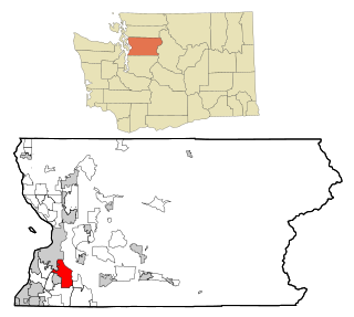
Maple Heights-Lake Desire is a census-designated place (CDP) in King County, Washington, United States. At the 2010 census, the population was 3,152.

Union Hill-Novelty Hill, Washington Census-designated place in Washington, United States

Union Hill-Novelty Hill is a census-designated place (CDP) in King County, Washington, United States. The area was first recognized by the Census Bureau in the 2000 census. The population was 18,805 at the 2010 census.

West Lake Sammamish, Bellevue, Washington Neighborhood in King, Washington, United States

West Lake Sammamish was a census-designated place (CDP) in King County, Washington, United States. The population was 5,937 at the 2000 census. The census area was annexed by Bellevue in 2001.

Erlands Point-Kitsap Lake, Washington CDP in Washington, United States

Erland's Point-Kitsap Lake is a census-designated place (CDP) in Kitsap County, Washington, United States. The population was 2,935 at the 2010 census.

Parkwood, Washington CDP in Washington, United States

Parkwood is a census-designated place (CDP) in Kitsap County, Washington, United States. The population was 7,126 at the 2010 census.

Prairie Ridge, Washington CDP in Washington, United States

Prairie Ridge is a census-designated place (CDP) in Pierce County, Washington, United States. The population was 11,688 at the 2000 census.

Waller, Washington CDP in Washington, United States

Waller is a census-designated place (CDP) in Pierce County, Washington, United States. The population was 9,200 at the 2000 census.

Lake McMurray, Washington CDP in Washington, United States

Lake McMurray is a census-designated place (CDP) in Skagit County, Washington, United States. The population was 192 at the 2010 census. It is included in the Mount Vernon–Anacortes, Washington Metropolitan Statistical Area.

High Bridge, Washington CDP in Washington, United States

High Bridge is a census-designated place (CDP) in Snohomish County, Washington, United States. The population was 2,994 at the 2010 census. High Bridge includes the Echo Lake community and the former Echo Lake CDP, which was superseded by the larger High Bridge CDP in 2010.

Martha Lake, Washington CDP in Washington, United States

Martha Lake is a census-designated place (CDP) in Snohomish County, Washington, United States. The population was 15,473 at the 2010 census. It lies west of Mill Creek and northeast of Lynnwood, near the lake of the same name.

Lake Stickney, Washington CDP in the United States

Lake Stickney is a census-designated place (CDP) in Snohomish County, Washington, United States. The population was 7,777 at the 2010 census. The CDP was known as Paine Field-Lake Stickney prior to 2010. The new Lake Stickney CDP no longer contains the Paine Field airport.

Silver Firs, Washington CDP in Washington, United States

Silver Firs is a census-designated place (CDP) in Snohomish County, Washington, United States. The population was 20,891 at the 2010 census. It lies northeast of the city of Mill Creek. Silver Firs is one of two CDPs that were created out of the former Seattle Hill-Silver Firs CDP in 2010, the other being Eastmont.

Bangor Base, Washington Census-designated place in Washington, United States

Bangor Base is a census-designated place (CDP) in Kitsap County, Washington, within U.S. Naval Base Kitsap on the Kitsap Peninsula. Its population was 6,054 at the 2010 census.

References

  1. 1 2 "U.S. Census website". United States Census Bureau . Retrieved 2008-01-31.
  2. "US Board on Geographic Names". United States Geological Survey. 2007-10-25. Retrieved 2008-01-31.
  3. "Washington: 2010 Population and Housing Unit Counts" (PDF). United States Census Bureau. Retrieved 3 March 2013.
  4. "US Gazetteer files: 2010, 2000, and 1990". United States Census Bureau. 2011-02-12. Retrieved 2011-04-23.