
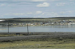
Rankin Inlet is an Inuit hamlet on the Kudlulik Peninsula in Nunavut, Canada. It is the largest hamlet and second-largest settlement in Nunavut, after the territorial capital, Iqaluit. On the northwestern Hudson Bay, between Chesterfield Inlet and Arviat, it is the regional centre for the Kivalliq Region.

Arviat is a predominantly Inuit hamlet located on the western shore of Hudson Bay in the Kivalliq Region of Nunavut, Canada. Arviat is derived from the Inuktitut word arviq meaning "Bowhead whale". Earlier in history, its name was Tikirajualaaq, and Ittaliurvik,.
In Canada, National Airport System is a group of major airports defined in the National Airports Policy published in 1994. It was intended to include all airports with an annual traffic of 200,000 passengers or more, as well as airports serving the national, provincial and territorial capitals.
Baker Lake is a hamlet in the Kivalliq Region, in Nunavut on mainland Canada. Located 320 km (200 mi) inland from Hudson Bay, it is near the nation's geographical centre, and is notable for being Nunavut's sole inland community. The hamlet is located at the mouth of the Thelon River on the shore of Baker Lake. The community was given its English name in 1761 from Captain William Christopher who named it after Sir William Baker, the 11th Governor of the Hudson's Bay Company.

Arviat Airport is located at Arviat, Nunavut, Canada, and is operated by the government of Nunavut. Local taxis provide service between the hamlet and the airport for $7.

Clyde River Airport is located 2.2 nautical miles northeast of Clyde River, Nunavut, Canada, and is operated by the government of Nunavut.

Coral Harbour Airport is located 6 nautical miles northwest of Coral Harbour, Nunavut, Canada, and is operated by the government of Nunavut.It has a GRVL runway 5006 x 100 feet.

Kugaaruk Airport, formerly known as Pelly Bay Townsite Airport, is located at Kugaaruk in Nunavut, Canada. It is operated by the government of Nunavut.

Kugluktuk Airport is located at Kugluktuk, Nunavut, Canada, and is operated by the Government of Nunavut.

Rankin Inlet Airport is located at Rankin Inlet, Nunavut, Canada, and is operated by the government of Nunavut.
Chesterfield Inlet Airport is located 1 nautical mile northwest of Chesterfield Inlet, Nunavut, Canada, and is operated by the government of Nunavut.

Grise Fiord Airport is located in Grise Fiord, Nunavut, Canada, and is operated by the Government of Nunavut. The only building at this airport is the Air Passenger Shelter and the companies that operate there are Air Nunavut using the Super King Air 200 and Kenn Borek Air using the DHC-6 Twin Otter planes. Flights to this airport are usually from Resolute Bay Airport and most of them only carry cargo with few to no passengers.

Igloolik Airport is located at Igloolik, Nunavut, Canada, and is operated by the government of Nunavut.
Pangnirtung Airport is located at Pangnirtung, Nunavut, Canada, and is operated by the Government of Nunavut.
Qikiqtarjuaq is a community located on Broughton Island in the Qikiqtaaluk Region of Nunavut, Canada. The island is known for Arctic wildlife, bird watching at the Qaqulluit National Wildlife Area. The community serves as the northern access point for Auyuittuq National Park and Pangnirtung is the southern access point.

Calm Air International LP. is a full service airline, offering passenger, charter and freight services in northern Manitoba and the Kivalliq Region of Nunavut. It is owned by Exchange Income Corporation with its main base in Winnipeg, Manitoba.

Whale Cove, is a hamlet located 74 km (46 mi) south southwest of Rankin Inlet, 145 km (90 mi) northeast of Arviat, in the Kivalliq Region, Nunavut, Canada, on the western shore of Hudson Bay.

Coral Harbour is a small Inuit community that is located on Southampton Island, Kivalliq Region, in the Canadian territory of Nunavut. Its name is derived from the fossilized coral that can be found around the waters of the community which is situated at the head of South Bay. The name of the settlement in Inuktitut is Salliq, sometimes used to refer to all of Southampton Island. The plural Salliit, means large flat island(s) in front of the mainland.

Kugaaruk, formerly known as Pelly Bay until 3 December 1999, is located on the shore of Pelly Bay, just off the Gulf of Boothia, Simpson Peninsula, Kitikmeot, in Canada's Nunavut territory. Access is by air by the Kugaaruk Airport, by annual supply sealift, and by sea ice. Kugaaruk means "little stream", the traditional name of the brook that flows through the hamlet.


