
Geelong Airport was a small airfield specifically for light aircraft located in Mount Duneed, Victoria, Australia. It was primarily used for scenic flights and private aircraft, and was located in the local government area of the City of Greater Geelong.
Mount Duneed is a suburb of Geelong, Victoria, Australia. It is divided between the City of Greater Geelong and Surf Coast Shire local government areas. Mount Duneed itself is an extinct volcano and the remains of the crater can be seen in the Mount Duneed Recreation Reserve.

Kingsgrove is a suburb in Southern Sydney, New South Wales, Australia. Kingsgrove is 13 kilometres (8.1 mi) south-west of the Sydney central business district and lies across the local government areas of the City of Canterbury-Bankstown, Bayside Council and the Georges River Council.

Luddenham is a suburb of Sydney, in the state of New South Wales, Australia 42 kilometres west of the Sydney central business district, in the local government areas of the City of Penrith and City of Liverpool. It is part of the Greater Western Sydney region.

Tennant Creek Airport is a small regional airport located near Tennant Creek, Northern Territory, Australia.
Crooked Creek Airport is a public airport located two miles (3 km) south of the central business district of Crooked Creek, in the U.S. state of Alaska.
Hooker Creek Airport, also known as Hooker Creek Aerodrome and Lajamanu Airport, is an airport in Lajamanu, Northern Territory, Australia. The airstrip is sealed.
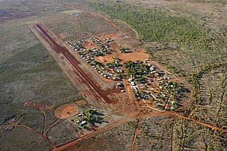
Julia Creek Airport is an airport in Julia Creek, Queensland, Australia.
Halls Creek Airport is a regional airport in Western Australia's Kimberley region. It is located in Halls Creek, which is approximately 2,524 km (1,568 mi) from Perth, Western Australia.

The Patawalonga River is a river located in the western suburbs of the Adelaide metropolitan area, in the Australian state of South Australia. It drains an area of flat, swampy lands formerly known as the Cowandilla Plains or The Reedbeds, which in the mid-20th century were drained by engineering works, enabling the establishment of Adelaide Airport and the development of residential housing.
Fleurs Aerodrome was a parent aerodrome built on behalf of the Royal Australian Air Force during World War II. It is located at Kemps Creek 40 km west of Sydney, Australia
Christmas Creek Airport is an airport serving Christmas Creek Station, in the Australian state of Western Australia.
Yankee Creek Airport, also known as Yankee Creek 2 Airport, is a privately owned public-use airport located one nautical mile south of the central business district of Yankee Creek, in the Yukon-Koyukuk Census Area of the U.S. state of Alaska.

South West Queensland is a remote region in the Australian state of Queensland which covers 319,808 km2 (123,479 sq mi). The region lies to the south of Central West Queensland and west of the Darling Downs and includes the Maranoa district and parts of the Channel Country. The area is noted for its cattle grazing, cotton farming, opal mining and oil and gas deposits.
Leigh Creek Airport is located 1 nautical mile east of the town centre in the locality of Leigh Creek, South Australia.
Badgerys Creek, a watercourse that is part of the Hawkesbury-Nepean catchment, is located in Greater Western Sydney, New South Wales, Australia.
Gore Creek, an urban watercourse that is part of the Parramatta River catchment, is located in Northern Suburbs region of Sydney, Australia.
Scott Creek is a locality in the Adelaide Hills about 24 kilometres (15 mi) southeast of Adelaide in South Australia. It includes the "ceased Government Town" of Cotton.
Punchs Creek is a rural locality in the Toowoomba Region, Queensland, Australia. In the 2016 census Punchs Creek had a population of 43 people.
