Wilsonville, Nebraska

Last updated

Wilsonville, Nebraska
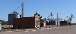
Wilsonville, Nebraska downtown 2.JPG
Downtown Wilsonville
Furnas County Nebraska Incorporated and Unincorporated areas Wilsonville Highlighted.svg
Location of Wilsonville, Nebraska
Coordinates: 40°06′43″N100°06′24″W / 40.11194°N 100.10667°W / 40.11194; -100.10667
Country United States
State Nebraska
County Furnas
Area
[1]
  Total0.27 sq mi (0.69 km2)
  Land0.27 sq mi (0.69 km2)
  Water0.00 sq mi (0.00 km2)
Elevation
[2]
2,300 ft (700 m)
Population
 (2020)
  Total75
  Density280.90/sq mi (108.47/km2)
Time zone UTC-6 (Central (CST))
  Summer (DST) UTC-5 (CDT)
ZIP code
69046
Area code 308
FIPS code 31-53240 [3]
GNIS feature ID2399710 [2]

Wilsonville is a village in Furnas County, Nebraska, United States. The population was 93 at the 2010 census.

Contents

History

Wilsonville was first settled in 1872 under the name “Wild Turkey”. A post office was established on April 18 of 1873. [4] On December 16, 1873, the name was officially changed from Wild Turkey to Wilsonville [5] in honor of L.M. and Carlos Wilson, two brothers that were merchants and stockman. [6]

Geography

According to the United States Census Bureau, the village has a total area of 0.27 square miles (0.70 km2), all land. [7]

Demographics

Historical population
CensusPop.Note
1900 296
1910 38530.1%
1920 47022.1%
1930 4894.0%
1940 382−21.9%
1950 327−14.4%
1960 289−11.6%
1970 266−8.0%
1980 189−28.9%
1990 136−28.0%
2000 118−13.2%
2010 93−21.2%
2020 75−19.4%
U.S. Decennial Census [8]

2010 census

As of the census [9] of 2010, there were 93 people, 45 households, and 31 families residing in the village. The population density was 344.4 inhabitants per square mile (133.0/km2). There were 83 housing units at an average density of 307.4 per square mile (118.7/km2). The racial makeup of the village was 96.8% White, 1.1% Native American, 1.1% Asian, and 1.1% from two or more races. Hispanic or Latino of any race were 2.2% of the population.

There were 45 households, of which 20.0% had children under the age of 18 living with them, 68.9% were married couples living together, and 31.1% were non-families. 31.1% of all households were made up of individuals, and 8.9% had someone living alone who was 65 years of age or older. The average household size was 2.07 and the average family size was 2.55.

The median age in the village was 54.1 years. 17.2% of residents were under the age of 18; 1.2% were between the ages of 18 and 24; 15% were from 25 to 44; 43% were from 45 to 64; and 23.7% were 65 years of age or older. The gender makeup of the village was 50.5% male and 49.5% female.

2000 census

As of the census [3] of 2000, there were 118 people, 57 households, and 34 families residing in the village. The population density was 440.1 inhabitants per square mile (169.9/km2). There were 91 housing units at an average density of 339.4 per square mile (131.0/km2). The racial makeup of the village was 97.46% White, 0.85% Native American, 1.69% from other races. Hispanic or Latino of any race were 1.69% of the population.

There were 57 households, out of which 22.8% had children under the age of 18 living with them, 54.4% were married couples living together, 7.0% had a female householder with no husband present, and 38.6% were non-families. 36.8% of all households were made up of individuals, and 14.0% had someone living alone who was 65 years of age or older. The average household size was 2.07 and the average family size was 2.69.

In the village, the population was spread out, with 22.0% under the age of 18, 2.5% from 18 to 24, 23.7% from 25 to 44, 35.6% from 45 to 64, and 16.1% who were 65 years of age or older. The median age was 47 years. For every 100 females, there were 110.7 males. For every 100 females age 18 and over, there were 104.4 males.

As of 2000 the median income for a household in the village was $32,500, and the median income for a family was $37,500. Males had a median income of $26,875 versus $22,917 for females. The per capita income for the village was $17,863. There were 5.6% of families and 6.7% of the population living below the poverty line, including 5.0% of under eighteens and none of those over 64.
Notable person

Related Research Articles

<span class="mw-page-title-main">Furnas County, Nebraska</span> County in Nebraska, United States

Furnas County is a county in the U.S. state of Nebraska. As of the 2020 United States Census, the population was 4,636. Its county seat is Beaver City. The county was named for Robert Wilkinson Furnas, the second governor of the state of Nebraska.

<span class="mw-page-title-main">Mount Clare, Illinois</span> Village in Illinois, United States

Mount Clare is a village in Macoupin County, Illinois, United States. Its population was 311 at the 2020 census.

<span class="mw-page-title-main">Wilsonville, Illinois</span> Village in Illinois, United States

Wilsonville is a village in Macoupin County, Illinois, United States. The population was 536 at the 2020 census.

<span class="mw-page-title-main">Greenwood, Nebraska</span> Village in Nebraska, United States

Greenwood is a village in northwest Cass County, Nebraska, United States. The population was 595 at the 2020 census.

<span class="mw-page-title-main">Nenzel, Nebraska</span> Village in Cherry County, Nebraska, United States

Nenzel is a village in Cherry County, Nebraska, United States. The population was 20 at the 2010 census.

<span class="mw-page-title-main">Anselmo, Nebraska</span> Village in Nebraska, United States

Anselmo is a village in Custer County, Nebraska, United States. The population was 145 at the 2010 census.

<span class="mw-page-title-main">Boys Town, Nebraska</span> Village in Douglas County, Nebraska, United States

Boys Town is a village in Douglas County, Nebraska, United States. The population was 410 at the 2020 census. Boys Town is an enclave and a suburb of Omaha.

<span class="mw-page-title-main">Waterloo, Nebraska</span> Village in Douglas County, Nebraska, United States

Waterloo is a village in Douglas County, Nebraska, United States. The population was 935 at the 2020 census.

<span class="mw-page-title-main">Beaver City, Nebraska</span> City in Nebraska, United States

Beaver City is a city in Furnas County, on the southern border of Nebraska, United States. The population was 609 at the 2010 census. It is the county seat of Furnas County.

<span class="mw-page-title-main">Edison, Nebraska</span> Village in Nebraska, United States

Edison is a village in Furnas County, Nebraska, United States. The population was 133 at the 2010 census.

<span class="mw-page-title-main">Hendley, Nebraska</span> Village in Furas County, Nebraska, United States

Hendley is a village in Furnas County, Nebraska, United States. The population was 24 at the 2010 census.

<span class="mw-page-title-main">Holbrook, Nebraska</span> Village in Nebraska, United States

Holbrook is a village in Furnas County, Nebraska, United States. The population was 207 at the 2010 census.

<span class="mw-page-title-main">Wolbach, Nebraska</span> Village in Greeley County, Nebraska, United States

Wolbach is a village in Greeley county, Nebraska, United States. The population was 283 at the time of the 2010 census.

<span class="mw-page-title-main">Orleans, Nebraska</span> Village in Nebraska, United States

Orleans is a village in Harlan County, Nebraska, United States. The population was 386 at the 2010 census.

<span class="mw-page-title-main">Page, Nebraska</span> Village in Holt County, Nebraska, United States

Page is a village in Holt County, Nebraska, United States. The population was 166 at the 2010 census.

<span class="mw-page-title-main">Taylor, Nebraska</span> Village in Nebraska, United States

Taylor is a village in, and the county seat of, Loup County, Nebraska, United States. The population was 190 at the 2010 census.

<span class="mw-page-title-main">Ceresco, Nebraska</span> Village in Saunders County, Nebraska, United States

Ceresco is a farming village in Saunders County, Nebraska, United States. The population was 919 at the 2020 census. It is located near U.S. Highway 77, just north of Lincoln, just south of Wahoo, and a short distance southwest of Omaha.

<span class="mw-page-title-main">Morse Bluff, Nebraska</span> Village in Saunders County, Nebraska, United States

Morse Bluff is a village in Saunders County, Nebraska, United States. The population was 117 at the 2020 census.

<span class="mw-page-title-main">Valparaiso, Nebraska</span> Village in Saunders County, Nebraska, United States

Valparaiso is a village in Saunders County, Nebraska, United States. The population was 595 at the 2020 census.

<span class="mw-page-title-main">Oxford, Nebraska</span> Village in Nebraska, United States

Oxford is a village in Furnas and Harlan counties in the U.S. state of Nebraska. The population was 779 at the 2010 census.

References

  1. "ArcGIS REST Services Directory". United States Census Bureau. Retrieved September 18, 2022.
  2. 1 2 U.S. Geological Survey Geographic Names Information System: Wilsonville, Nebraska
  3. 1 2 "U.S. Census website". United States Census Bureau . Retrieved January 31, 2008.
  4. Burr, George L. (1921). History of Hamilton and Clay Counties, Nebraska, Volume 1. S.J. Clarke Publishing Company. p. 111.
  5. "Furnas County Resources and Records Page". www.swngs.org. Retrieved February 26, 2021.
  6. "CASDE | Wilsonville -- Furnas County". casde.unl.edu. Retrieved February 26, 2021.
  7. "US Gazetteer files 2010". United States Census Bureau . Retrieved June 24, 2012.
  8. "Census of Population and Housing". Census.gov. Retrieved June 4, 2015.
  9. "U.S. Census website". United States Census Bureau . Retrieved June 24, 2012.