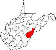
Woodrow, Pocahontas County, West Virginia

Last updated
Woodrow, West Virginia
Unincorporated community
USA West Virginia location map.svg
Red pog.svg
Woodrow, West Virginia
Usa edcp location map.svg
Red pog.svg
Woodrow, West Virginia
Coordinates: 38°16′52″N80°09′30″W / 38.28111°N 80.15833°W / 38.28111; -80.15833 Coordinates: 38°16′52″N80°09′30″W / 38.28111°N 80.15833°W / 38.28111; -80.15833
Country United States
State West Virginia
County Pocahontas
Elevation 3,212 ft (979 m)
Time zone Eastern (EST) (UTC-5)
  Summer (DST) EDT (UTC-4)
Area code(s) 304 & 681
GNIS feature ID 1553515 [1]

Woodrow is an unincorporated community in Pocahontas County, West Virginia, United States. Woodrow is 5.5 miles (8.9 km) northwest of Marlinton.

Unincorporated area Region of land not governed by own local government

In law, an unincorporated area is a region of land that is not governed by a local municipal corporation; similarly an unincorporated community is a settlement that is not governed by its own local municipal corporation, but rather is administered as part of larger administrative divisions, such as a township, parish, borough, county, city, canton, state, province or country. Occasionally, municipalities dissolve or disincorporate, which may happen if they become fiscally insolvent, and services become the responsibility of a higher administration. Widespread unincorporated communities and areas are a distinguishing feature of the United States and Canada. In most other countries of the world, there are either no unincorporated areas at all, or these are very rare; typically remote, outlying, sparsely populated or uninhabited areas.

Pocahontas County, West Virginia county in West Virginia, United States

Pocahontas County is a county located in the U.S. state of West Virginia. As of the 2010 census, the population was 8,719. Its county seat is Marlinton. The county was established in 1821. It is named after the daughter of the Powhatan Native American chief from Jamestown, Virginia. She married an English settler and their mixed-race children became ancestors of many of the First Families of Virginia.

West Virginia State of the United States of America

West Virginia is a state located in the Appalachian region in the Southern United States and is also considered to be a part of the Middle Atlantic States. It is bordered by Pennsylvania to the north, Maryland to the east and northeast, Virginia to the southeast, Kentucky to the southwest, and Ohio to the northwest. West Virginia is the 41st largest state by area, and is ranked 38th in population. The capital and largest city is Charleston.

The community was named after Woodrow Wilson, 28th President of the United States. [2]

Woodrow Wilson 28th President of the United States

Thomas Woodrow Wilson was an American statesman and academic who served as the 28th president of the United States from 1913 to 1921. A member of the Democratic Party, Wilson served as the president of Princeton University and as the 34th governor of New Jersey before winning the 1912 presidential election. As president, he oversaw the passage of progressive legislative policies unparalleled until the New Deal in 1933. He also led the United States during World War I, establishing an activist foreign policy known as "Wilsonianism."

Related Research Articles

Pocahontas, Virginia Town in Virginia, United States

Pocahontas is a town in Tazewell County, Virginia, United States. It was named for Chief Powhatan's daughter, Pocahontas, who lived in the 17th-century Jamestown Settlement. She married John Rolfe, and they were among the ancestors of many of the First Families of Virginia.

Minnehaha Springs, West Virginia Unincorporated community in West Virginia, United States

Minnehaha Springs is an unincorporated community located in Pocahontas County, West Virginia, United States. It was named for the fictional Native American "princess," Minnehaha, and the mineral springs on the Lockridge farm. It is the only community with this name in the United States. On the site of what is now Camp Twin Creeks warm mineral springs can still be found. Jussie's Corner Flea Market is always open for business. "Jussie's Place" is a local historical site to the people of Minnehaha springs. Jussies is a family owned and operated business. Their Post Office has been closed.

Clover Lick, West Virginia Unincorporated community in West Virginia, United States

Clover Lick is an unincorporated community in Pocahontas County, West Virginia, United States. Clover Lick is located along the Greenbrier River 10 miles (16 km) northeast of Marlinton. The community is home to the Clover Lick Train Depot, which sits along the Greenbrier River Trail at Milepost 71.2. Clover Lick was founded in the early 1900s as a place to board trains traveling along the Greenbrier River.

Slaty Fork, West Virginia Unincorporated community in West Virginia, United States

Slaty Fork is an unincorporated community in Pocahontas County, West Virginia, United States. Slaty Fork is located along U.S. Route 219 13.5 miles (21.7 km) north of Marlinton.

Mill Point, West Virginia Unincorporated community in West Virginia, United States

Mill Point is an unincorporated community in Pocahontas County, West Virginia, United States. Mill Point is located at the junction of U.S. Route 219, West Virginia Route 39, and West Virginia Route 55 2.5 miles (4.0 km) northeast of Hillsboro.

Seebert, West Virginia Unincorporated community in West Virginia, United States

Seebert is an unincorporated community in Pocahontas County, West Virginia, United States. Seebert is located on the Greenbrier River 2 miles (3.2 km) east of Hillsboro.

Denmar, West Virginia Unincorporated community in West Virginia, United States

Denmar is an unincorporated community in Pocahontas County, West Virginia, United States. Denmar is 3.5 miles (5.6 km) south-southwest of Hillsboro.

Edray, West Virginia Unincorporated community in West Virginia, United States

Edray is an unincorporated community in Pocahontas County, West Virginia, United States. Edray is located near U.S. Route 219 and West Virginia Route 55 3.5 miles (5.6 km) north of Marlinton. It is home to the Edray State Trout Hatchery.

Hosterman, West Virginia Unincorporated community in West Virginia, United States

Hosterman is an unincorporated community in Pocahontas County, West Virginia, United States. Hosterman is located on the Greenbrier River 5.5 miles (8.9 km) south-southwest of Durbin. The community was originally named Collins; its name was changed to Hosterman in 1902. The community presently has the name of Theodore G. Hosterman, a worker in the local lumber industry.

Jacox, West Virginia Unincorporated community in West Virginia, United States

Jacox is an unincorporated community in Pocahontas County, West Virginia, United States. Jacox is 6 miles (9.7 km) southwest of Hillsboro.

Lobelia, West Virginia Unincorporated community in West Virginia, United States

Lobelia is an unincorporated community in Pocahontas County, West Virginia, United States. Lobelia is 4.5 miles (7.2 km) west of Hillsboro.

Mace, West Virginia Unincorporated community in West Virginia, United States

Mace is an unincorporated community in Pocahontas County, West Virginia, United States. Mace is located on U.S. Route 219 and West Virginia Route 55 16.5 miles (26.6 km) north-northeast of Marlinton.

Onoto, West Virginia Unincorporated community in West Virginia, United States

Onoto is an unincorporated community in Pocahontas County, West Virginia, United States. Onoto is 3.5 miles (5.6 km) north-northwest of Marlinton.

Rimel, West Virginia Unincorporated community in West Virginia, United States

Rimel is an unincorporated community in Pocahontas County, West Virginia, United States. Rimel is located on West Virginia Route 92 10.5 miles (16.9 km) southeast of Marlinton.

Spice, West Virginia Unincorporated community in West Virginia, United States

Spice is an unincorporated community in Pocahontas County, West Virginia, United States. Spice is located on U.S. Route 219 3.5 miles (5.6 km) southwest of Hillsboro.

Watoga, West Virginia Unincorporated community in West Virginia, United States

Watoga is an unincorporated community in Pocahontas County, West Virginia, United States. Watoga is located on the east bank of the Greenbrier River 3.5 miles (5.6 km) east-northeast of Hillsboro.

Wildell, West Virginia Unincorporated community in West Virginia, United States

Wildell is an unincorporated community in Pocahontas County, West Virginia, United States. Wildell is 11.5 miles (18.5 km) north-northeast of Durbin.

Woodrow, West Virginia may refer to:

References