Wortham, Texas | |
---|---|
Coordinates: 31°47′18″N96°27′44″W / 31.78833°N 96.46222°W | |
Country | United States |
State | Texas |
County | Freestone |
Area | |
• Total | 1.99 sq mi (5.15 km2) |
• Land | 1.99 sq mi (5.15 km2) |
• Water | 0.00 sq mi (0.00 km2) |
Elevation | 476 ft (145 m) |
Population (2020) | |
• Total | 980 |
• Density | 501.26/sq mi (193.51/km2) |
Time zone | UTC-6 (Central (CST)) |
• Summer (DST) | UTC-5 (CDT) |
ZIP code | 76693 |
Area code | 254 |
FIPS code | 48-80296 [2] |
GNIS feature ID | 1350596 [3] |
Wortham is a town in Freestone County, Texas, United States. The population was 980 at the 2020 census. [4]
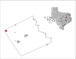
Wortham is located in the northwestern corner of Freestone County at 31°47′18″N96°27′44″W / 31.78833°N 96.46222°W (31.788472, –96.462209). [5] Texas State Highway 14 runs through town as Third Street, leading north 10 miles (16 km) to Richland and Interstate 45, and south 8 miles (13 km) to Mexia. Fairfield, the Freestone County seat, is 18 miles (29 km) to the southeast.
According to the United States Census Bureau, the town has a total area of 2.0 square miles (5.1 km2), all land. [4] Wortham lies near the highest point between Dallas and Houston, the nearby Tehuacana Hills.
Census | Pop. | Note | %± |
---|---|---|---|
1880 | 245 | — | |
1890 | 401 | 63.7% | |
1910 | 899 | — | |
1920 | 1,100 | 22.4% | |
1930 | 1,404 | 27.6% | |
1940 | 1,267 | −9.8% | |
1950 | 1,170 | −7.7% | |
1960 | 1,087 | −7.1% | |
1970 | 1,036 | −4.7% | |
1980 | 1,187 | 14.6% | |
1990 | 1,020 | −14.1% | |
2000 | 1,082 | 6.1% | |
2010 | 1,073 | −0.8% | |
2020 | 980 | −8.7% | |
U.S. Decennial Census [6] |
Race | Number | Percentage |
---|---|---|
White (NH) | 655 | 66.84% |
Black or African American (NH) | 151 | 15.41% |
Native American or Alaska Native (NH) | 5 | 0.51% |
Asian (NH) | 2 | 0.2% |
Pacific Islander (NH) | 1 | 0.1% |
Mixed/Multi-Racial (NH) | 40 | 4.08% |
Hispanic or Latino | 126 | 12.86% |
Total | 980 |
As of the 2020 United States census, there were 980 people, 429 households, and 252 families residing in the town.
As of the census [2] of 2000, there were 1,082 people, 428 households, and 278 families residing in the town. The population density was 545.9 inhabitants per square mile (210.8/km2). There were 479 housing units at an average density of 241.7 per square mile (93.3/km2). The racial makeup of the town was 79.94% White, 17.84% African American, 0.65% Native American, 1.20% from other races, and 0.37% from two or more races. Hispanic or Latino of any race were 2.77% of the population.
There were 428 households, out of which 35.0% had children under the age of 18 living with them, 46.3% were married couples living together, 15.7% had a female householder with no husband present, and 35.0% were non-families. 32.0% of all households were made up of individuals, and 17.5% had someone living alone who was 65 years of age or older. The average household size was 2.45 and the average family size was 3.12.
In the town, the population was spread out, with 28.4% under the age of 18, 7.1% from 18 to 24, 25.8% from 25 to 44, 20.4% from 45 to 64, and 18.3% who were 65 years of age or older. The median age was 36 years. For every 100 females, there were 80.6 males. For every 100 females age 18 and over, there were 72.2 males.
The median income for a household in the town was $23,988, and the median income for a family was $35,625. Males had a median income of $26,094 versus $18,098 for females. The per capita income for the town was $14,269. About 14.7% of families and 18.1% of the population were below the poverty line, including 22.1% of those under age 18 and 17.1% of those age 65 or over.
The town is served by the Wortham Independent School District and is home to the Wortham High School Bulldogs.
Navarro County is a county in the U.S. state of Texas. As of the 2020 census, the population was 52,624. Its county seat is Corsicana. The county is named for José Antonio Navarro, a Tejano leader in the Texas Revolution who signed the Texas Declaration of Independence.
Leon County is a county in the U.S. state of Texas. As of the 2020 census, its population was 15,719. Its county seat is Centerville.
Freestone County is a county in the east-central part of the U.S. state of Texas. As of the 2020 census, its population was 19,435. Its county seat is Fairfield. The county was created in 1850 and organized the next year.
Windsor, formerly known as North Beach, is a gated community and census-designated place (CDP) on North Hutchinson Island in Indian River County, Florida, United States. The population was 256 at the 2010 census. It is part of the Sebastian–Vero Beach Metropolitan Statistical Area.
Astatula is a town in Lake County, Florida, United States. The population was 1,889 at the 2020 census. It is part of the Orlando–Kissimmee–Sanford Metropolitan Statistical Area.
Albany is a village in Whiteside County, Illinois, United States. The population was 891 at the 2010 census, down from 895 in 2000.
Randolph is a city in Riley County, Kansas, United States. As of the 2020 census, the population of the city was 159.
Fremont Township is a civil township of Tuscola County in the U.S. state of Michigan. The population was 3,167 at the 2020 census.
New Baltimore is a town in the northeastern part of Greene County, New York, United States. The population was 3,226 at the 2020 United States census, down from 3,370 in the 2010 census.
Red Hill is a census-designated place (CDP) in Horry County, South Carolina, United States. The population was 13,223 at the 2010 census, up from 10,509 at the 2000 census.
Fairfield is a city and county seat of Freestone County, Texas, United States. The population was 2,850 at the 2020 census, down from 3,094 at the 2000 census. It was founded in 1851.
Kirvin is a town in Freestone County, Texas, United States. The population was 129 at the 2010 census.
Teague is a city in Freestone County, Texas, United States. The population was 3,384 at the 2020 census.
Neylandville is a town in Hunt County, Texas, United States. The population was 97 at the 2010 census, up from 56 at the 2000 census.
Jewett is a city in Leon County, Texas, United States. The population was 1,167 at the 2010 census. It was laid out in 1871 by the International Railroad Company.
Dawson is a town in Navarro County, in the U.S. state of Texas. The population was 807 at the 2010 census.
Northfork is a town in McDowell County, West Virginia, United States, located on U.S. Route 52 between Welch and Bluefield.
Upton is a home rule-class city in Hardin and LaRue counties in the U.S. state of Kentucky. The population was 704 as of the 2020 Census, up from 683 from the 2010 census. Its entire area is included in the Elizabethtown–Fort Knox Metropolitan Statistical Area.
Oakwood is a town in Leon and Freestone counties in the U.S. state of Texas. The population was 389 at the 2020 census. It was founded in 1872 as a stop on the International Railroad.
Streetman is a town in Freestone and Navarro counties in Texas, United States. As of the 2020 census the population was 248.