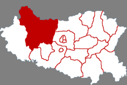
Wu'an 武安市 Wuan | |
---|---|
Coordinates: 36°41′49″N114°12′14″E / 36.697°N 114.204°E | |
Country | People's Republic of China |
Province | Hebei |
Prefecture-level city | Handan |
Area | |
• County-level city | 1,806.0 km2 (697.3 sq mi) |
Population (2020) | |
• County-level city | 811,631 |
• Urban | 453,442 |
Time zone | UTC+8 (China Standard) |
Wu'an | |||||||||
---|---|---|---|---|---|---|---|---|---|
Chinese | 武安 | ||||||||
Literal meaning | War-&-Peace | ||||||||
|
Wu'an is a county-level city in the southwest of Hebei Province,China,bordering Shanxi Province to the west. It is under the administration of the prefecture-level city of Handan.
In August 1949,Wu'an was one of three counties to be detached from Handan and attached to Pingyuan Province. In 1952,as Pingyuan dissolved,Wu'an returned to Handan.
As of 2020,Wu'an had a population of approximately 812,000. [1] [2]
Wu'an Town (武安镇),Kang'ercheng (康二城镇),Niuji (午汲镇),Cishan (磁山镇),Baiyan (伯延镇),Shucun (淑村镇),Datong,Wu'an (大同镇),Yicheng (邑城镇),Kuangshan (矿山镇),Hejin (贺进镇),Yangyi (阳邑镇),Paihui (徘徊镇),Yetao (冶陶镇)
Shangtuancheng Township (上团城乡),Bei'anzhuang Township (北安庄乡),Bei'anle Township (北安乐乡),Xitushan Township (西土山乡),Xisizhuang Township (西寺庄乡),Huoshui Township (活水乡),Shidong Township (石洞乡),Guantao Township (管陶乡),Majiazhuang Township (马家庄乡)
Climate data for Wu'an (1999–2020 normals,extremes 1981–2010) | |||||||||||||
---|---|---|---|---|---|---|---|---|---|---|---|---|---|
Month | Jan | Feb | Mar | Apr | May | Jun | Jul | Aug | Sep | Oct | Nov | Dec | Year |
Record high °C (°F) | 20.0 (68.0) | 22.4 (72.3) | 32.9 (91.2) | 41.0 (105.8) | 39.7 (103.5) | 43.8 (110.8) | 40.6 (105.1) | 38.4 (101.1) | 40.7 (105.3) | 31.7 (89.1) | 28.9 (84.0) | 18.8 (65.8) | 43.8 (110.8) |
Mean daily maximum °C (°F) | 4.1 (39.4) | 8.1 (46.6) | 15.7 (60.3) | 22.4 (72.3) | 28.1 (82.6) | 31.9 (89.4) | 31.6 (88.9) | 29.9 (85.8) | 26.3 (79.3) | 20.9 (69.6) | 13.0 (55.4) | 6.2 (43.2) | 19.9 (67.7) |
Daily mean °C (°F) | −1.0 (30.2) | 2.6 (36.7) | 9.7 (49.5) | 16.3 (61.3) | 22.3 (72.1) | 26.3 (79.3) | 27.0 (80.6) | 25.4 (77.7) | 21.1 (70.0) | 15.2 (59.4) | 7.5 (45.5) | 1.1 (34.0) | 14.5 (58.0) |
Mean daily minimum °C (°F) | −4.8 (23.4) | −1.7 (28.9) | 4.6 (40.3) | 10.7 (51.3) | 16.8 (62.2) | 21 (70) | 22.9 (73.2) | 21.5 (70.7) | 16.8 (62.2) | 10.7 (51.3) | 3.3 (37.9) | −2.7 (27.1) | 9.9 (49.9) |
Record low °C (°F) | −15.0 (5.0) | −12.3 (9.9) | −6.0 (21.2) | −0.8 (30.6) | 7.6 (45.7) | 12.9 (55.2) | 17.0 (62.6) | 12.6 (54.7) | 9.2 (48.6) | −1.0 (30.2) | −8.3 (17.1) | −12.9 (8.8) | −15.0 (5.0) |
Average precipitation mm (inches) | 3.6 (0.14) | 8.3 (0.33) | 9.4 (0.37) | 27.9 (1.10) | 48.2 (1.90) | 53.4 (2.10) | 167.9 (6.61) | 123.6 (4.87) | 57.6 (2.27) | 26.8 (1.06) | 15.3 (0.60) | 3.5 (0.14) | 545.5 (21.49) |
Average precipitation days (≥0.1 mm) | 2.3 | 3.2 | 3.0 | 5.5 | 7.2 | 9.3 | 12.4 | 10.9 | 8.0 | 6.1 | 4.3 | 2.3 | 74.5 |
Average snowy days | 3.9 | 3.7 | 1.1 | 0.3 | 0 | 0 | 0 | 0 | 0 | 0 | 1.6 | 2.9 | 13.5 |
Average relative humidity (%) | 55 | 52 | 48 | 51 | 53 | 55 | 72 | 77 | 70 | 62 | 60 | 56 | 59 |
Mean monthly sunshine hours | 128.3 | 135.9 | 179.4 | 207.4 | 228.7 | 197.7 | 156.4 | 163.3 | 160.4 | 162.5 | 141.8 | 138.5 | 2,000.3 |
Percent possible sunshine | 42 | 44 | 48 | 52 | 52 | 45 | 35 | 39 | 44 | 47 | 47 | 46 | 45 |
Source:China Meteorological Administration [3] [4] |
Shahe is a county-level city in the prefecture-level city of Xingtai,in the southern part of Hebei province,China.
Linxi County is a county in the south of Hebei Province,China,bordering Shandong to the south and east. It is the southernmost county-level division of the prefecture-level city of Xingtai,and is located in its southeast corner. It has a population of 320,000 residing in an area of 542 km2 (209 sq mi).
Renze District formerly,Renxian,is a district in the southwest of Hebei province,China. It is under the administration of the prefecture-level city of Xingtai. It has a land area of 431 km2 (166 sq mi) and a population of 300,000. Its postal code is 055150. The county seat is located in Rencheng Town.
Xinji is a county-level city of Hebei Province,North China,it is under the administration of the prefecture-level city of Shijiazhuang. It is the easternmost county-level division of Shijiangzhuang. There are eight towns and seven townships under the administration of Xinji.
Zunhua is a county-level city in the northeast of Hebei province,China,bordering Tianjin to the west. It is under the administration of the prefecture-level city of Tangshan. Historic sites include the Eastern Qing Tombs.
Huanghua is a county-level city located in the Bohai Gulf coastal region of Hebei province,China. It is under the jurisdiction of the prefecture-level city of Cangzhou.
Wuyi is a county of southeastern Hebei province,China,served by China National Highway 106. It is under the administration of the prefecture-level city of Hengshui,and,as of 2004,had a population of 310,000 residing in an area of 830 km2 (320 sq mi).
Yu County,also known by its Chinese name Yuxian,is a county under the jurisdiction of the prefecture-level city of Zhangjiakou in northwestern Hebei province,China. Yuzhou town (蔚州镇) is the county seat.
Xian County or Xianxian is a county in the east of Hebei province of China. It is under the administration of the prefecture-level city of Cangzhou.
Pingyuan County is a county in the northwest of Shandong province,People's Republic of China. It is administered by the prefecture-level city of Dezhou. It has an area of 1,050 square kilometres (410 sq mi).
Jingxing County is a county of Hebei Province,North China,it is under the administration of the prefecture-level city of Shijiazhuang,the capital of the province.
Yangyuan County is a county in Zhangjiakou Prefecture,Hebei Province,China.
Huai'an County is a county in the northwest of Hebei,China. It is under the administration of Zhangjiakou City.
Lincheng County is a county in the southwest of Hebei province,People's Republic of China,in the foothills of the Taihang Mountains. It is under the administration of the prefecture-level city of Xingtai. In 2010,its population was 204,000 and lived in an area of 797 km2 (308 sq mi). It borders Neiqiu in the south,Longyao and Baixiang in the east,Gaoyi and Zanhuang in the north,and the province of Shanxi in the west.
Linzhang County is a county of southmost Hebei province,China,named after the Zhang River within its borders. It is under the administration of Handan City,and,as of 2004,it had a population of 590,000 residing in an area of 744 km2 (287 sq mi).
Ci County or Cixian is a county of Hebei,China. It is under the administration of Handan City.
Yongnian is an urban district of the city of Handan,Hebei province,China. It is the seat of the Roman Catholic Diocese of Yongnian.
Qiu County or Qiuxian is a county in the south of Hebei province,China. It is under the administration of Handan City.
Guantao County is a county of southern Hebei province,China,bordering Shandong's Guan County and Linqing to the east across the Wei Canal (卫运河). It is under the administration of Handan City,and has a population of 320,000 residing in an area of 456 km2 (176 sq mi). Jinan lies 160 kilometres (99 mi) to the east,Handan 75 km (47 mi) to the west,and Beijing 420 km (260 mi) to the north,and the county is served by G22 Qingdao–Lanzhou Expressway and China National Highways 106 and 309. The area was formerly part of Shandong Province.
Wei County or Weixian is a county in the south of Hebei province,China,bordering Henan province to the south. It is under the administration of the prefecture-level city of Handan.