Ōkataina Caldera

Last updated • 10 min readFrom Wikipedia, The Free Encyclopedia

Ōkataina Caldera
Ōkataina Volcanic Centre, Okataina Caldera, Okataina Volcanic Centre
Paeroa-Ngapouri-Rotomahana Faults.jpg
Okataina Volcanic Centre relationships to other nearby volcanic and tectonic structures
Highest point
Coordinates 38°10′S176°30′E / 38.167°S 176.500°E / -38.167; 176.500
Dimensions
Length28 km (17 mi) [1]
Width15 km (9.3 mi) [1]
Geography
New Zealand (relief map).png
Red triangle with thick white border.svg
Ōkataina Caldera
NZ-NI plain map.png
Red triangle with thick white border.svg
Ōkataina Caldera
Ōkataina Caldera (North Island)
Country New Zealand
Region Bay of Plenty
Geology
Rock age Pleistocene - Meghalayan (0.625–0.0001  Ma ) [2]
O
S
D
C
P
T
J
K
Pg
N
Mountain type Caldera
Volcanic region Taupō Volcanic Zone
Last eruption 1886 Tarawera, 1973 Hydrothermal in Waimangu Volcanic Rift Valley
Climbing
Access State Highway 5 (New Zealand)
The 1886 eruption of Mount Tarawera, as depicted in this contemporary painting by Charles Blomfield, is the most recent major eruption from the Okataina Caldera. Charles-Blomfield-Mount-Tarawera-in-eruption-June-10-1886.jpg
The 1886 eruption of Mount Tarawera, as depicted in this contemporary painting by Charles Blomfield, is the most recent major eruption from the Ōkataina Caldera.

Ōkataina Caldera (Ōkataina Volcanic Centre, also spelled Okataina) is a volcanic caldera and its associated volcanoes located in Taupō Volcanic Zone of New Zealand's North Island. It has several actual or postulated sub calderas. The Ōkataina Caldera is just east of the smaller separate Rotorua Caldera and southwest of the much smaller Rotomā Embayment which is usually regarded as an associated volcano. It shows high rates of explosive rhyolitic volcanism although its last eruption was basaltic. The postulated Haroharo Caldera contained within it has sometimes been described in almost interchangeable terms with the Ōkataina Caldera or volcanic complex or centre and by other authors as a separate complex defined by gravitational and magnetic features. [3] :14. [a] Since 2010 other terms such as the Haroharo vent alignment, Utu Caldera, Matahina Caldera, Rotoiti Caldera and a postulated Kawerau Caldera are often used, [2] rather than a Haroharo Caldera classification. [3] :2

Contents

Geography

The caldera covers an area of about 450 square kilometres (170 sq mi), stretching from Lake Rotoehu in the north to Lake Rotomahana in the south. [4] The north east boundary bisects Lake Rotoiti and the north east includes all of Lake Rotomā. The south west corner is defined by the domes of the Ōkareka Embayment and the Waimangu Volcanic Rift Valley while the south east aspect is dominated by Mount Tarawera and the volcanic badlands of the Puhipuhi Basin. The caldera also contains several lakes, including part or all of Lake Ōkareka, Lake Ōkataina, Lake Rotoehu, Lake Rotomā, Lake Rotoiti, Lake Rotomahana, Lake Tarawera and Lake Tikitapu. [4]

Geology

The overwhelming volcanic deposits are rhyolite, with some basalt and one area of dacite. The caldera is now thought to contain the Utu Caldera, the major event Matahina Caldera, the Rotoiti Caldera, and the Kawerau Caldera with three associated geologically collapse structure embayments. [2] These are Rotomā Embayment, historically regarded as a caldera, the Ōkareka Embayment as another, now in-filled caldera and the Puhipuhi Embayment. The oldest parts of the caldera basement are now over 5 km (3.1 mi) deep and the younger Rotoiti and Kawerau calderas are still 2.5 km (1.6 mi) deep and largely infilled by eruptives. [5] [2]

Eruptions

Okataina Caldera
Map centered to show selected surface volcanic deposits including all the present surface Ōkataina Caldera ignimbrites. The present surface ignimbrites are various light violet shades which are identical for any single source, but other eruptions breakup the ignimbrite sheets. This map shows less detail of recent eruptions of the Ōkataina Caldera than the other map on the page. Clicking on the map enlarges it, and enables panning and mouseover of volcano name/wikilink and ages before present. Key for the volcanics that are shown with panning is:    basalt (shades of brown/orange),    monogenetic basalts,
  undifferentiated basalts of the Tangihua Complex in Northland Allochthon,
  arc basalts,  arc ring basalts,
   dacite,
   andesite (shades of red),   basaltic andesite,
   rhyolite, (ignimbrite is lighter shades of violet),
and   plutonic. White shading is selected caldera features.

The caldera has seen six eruptions in the past 10,000 years, most recently the 1886 Mount Tarawera eruption in the caldera's southeastern corner. The caldera contains two major lava dome complexes, the Haroharo vent alignment in the north and Tarawera vent alignment in the south. These two vent alignments are associated with current subsidence in the last 20 years of about 1.5 cm/year (0.59 in/year) which is assumed to be because of mainly cooling and contraction of previous magma melt. [6] Other volcanoes connected with the caldera include Putauaki (Mount Edgecumbe) [7] and the maar crater of Lake Rotokawau which is most likely to have formed from a basaltic dike extrusion associated with the common magma mush body. [8]

Threat

While most currently active New Zealand volcanoes produce small eruptions relatively frequently, Ōkataina's volcanoes tend to erupt very violently after intervals of centuries. As such, they pose significant potential threats to the Bay of Plenty Region but are also the most significant volcanic risk in New Zealand. [7] During the last 20,000 years, pyroclastic and lava eruptions have occurred of several types; low-silicate basalt eruptions, high-silicate rhyolite eruptions, and the rarer intermediate andesite and dacite eruptions. The most common magma type at Ōkataina is rhyolite. [7] The warning time before eruptions is currently suspected to be potentially hours as volcanic unrest signals are very non specific, historic composition analysis is consistent with this speed from magma reservoir to surface and this was all the warning given by the only rhyolitic eruption of the modern era. [9]

Eruption mechanism

The underlying arc volcanism is driven initially by large inputs of basaltic melt from the subducted Pacific Plate. These basaltic melts often never reach the surface due to a relatively high density of the magma compared to the surrounding Australian Plate crust, but may trigger earthquake swarms. [10] Usually, these intrusions cool in the crust and then either solidify to a gabbroic igneous intrusion (also known as a pluton) at depth or are associated with the generation of more evolved magmas with higher silicate content that separate. They may then as evolved intrusions, cool further without erupting to form a felsic intrusion or can ascend to then erupt as rhyolite, dacite, or andesite. Sometimes such eruptions are believed to be primed by a basaltic melt predecessor. In the case of the Ōkataina Caldera the sub-surface architecture is known to be made up of discrete melt-mush pockets, and with one dacite exception already mentioned, these are rhyolitic. The melt-mush pockets are mainly between 5 and 8 km (3.1 and 5.0 mi) in depth but one has been characterised at 3 km (1.9 mi) depth. [5] The pockets have erupted compositionally distinct magmas in single eruptions. [2] The composition is related to heat and volatiles transferred between the parent basalts and such rhyolites over the time the sub pocket has been maturing. Basaltic-rhyolitic magma interaction definitely happens from local and world wide studies, and will also be a factor in the many different eruption styles that have occurred. [2] Sometimes basalt appears to lead the eruption, at other times it has been postulated that tectonic earthquakes are the final enabler of an eruption. [2] [11]

Any basaltic magmas that do reach the surface will have traversed this complicated crustal region and may erupt as a dyke. This is believed to have happened with the 1886 Mount Tarawera eruption. [2]

Okataina Caldera
Ōkataina deposits in the years after the Rotoiti eruption with darker shading of violet for more recent. Clicking on the map enlarges it, and enables panning and mouseover of name/wikilink and ages before present. Key for the volcanics is:
   basalt    dacite    rhyolite / ignimbrite  Definite vents.
  Ōkataina Volcanic Centre with its embayments
  postulated sub calderas of Cole et al. 2009 onwards

History

It is likely that the volcanic history of the area began some 625,000 years ago. [12] The caldera was formed by at least five huge eruptions between 400,000 and 50,000 years ago.

The oldest eruptive sub caldera is called the Utu caldera and is located in the south central portion. The basement of this sub caldera is about 5 km (3.1 mi) below present ground level. [2]

The most significant collapse event, with an eruptive volume of 150 cubic kilometres (36 cu mi) was 280,000 years ago. [13] This collapse was associated with eruption of the Matahina Ignimbrite which covers over 2,000 km2 (770 sq mi) of the central North Island. [1] The second major phase Matahina sub caldera is to the south east and its basement is also about 5 km (3.1 mi) below present ground level. [2] The original shape of the Matahina caldera has been modified (and buried/destroyed) by various events including at least eight smaller eruptions between 70,000 and 24,000 years ago. For example the dacite Puripuri basin/embayment is a subsidence related feature. This subsidence is related to the lateral movement of the underlying magma towards the eastern caldera margins. [2]

The paired eruptions approximately 50,000 years ago [14] of Rotoiti and at Earthquake Flat at far northern and southern ends of the caldera respectively had eruptive volumes of 120 cubic kilometres (29 cu mi) and 10 cubic kilometres (2.4 cu mi). [1] The resulting Rotoiti sub caldera is to the north of the Utu Caldera. [2]

Between this eruption and 21,000 years ago over 81 km3 (19 cu mi) of Mangaone silicic plinian tephras or pyroclastic flow deposits occurred but it is unknown where the eruptions were centered. One of these events can be assigned to the Kawerau ignimbrite eruption of 33,000 years ago, with its location within the central part of the Matahina Caldera at level of the Puhipuhi Basin. [1] An area of low gravity on gravimetric studies is consistent with the fourth phase Kawerau Caldera being here and its basement being about 2 km (1.2 mi) below present ground level. [2]

Although the latest caldera models include the Haroharo vent alignment they do not allow for the separate existence of a Haroharo caldera as many had historically postulated existed. [2]

More recently volcanoes within the caldera are known to have erupted eleven times in the last 21,000 years, with all but two of those eruptions being rhyolite. [15] [7] The Rotoma eruptions occurred in a north eastern embayment, and again like with the case of the Puripuri basin, the magma erupted from a lateral reservoir is associated with subsidence back to the eastern Rotoiti caldera margin. The Ōkareka Embayment to the west is also associated with caldera rim subsidence, this time the western shared rims of the Utu, Matahina and Rotoiti calderas. [2]

Two of these eruptions, both at Tarawera, occurred within the last 2000 years (in 1886 and c.1314AD). The most explosive of the eruptions in the last 21,000 years is likely to have been on the Haroharo vent alignment at about 5500 BCE. This ejected some 17 km3 (4.1 cu mi) of magma. [7] During the last 21,000 years the Ōkataina volcano has contributed a total magma eruptive volume of about 80 km3 (19 cu mi) in all its eruptions. [15] [16]

In summary the more significant eruptions have been: [13] [12] [1]

Significant Eruptions Ōkataina Caldera (bold if caldera forming, dates corrected for multiple source uncertainty) [17]
Year before presentCalendar dateEruptive nameVent / Vent alignment / CalderaVolume eruptedNotes
138 cal.yr10 June 1886 CE Tarawera Tarawera 1 km3 (0.24 cu mi) DRE Basaltic eruption [13] [12] [1] [17]
710 ± 12 cal.yr1314 ± 12 CEKaharoa tephra Tarawera 5 km3 (1.2 cu mi) DRE [13] [18] [17] This eruption was immediately preceded by a rupture on the Edgecumbe fault. [19]
3710 ± 10 cal.yr1760 ± 10 BCERotokawau Rotokawau -Basaltic eruption [20] :21 [21] [22]
5526 ± 145 cal.yr3576 ± 145 BCEWhakatane Haroharo 13 km3 (3.1 cu mi) DRE [13] [17]
7940 ± 257 cal.yr5990 ± 257 BCEMamaku Haroharo 17 km3 (4.1 cu mi) DRE [13] [23] [17]
9423 ± 120 cal.yr7473 ± 120 BCERotoma Haroharo 8 km3 (1.9 cu mi) DRE [13] [17]
14,009 ± 155 cal.yr12059 ± 155 BCEWaiohau tephra Tarawera 10 km3 (2.4 cu mi) DRE [13] [17]
15,635 ± 412 cal.yr13685 ±412 BCERotorua tephra Haroharo 4 km3 (0.96 cu mi) DRE [13] [17]
17,496 ± 462 cal.yr15546 ± 462 BCERerewhakaaitu tephra Tarawera 5 km3 (1.2 cu mi) DRE [13] [24] [17]
23,525–370+230 cal.yr21575 BCEOkareka Tarawera 8 km3 (1.9 cu mi) DRE [13] [17] [b]
25,171 ± 964 cal.yr23221 BCETe Rere Kawerau Caldera (Haroharo)13 km3 (3.1 cu mi) DRE [13] 33,000 years ago Kawerau (previously called Kaingaroa and miss-assigned to be 200,000 years older) [1] now corrected to 25,171 years ago [17]
31,500 cal.yr29550 BCEUnit LUnknown8.1 km3 (1.9 cu mi) Tephra [25] [26]
32,500 cal.yr30550 BCEOmataroaUnknown16.2 km3 (3.9 cu mi) Tephra [25] [26]
32,800 cal.yr30850 BCEAwakeriUnknown0.77 km3 (0.18 cu mi) Tephra [25] [26]
33,000 cal.yr31050 BCEMangaoneUnknown19.1 km3 (4.6 cu mi) Tephra [25] [26]
34,500 cal.yr32550 BCEUnit HUnknown0.1 km3 (0.024 cu mi) Tephra [25] [26]
35,000 cal.yr33050 BCEUnit GUnknown2.5 km3 (0.60 cu mi) Tephra [25] [26]
36,100 cal.yr34150 BCEHauparuUnknown15.2 km3 (3.6 cu mi) Tephra [25] [26]
36,700 cal.yr34750 BCETe MahoeUnknown0.9 km3 (0.22 cu mi) Tephra [25] [26]
36,800 cal.yr34850 BCEMaketuUnknown11 km3 (2.6 cu mi) Tephra [25] [26]
38,000 approx. cal.yr36050 BCEUnit C (Pupuwharau then Pongakawa)Unknown0.7 km3 (0.17 cu mi) Tephra [25] [26]
39,000 approx. cal.yr37050 BCENgamotuUnknown4.6 km3 (1.1 cu mi) Tephra [25] [26]
40,000 approx. cal.yr38050 BCEUnit AUnknown0.44 km3 (0.11 cu mi) Tephra [25]
49,000 approx. cal.yr47050 BCEEarthquake FlatEarthquake Flat [c] [25]
about 50,000 cal.yr48050 BCE Rotoiti/Rotoehu tephra Rotoiti Caldera (Haroharo)'130 km3 (31 cu mi) DRE Basalt was emplaced on the floor of the rhyolitic reservoir. [25] [d] [27] :188–90 [26] [28]
50,000 + cal.yr48050 BCEMatahi ScoriaSuspected to be Rotoiti CalderaBasaltic immediately pre-Rotoiti [16] [25]
about 51,00049050 BCEPuhipuhi Dacite Puhipuhi Embayment 48,000+ [1] ie is definitely before Rotoiti but age depends on actual Rotoiti age.
96,000 approx. cal.yr94050 BCEMoerangiMoerangi Dome [25]
188,000 approx. cal.yr186050 BCETutaeheke/Hap-KapengaTutaeheke Dome [25]
240,000 + cal.yr238050 BCEPokopoko pyroclasticsUnknown [25]
240,000 + cal.yr238050 BCEOnuku pyroclasticsUnknown [25]
280,000 cal.yr278000 BCEMatahina Matahina Caldera 150 km3 (36 cu mi) DRE Recharging basalt found on top ignimbrite layer. [25] [13] The latest age (not literature peer reviewed) is claimed at 322,000 ± 7,000 [29] which appears to be a reversion to the initial uncorrected timing. Also previously timed 230,000. [1] - large as caldera collapse
280,000 + cal.yr280000 BCEMatawhauraMatawhaura Dome [25]
280,000 + cal.yr280000 BCEMurupara pyroclasticsUnknown [25]
280,000 + cal.yr280000 BCEWairuaWairua Dome [25]
280,000 + cal.yr280000 BCEMaunawhakamanaMaunawhakamana Dome [25]
280,000 + cal.yr280000 BCEWhakapoungakau Whakapoungakau Dome Lost volume with Matahini eruption [25]
557,000 cal.yr555000 BCEUtu Utu Caldera [16]
625,000 cal.yr623000 BCEŌkatainaŌkataina [12]

Tectonics

Faults are not defined under this very active caldera. The active Paeroa Fault terminates at the caldera edge and the active Ngapouri-Rotomahana Fault is just to the south. The two recently active main vent alignments in the Ōkataina Caldera, the Horahora and Tarawera vents, are parallel with these identifiable faults outside the caldera, although the faults are not on the exact vent line. [1] In the last 9,500 years, four of the seven major ruptures of the Manawahe Fault have been associated in time with a volcanic eruption of the Okataina volcanic centre. This fault is just to the east of Lake Rotoma at the boundary between the tectonic Whakatāne Graben and the magmatic Ōkataina segments of the Taupō Rift. These are the Whakatane eruption of about 5500 years ago, the Mamaku eruption of about 8000 years ago and at least two fault ruptures in before or during the Rotoma eruption of 9500 years ago. [13] Similarly the Ngapouri-Rotomahana Fault and Paeroa Fault have multiple ruptures associated in time with volcanism including immediately prior to the Mamaku and Rotoma rhyolite eruptions in the case of the Paeroa Fault and of the Ngapouri-Rotomahana Fault immediately prior to the Kaharoa eruption. [11] At least 30% of major Taupō Volcanic Zone eruptions have now been associated with significant local fault ruptures within 30 km (19 mi) of the eruption. [13]

Notes

  1. Possibly started from
    HaroHaro pile ... are rhyolite lavas of the Okataina Volcanic Centre, extruded on the floor of Haroharo Caldera
    J. Healy, Geology of the Rotoroa District 1962, p54-55
    with the author presuming that certain ignimbrites came from this source. The term Haroharo Caldera was increasingly used in academic papers in the 1970's and 1980's but changed as the detailed geology became better understood. The difficulty was that by then the term Haroharo Caldera was established. The term is still used, and currently is defined by gravity and magnetic differences.
  2. Sources based on Darragh et al. 2006 give timings about 2000 years earlier for the Okareka eruption. [23]
  3. This eruption is assigned by some to the Kapenga Caldera. See discussion in that article
  4. Ages assigned to the Rotoiti/Rotoehu eruptives currently appear to vary depending upon methodology by about 15,000 years in the literature. This is problematic as many ages of volcanics in the Northern North Island would be more definite if a single agreed value existed. The issue of previous inaccurate age assignment started with a new figure for Rotoehu Ash of 64,000 ± 1650 cal.yr.(Wilson et al 1992) which was initially widely accepted. The youngest age assigned is 44,300 years ago (Shane et al 2003). The problems with some older techniques were possibly not resolved with new techniques that could explain the discrepancy and that resulted in 47,400 ± 1500 years ago (Flude et al 2016), while one recent peer reviewed work gave 61,000 ± 1400 cal.yr (Villamor et al 2022). Other, mainly recent chronology studies have a younger date of 45,200 ± 1650 cal.yr. (Danišík et al 2020 and 2012), 45,100 ± 3300 years ago (Peti et al 2020), 47,400 ± 1500 years ago (Gilgour et al 2008), and before these 65,000 years ago (Spinks 2005). A recent review of 27 determinations gave the consensus range as between about 45 and about 55 cal ka (Hopkins et al. 2021). For more on this age issue see notes to Puhipuhi Embayment.

Related Research Articles

<span class="mw-page-title-main">Taupō Volcanic Zone</span> Active volcanic zone in New Zealand

The Taupō Volcanic Zone (TVZ) is a volcanic area in the North Island of New Zealand. It has been active for at least the past two million years and is still highly active.

<span class="mw-page-title-main">Mount Tarawera</span> Volcano in New Zealand

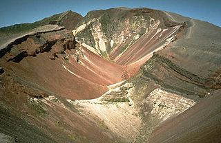
Mount Tarawera is a volcano on the North Island of New Zealand within the older but volcanically productive Ōkataina Caldera. Located 24 kilometres southeast of Rotorua, it consists of a series of rhyolitic lava domes that were fissured down the middle by an explosive basaltic eruption in 1886. While the 1886 eruption was basaltic, study has shown there was only a small basalt component to the previous recent rhyolitic predominant eruptions. This eruption was one of New Zealand's largest historical eruptions, and killed an estimated 120 people. The fissures run for about 17 kilometres (11 mi) northeast–southwest.

<span class="mw-page-title-main">Plinian eruption</span> Type of volcanic eruption

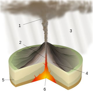
Plinian eruptions or Vesuvian eruptions are volcanic eruptions marked by their similarity to the eruption of Mount Vesuvius in 79 AD, which destroyed the ancient Roman cities of Herculaneum and Pompeii. The eruption was described in a letter written by Pliny the Younger, after the death of his uncle Pliny the Elder.

<span class="mw-page-title-main">Lake Rotorua</span> Lake in the North Island of New Zealand

Lake Rotorua is the second largest lake in the North Island of New Zealand by surface area, and covers 79.8 km2. With a mean depth of only 10 metres it is considerably smaller than nearby Lake Tarawera in terms of volume of water. It is located within the Rotorua Caldera in the Bay of Plenty Region.

<span class="mw-page-title-main">Lake Rotoiti (Bay of Plenty)</span> Lake in the North Island of New Zealand

Lake Rotoiti is a lake in the Bay of Plenty region of New Zealand. It is the northwesternmost in a chain of lakes formed within the Okataina Caldera. The lake is close to the northern shore of its more famous neighbour, Lake Rotorua, and is connected to it via the Ohau Channel. It drains to the Kaituna River, which flows into the Bay of Plenty near Maketu.

The region around the city of Rotorua, in New Zealand's North Island, contains several lakes which have a total area of about 250 square kilometres. The term Rotorua lakes is ambiguous as it has been used historically for a New Zealand administrative area. From biggest to smallest, these are Lake Rotorua, Lake Tarawera, Lake Rotoiti, Lake Rotomā, Lake Okataina, Lake Rotoehu, Lake Rotomahana, Lake Rerewhakaaitu, Lake Rotokākahi, Lake Okareka and Lake Tikitapu. There are also smaller lakes including: Lake Okaro, Lake Rotokawa, Lake Rotokawau and Lake Rotongata. Most of the lakes have formed due to volcanic activity and some have current geothermal activity. The region is part of the Taupō Volcanic Zone, the world's most active area of explosive silicic volcanic activity in geologically recent time.

<span class="mw-page-title-main">1886 eruption of Mount Tarawera</span> Volcanic eruption in New Zealand

The 1886 eruption of Mount Tarawera was a violent volcanic eruption that occurred in the early hours of 10 June 1886 at Mount Tarawera, near Rotorua on New Zealand's North Island. The eruption reached an estimated volcanic explosivity index (VEI) of 5 and killed an estimated 120 people, making it the largest and deadliest in New Zealand during the past 500 years, a period that includes the entirety of European history in New Zealand.

<span class="mw-page-title-main">Lake Rotokawau (Bay of Plenty)</span> Lake in the North Island of New Zealand

Lake Rotokawau is a small volcanic lake 4.1 km (2.5 mi) east of Lake Rotorua in the Bay of Plenty region of New Zealand's North Island. The name is also used for lakes in the Kaipara District, Chatham Islands, on Aupouri Peninsula and near Lake Waikare in Waikato. Access is via Lake Rotokawau Road, from SH30 at Tikitere. The lake is owned and managed by Ngāti Rangiteaorere.

The Haroharo Caldera is a 26 by 16 km postulated volcanic feature in Taupō Volcanic Zone of the North Island, New Zealand within the larger and older Ōkataina Caldera. Since 2010 further studies have tended to use the terms Haroharo vent alignment, Utu Caldera, Matahina Caldera, Rotoiti Caldera and a postulated Kawerau Caldera to the features assigned to it. However the name is used in the peer reviewed literature to summarise and group these features based on gravitational and magnetic features.

<span class="mw-page-title-main">Kapenga Caldera</span> Volcanic caldera in New Zealand

The Kapenga Caldera in New Zealand’s Taupō Volcanic Zone lies in a lowland area immediately south of Lake Rotorua through the Hemo Gap in the Rotorua Caldera rim. Features of the caldera have developed over a period of about 900,000 years. At some time more than 60,000 years ago, Lake Rotorua drained through the Hemo Gap, and part of the Kapenga Caldera floor was likely occupied by a lake, which has been referred to as Kapenga.

<span class="mw-page-title-main">Rotomā Caldera</span> Volcanic caldera in the North Island of New Zealand

The relatively small Rotomā Caldera is in the Taupō Volcanic Zone in the North Island of New Zealand.

<span class="mw-page-title-main">Paeroa Fault</span> Active fault in New Zealand

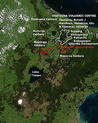
The Paeroa Fault is a seismically active area in the Taupō District, Waikato Region of the central North Island of New Zealand.

<span class="mw-page-title-main">Ōkāreka Embayment</span> Volcano in North Island, New Zealand

The Ōkāreka Embayment is a volcanic feature in Taupo Volcanic Zone of New Zealand. Its most significant recent volcanic eruption was about 15,700 years ago and this deposited the widespread Rotorua tephra that reached beyond Auckland.

<span class="mw-page-title-main">Horohoro Fault</span>

The Horohoro Fault is in the old Taupō Rift of the central North Island of New Zealand and is associated with the spectacular Horohoro Cliffs.

The Taupō Fault Belt contains many almost parallel active faults, and is located in the Taupō Rift of the central North Island of New Zealand geographically between Lake Taupō and the lakes of Rotorua, Tarawera, Rotomahana and Rerewhakaaitu. The potential active fault density is very high, with only 0.1 to 1 km separating the north-east to south-west orientated normal fault strands on detailed mapping of part of the belt. The Waikato River bisects the western region of the belt.

<span class="mw-page-title-main">Tikitere Graben</span> A geological feature in the North Island of New Zealand

The Tikitere Graben is a intra-rift graben in the North Island of New Zealand that contains the Ohau Channel, which drains Lake Rotorua into Lake Rotoiti with a minimal drop between the lakes.

Much of the volcanic activity in the northern portions of the North Island of New Zealand is recent in geological terms and has taken place over the last 30 million years. This is primarily due to the North Island's position on the boundary between the Indo-Australian and Pacific plates, a part of the Pacific Ring of Fire, and particularly the subduction of the Pacific plate under the Indo-Australian plate. The activity has included some of the world's largest eruptions in geologically recent times and has resulted in much of the surface formations of the North Island being volcanic as shown in the map.

The Manawahe Fault line is a seismically active area in the Bay of Plenty Region of the central North Island of New Zealand with the potential to be involved with other faults in an Mw7.0 event.

<span class="mw-page-title-main">Puhipuhi Embayment</span> Volcanic area in North Island, New Zealand

The Puhipuhi Embayment is a volcanic feature in Taupo Volcanic Zone of New Zealand associated with the collapse of the Ōkataina Caldera wall to its west. Its latest significant volcanic eruption was about 31,500 years ago and this dating required a reassessment of recent activity at the Eastern extension of the Tarawera vent alignment.

The Rotoiti Caldera is a postulated, mainly infilled sub caldera of the Ōkataina Caldera based upon gravitational and magnetic evidence. While bathymetry of Lake Rotoiti is consistent with volcanic vents being present, they could be in an area of collapse subsidence outside the north western margins of the Rotoiti Caldera itself.

References

  1. 1 2 3 4 5 6 7 8 9 10 11 Spinks, Karl D. (2005). Rift Architecture and Caldera Volcanism in the Taupo Volcanic Zone, New Zealand (Thesis).
  2. 1 2 3 4 5 6 7 8 9 10 11 12 13 14 15 Hughes, Ery C.; Law, Sally; Kilgour, Geoff; Blundy, Jon D.; Mader, Heidy M. (2023). "Storage, evolution, and mixing in basaltic eruptions from around the Okataina Volcanic Centre, Taupō Volcanic Zone, Aotearoa New Zealand". Journal of Volcanology and Geothermal Research. 434 (107715): 107715. doi:10.1016/j.jvolgeores.2022.107715. hdl: 20.500.11820/9f5c151c-1f2e-47ed-a264-7649eacdf669 . ISSN   0377-0273. S2CID   253783414.
  3. 1 2 Caratori Tontini, F; de Ronde, CEJ; Black, J; Stucker, VK; Walker, SL (2023). "The geology and geophysics of Lake Tarawera, New Zealand: Implications for sublacustrine geothermal activity". Journal of Volcanology and Geothermal Research. 433. doi: 10.1016/j.jvolgeores.2022.107731 . ISSN   0377-0273.
  4. 1 2 McKinnon, M., "Okataina caldera and its neighbours," Te Ara - Encyclopedia of New Zealand , 1 May 2015. Retrieved 11 June 2022.
  5. 1 2 Bannister, Stephen; Bertrand, Edward A.; Heimann, Sebastian; Bourguignon, Sandra; Asher, Cameron; Shanks, Jackson; Harvison, Adrian (2022). "Imaging sub-caldera structure with local seismicity, Okataina Volcanic Centre, Taupo Volcanic Zone, using double-difference seismic tomography". Journal of Volcanology and Geothermal Research. 431 (107653). doi:10.1016/j.jvolgeores.2022.107653. ISSN   0377-0273. S2CID   251914262.
  6. Hamling, Ian J.; Kilgour, Geoff; Hreinsdóttir, Sigrun; Bertrand, Edward; Bannister, Stephen (2022). "Estimating the distribution of melt beneath the Okataina Caldera, New Zealand: An integrated approach using geodesy, seismology and magnetotellurics". Journal of Volcanology and Geothermal Research. 426 (107549). doi: 10.1016/j.jvolgeores.2022.107549 . ISSN   0377-0273.
  7. 1 2 3 4 5 "Okataina Volcanic Centre Geology," GNS science. Retrieved 11 June 2022.
  8. Bertrand, E.A.; Kannberg, P.; Caldwell, T.G.; Heise, W.; Constable, S.; Scott, B.; Bannister, S.; Kilgour, G.; Bennie, S.L.; Hart, R.; Palmer, N. (2022). "Inferring the magmatic roots of volcano-geothermal systems in the Rotorua Caldera and Okataina Volcanic Centre from magnetotelluric models". Journal of Volcanology and Geothermal Research. 431 (107645): 107645. doi:10.1016/j.jvolgeores.2022.107645. ISSN   0377-0273. S2CID   251526385.
  9. Rooyakkers, S.M.; Faure, K.; Chambefort, I.; Barker, S.J.; Elms, H.C.; Wilson, C.J.; Charlier, B.L. (2023). "Tracking Magma-Crust-Fluid Interactions at High Temporal Resolution: Oxygen Isotopes in Young Silicic Magmas of the Taupō Volcanic Zone". Geochemistry, Geophysics, Geosystems. 24 (1). doi: 10.1029/2022GC010694 . S2CID   254807245.
  10. Benson, Thomas W.; Illsley-Kemp, Finnigan; Elms, Hannah C.; Hamling, Ian J.; Savage, Martha K.; Wilson, Colin J. N.; Mestel, Eleanor R. H.; Barker, Simon J. (2021). "Earthquake Analysis Suggests Dyke Intrusion in 2019 Near Tarawera Volcano, New Zealand". Frontiers in Earth Science. 8. doi: 10.3389/feart.2020.606992 . ISSN   2296-6463.
  11. 1 2 Berryman, Kelvin; Villamor, Pilar; Nairn, Ian; Begg, John; Alloway, Brent V.; Rowland, Julie; Lee, Julie; Capote, Ramon (2022). "Volcano-tectonic interactions at the southern margin of the Okataina Volcanic Centre, Taupō Volcanic Zone, New Zealand". Journal of Volcanology and Geothermal Research. 427 (107552): 107552. doi: 10.1016/j.jvolgeores.2022.107552 . hdl: 2292/59681 . ISSN   0377-0273. S2CID   248111450.
  12. 1 2 3 4 Cole, J.W., Deer ing, C.D., et al (2014) "Okataina Volcanic Centre, Taupo Volcanic Zone, New Zealand: A review of volcanism and synchronous pluton development in an active, dominantly silicic caldera system", Earth-science reviews, 128, 1–17. Abstract retrieved 11 June 2022.
  13. 1 2 3 4 5 6 7 8 9 10 11 12 13 14 15 Villamor, Pilar; Litchfield, Nicola J.; Gómez-Ortiz, David; Martin-González, Fidel; Alloway, Brent V.; Berryman, Kelvin R.; Clark, Kate J.; Ries, William F.; Howell, Andrew; Ansell, India A. (2022). "Fault ruptures triggered by large rhyolitic eruptions at the boundary between tectonic and magmatic rift segments: The Manawahe Fault, Taupō Rift, New Zealand". Journal of Volcanology and Geothermal Research. 427: 107478. doi:10.1016/j.jvolgeores.2022.107478. hdl: 2292/59828 . ISSN   0377-0273. S2CID   246258923.
  14. Gilgour, G.N.; Smith, R.T. (2008). "Stratigraphy, dynamics, and eruption impacts of the dual magma Rotorua eruptive episode, Okataina Volcanic Centre, New Zealand" (PDF). New Zealand Journal of Geology & Geophysics. 51 (4): 367–378. doi:10.1080/00288300809509871. S2CID   128976717.
  15. 1 2 Smith, Victoria; Shane, Phil; Nairn, I.A.; Williams, Catherine (2006-07-01). "Geochemistry and magmatic properties of eruption episodes from Haroharo linear vent zone, Okataina Volcanic Centre, New Zealand during the last 10 kyr". Bulletin of Volcanology. 69 (1): 57–88. doi:10.1007/s00445-006-0056-7. S2CID   129365367.
  16. 1 2 3 Cole, J. W.; Spinks, K. D. (2009). "Caldera volcanism and rift structure in the Taupo Volcanic Zone, New Zealand". Special Publications. 327 (1). London: Geological Society: 9–29. Bibcode:2009GSLSP.327....9C. doi:10.1144/SP327.2. S2CID   131562598.
  17. 1 2 3 4 5 6 7 8 9 10 11 Lowe, David; Ilanko, Tehnuka. "Pre-conference tephra data workshop – Hands-on session II: tephra excursion, Okareka Loop Road (29 January 2023)" . Retrieved 2023-03-21.
  18. Froggatt, P. C.; Lowe, D. J. (1990). "A review of late Quaternary silicic and some other tephra formations from New Zealand: Their stratigraphy, nomenclature, distribution, volume, and age". New Zealand Journal of Geology and Geophysics. 33 (1): 89–109. doi: 10.1080/00288306.1990.10427576 . hdl: 10289/176 .
  19. Beanland, Sarah; Berryman, Kelvin R.; Blick, Graeme H. (1989). "Geological investigations of the 1987 Edgecumbe earthquake, New Zealand". New Zealand Journal of Geology and Geophysics. 32 (1): 73–91. doi:10.1080/00288306.1989.10421390.:83
  20. Elms, Hannah Corinne (2022). Geochemistry, Magmatic Processes and Timescales of Recent Rhyolitic Eruptives of the Ōkataina Volcanic Centre, Taupō Volcanic Zone, Aotearoa/New Zealand: PhD thesis (Thesis). Te Herenga Waka—Victoria University of Wellington. pp. 1–316.
  21. Beanland, S.; Houghton, B. (1991). "Rotokawau tephra: basaltic maars in Okataina volcanic centre, Taupo Volcanic Zone". Records N.Z. Geological Survey (43): 37–43.
  22. Leonard, G.S.; Begg, J.G.; Wilson, C.J.N. (2010). Geology of Rotorua area. 1:25000 Geological map 5. GNS Science, Lower Hutt, New Zealand. pp. 1–102. ISBN   978-0-478-19778-5 . Retrieved 16 March 2024.:49,100
  23. 1 2 Darragh, Miles; Cole, Jim; Nairn, Ian; Shane, Phil (2006). "Pyroclastic stratigraphy and eruption dynamics of the 21.9 ka Okareka and 17.6 ka Rerewhakaaitu eruption episodes from Tarawera Volcano, Okataina Volcanic Centre, New Zealand". New Zealand Journal of Geology and Geophysics. 49 (3): 309–328. doi:10.1080/00288306.2006.9515170. S2CID   59137127.
  24. Shane, Phil; Martin, S.B.; Smith, Victoria C.; Beggs, K.R. (2007). "Multiple rhyolite magmas and basalt injection in the 17.7 ka Rerewhakaaitu eruption episode from Tarawera volcanic complex, New Zealand". Journal of Volcanology and Geothermal Research. 164 (1–2): 1–26. doi:10.1016/j.jvolgeores.2007.04.003.
  25. 1 2 3 4 5 6 7 8 9 10 11 12 13 14 15 16 17 18 19 20 21 22 23 24 25 Bouvet de Maisonneuve, C.; Forni, F.; Bachmann, O. (2021). "Magma reservoir evolution during the build up to and recovery from caldera-forming eruptions – A generalizable model?". Earth-Science Reviews. 218: 103684. doi:10.1016/j.earscirev.2021.103684. hdl: 10356/161241 . ISSN   0012-8252. S2CID   236237501.
  26. 1 2 3 4 5 6 7 8 9 10 11 12 Danišík, Martin; Lowe, David J.; Schmitt, Axel K.; Friedrichs, Bjarne; Hogg, Alan G.; Evans, Noreen J. (2020). "Sub-millennial eruptive recurrence in the silicic Mangaone Subgroup tephra sequence, New Zealand, from Bayesian modelling of zircon double-dating and radiocarbon ages" (PDF). Quaternary Science Reviews. 246: 106517. doi:10.1016/j.quascirev.2020.106517. hdl:10289/13801. ISSN   0277-3791. S2CID   224864954.
  27. Hopkins, JL; Lowe, DJ; Horrocks, JL (3 July 2021). "Tephrochronology in Aotearoa New Zealand". New Zealand Journal of Geology and Geophysics. 64 (2–3): 153–200. doi: 10.1080/00288306.2021.1908368 . hdl: 10289/14349 .
  28. Peti, Leonie; Fitzsimmons, Kathryn E.; Hopkins, Jenni L.; Nilsson, Andreas; Fujioka, Toshiyuki; Fink, David; Mifsud, Charles; Christl, Marcus; Muscheler, Raimund; Augustinus, Paul C. (2020). "Development of a multi-method chronology spanning the Last Glacial Interval from Orakei maar lake, Auckland, New Zealand". Geochronology. 2 (2): 367–410. doi: 10.5194/gchron-2-367-2020 . hdl: 20.500.11850/553903 .
  29. Kidd, Maia Josephine (2021). Landscape Evolution in Ignimbrite Terrain: a study of the Mamaku Plateau, Taupō Volcanic Zone, New Zealand - Masters thesis, University of Canterbury (PDF) (Thesis).