
Kakadu National Park is a protected area in the Northern Territory of Australia, 171 km (106 mi) southeast of Darwin. It is a World Heritage Site. Kakadu is also gazetted as a locality, covering the same area as the national park, with 313 people recorded living there in the 2016 Australian census.

The Black Rock Desert is a semi-arid region of lava beds and playa, or alkali flats, situated in the Black Rock Desert–High Rock Canyon Emigrant Trails National Conservation Area, a silt playa 100 miles (160 km) north of Reno, Nevada, that encompasses more than 300,000 acres (120,000 ha) of land and contains more than 120 miles (200 km) of historic trails. It is in the northern Nevada section of the Great Basin with a lakebed that is a dry remnant of Pleistocene Lake Lahontan.

The Burdekin River is a river in North and Far North Queensland, Australia. The river rises on the northern slopes of Boulder Mountain at Valley of Lagoons, part of the western slope of the Seaview Range, and flows into the Coral Sea at Upstart Bay over 200 kilometres (124 mi) to the southeast of the source, with a catchment area of approximately 130,000 square kilometres (50,000 sq mi). The Burdekin River is Australia's largest river by (peak) discharge volume.

The Maribyrnong River is a perennial river of the Port Phillip catchment, located in the north–western suburbs of Melbourne, in the Australian state of Victoria.

The Namoi River, a major perennial river that is part of the Barwon catchment of the Murray–Darling basin, is located in the Northern Tablelands and North West Slopes districts of New South Wales, Australia.

Greater Western Sydney (GWS) is a large region of the metropolitan area of Greater Sydney, New South Wales (NSW), Australia that generally embraces the north-west, south-west, central-west, far western and the Blue Mountains sub-regions within Sydney's metropolitan area and encompasses 11 local government areas: Blacktown, Blue Mountains, Camden, Campbelltown, Cumberland, Fairfield, Hawkesbury, Liverpool, Parramatta, Penrith and Wollondilly. It includes Western Sydney, which has a number of different definitions, although the one consistently used is the region composed of ten local government authorities, most of which are members of the Western Sydney Regional Organisation of Councils (WSROC). The NSW Government's Office of Western Sydney calls the region "Greater Western Sydney".

The River Torrens is the most significant river of the Adelaide Plains. It was one of the main reasons for the siting of the city of Adelaide, capital of South Australia. It flows 85 kilometres (53 mi) from its source in the Adelaide Hills near Mount Pleasant, across the Adelaide Plains, past the city centre and empties into Gulf St Vincent between Henley Beach South and West Beach. The upper stretches of the river and the reservoirs in its watershed supply a significant part of the city's water supply.

Arkaroola is the common name for the Arkaroola Wilderness Sanctuary, a wildlife sanctuary situated on 610 square kilometres of freehold and pastoral lease land in South Australia. It is located 700 kilometres north of the Adelaide city centre in the Northern Flinders Ranges, adjacent to the Vulkathunha-Gammon Ranges National Park and the Mawson Plateau. The most common way to get there is by car, but air travel can be chartered from Parafield Airport, Adelaide Airport or Aldinga Airfield. It was used as a location set for the 2002 film The Tracker.
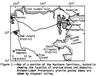
Alligator Rivers is the name of an area in an Arnhem Land region of the Northern Territory of Australia, containing three rivers, the East, West, and South Alligator Rivers. It is regarded as one of the richest biological regions in Australia, with part of the region in the Kakadu National Park. It is an Important Bird Area (IBA), lying to the east of the Adelaide and Mary River Floodplains IBA. It also contains mineral deposits, especially uranium, and the Ranger Uranium Mine is located there. The area is also rich in Australian Aboriginal art, with 1500 sites. The Kakadu National Park is one of the few World Heritage sites on the list because of both its natural and human heritage values. They were explored by Lieutenant Phillip Parker King in 1820, who named them in the mistaken belief that the crocodiles in the estuaries were alligators.
The Ashburton River is located within the Pilbara region of Western Australia.

The Bremer River is a river that is a tributary of the Brisbane River, located in the Scenic Rim and Brisbane regions of South East Queensland, Australia. The 100-kilometre (62 mi)-long Bremer River drains several Scenic Rim valleys in south-east Queensland, including the Fassifern Valley, with its catchment area covering approximately 2,032 square kilometres (785 sq mi). Most valleys within the catchment have extensive river terraces. The Bremer River system is extremely degraded.

The geography of Sydney is characterised by its coastal location on a basin bordered by the Pacific Ocean to the east, the Blue Mountains to the west, the Hawkesbury River to the north and the Woronora Plateau to the south. Sydney lies on a submergent coastline on the east coast of New South Wales, where the ocean level has risen to flood deep river valleys (rias) carved in the Sydney sandstone. Port Jackson, better known as Sydney Harbour, is one such ria.

The Prospect Reservoir is a heritage-listed 50,200-megalitre potable water supply and storage reservoir created by the Prospect Dam, across the Prospect Creek located in the Western Sydney suburb of Prospect, in New South Wales, Australia. The eastern bounds of the reservoir are a recreational area and the western periphery are within the bounds of Western Sydney Parklands. It was added to the New South Wales State Heritage Register on 18 November 1999.
The Kalgan River is a river in the Great Southern region of Western Australia.

The Denmark River is located in the Great Southern region of Western Australia. The river rises near Pardelup and meanders in a southerly direction until it flows through Denmark into Wilson Inlet. The traditional owners of the area are the Noongar people, who know the river as Kwoorabup, meaning the place of the western brush wallaby.

Drysdale River is a river in the Kimberley region of Western Australia.
The Shaw River is an ephemeral river in the Pilbara region of Western Australia. It was named by explorer F.T. Gregory on 21 August 1861 after Norton Shaw, Secretary of the Royal Geographical Society.
The Rudall River is an ephemeral river in the Pilbara region of Western Australia. The entire length of the river is located within the boundaries of the Karlamilyi National Park, which straddles the Little Sandy Desert (LSD) and the Great Sandy Desert (GSD).
Balla Balla River is a river in the Pilbara region of Western Australia.
The George River is a river in the Pilbara region of Western Australia. The river was named on 16 July 1861 by the surveyor and explorer Frank Gregory, who was conducting an expedition in the area. It is not known after whom he named the river.
